Estimated Value: $316,509 - $321,000
3
Beds
2
Baths
1,356
Sq Ft
$235/Sq Ft
Est. Value
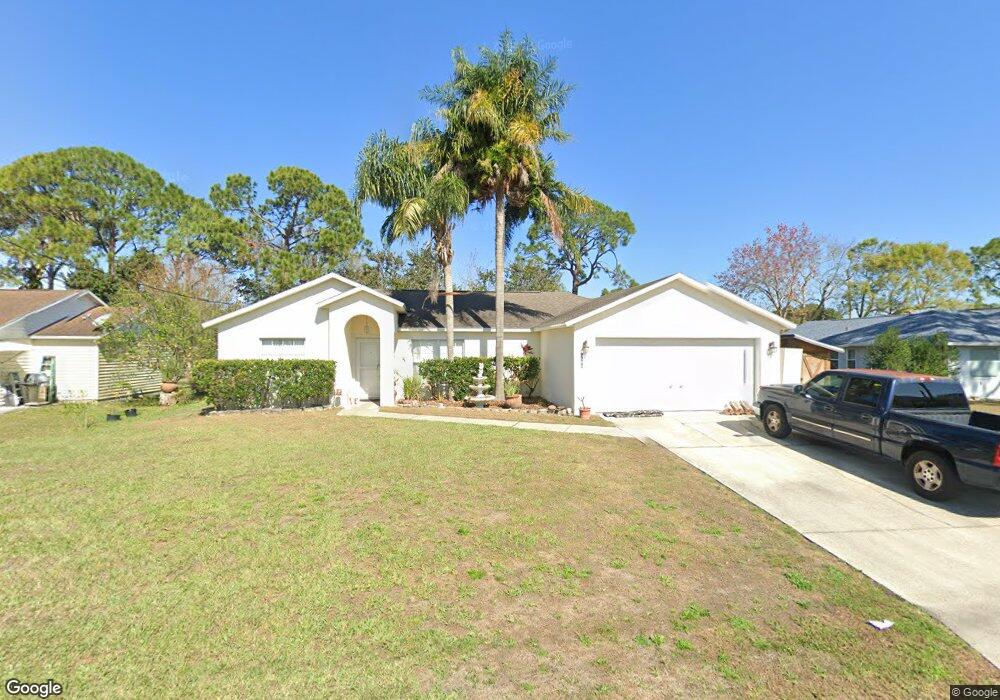
About This Home
This home is located at 5186 Bridge Rd, Cocoa, FL 32927 and is currently estimated at $319,127, approximately $235 per square foot. 5186 Bridge Rd is a home located in Brevard County with nearby schools including Challenger 7 Elementary School, Space Coast Junior/Senior High School, and East Atlantic Prep of Brevard County.
Ownership History
Date
Name
Owned For
Owner Type
Purchase Details
Closed on
May 29, 2013
Sold by
Veit Lewis A and Veit Maria M
Bought by
Veit Lewis A and Veit Maria M
Current Estimated Value
Purchase Details
Closed on
Feb 23, 2006
Sold by
Veit Jane Alyce
Bought by
Veit Jane Alyce and Veit Lewis A
Home Financials for this Owner
Home Financials are based on the most recent Mortgage that was taken out on this home.
Original Mortgage
$63,000
Interest Rate
6.19%
Purchase Details
Closed on
Jun 29, 1998
Sold by
Whited William
Bought by
Veit Jane Alyce
Create a Home Valuation Report for This Property
The Home Valuation Report is an in-depth analysis detailing your home's value as well as a comparison with similar homes in the area
Home Values in the Area
Average Home Value in this Area
Purchase History
| Date | Buyer | Sale Price | Title Company |
|---|---|---|---|
| Veit Lewis A | -- | Attorney | |
| Veit Jane Alyce | -- | K E L Title Ins Agency Inc | |
| Veit Jane Alyce | $8,500 | -- |
Source: Public Records
Mortgage History
| Date | Status | Borrower | Loan Amount |
|---|---|---|---|
| Previous Owner | Veit Jane Alyce | $63,000 |
Source: Public Records
Tax History
| Year | Tax Paid | Tax Assessment Tax Assessment Total Assessment is a certain percentage of the fair market value that is determined by local assessors to be the total taxable value of land and additions on the property. | Land | Improvement |
|---|---|---|---|---|
| 2025 | $1,333 | $101,330 | -- | -- |
| 2024 | $1,298 | $98,480 | -- | -- |
| 2023 | $1,298 | $95,620 | $0 | $0 |
| 2022 | $1,207 | $92,840 | $0 | $0 |
| 2021 | $1,204 | $90,140 | $0 | $0 |
| 2020 | $1,153 | $88,900 | $0 | $0 |
| 2019 | $1,089 | $86,910 | $0 | $0 |
| 2018 | $1,081 | $85,290 | $0 | $0 |
| 2017 | $1,074 | $83,540 | $0 | $0 |
| 2016 | $1,073 | $81,830 | $18,000 | $63,830 |
| 2015 | $1,083 | $81,270 | $15,000 | $66,270 |
| 2014 | $1,083 | $80,630 | $11,000 | $69,630 |
Source: Public Records
Map
Nearby Homes
- 5950 Ackard Ave
- 5945 Coker Ave
- 6020 Cannon Ave
- 5946 Deer Ln
- 5221 Carrick Rd
- 6094 Cardiff Ave
- 5215 Holden Rd
- 5914 Stillwater Ave
- 5220 Holden Rd
- 4905 Bridge Rd
- 4975 Fay Blvd
- 6210 Stillwater Ave
- 6375 Cable Ave
- 5265 Fay Blvd
- 6438 Hudson Rd
- 5720 Flint Rd
- 6450 Ember Ave
- 000 Port Saint John Pkwy
- 6310 Depot Ave
- 00 Unknown
- 5198 Bridge Rd
- 5910 Cannon Ave
- Tbd Bridge Rd
- 5211 Sanbourne St
- 5201 Sanbourne St
- 5210 Bridge Rd
- 5193 Bridge Rd
- 5181 Bridge Rd Unit 4
- 5205 Bridge Rd
- 5231 Sanbourne St
- 5169 Bridge Rd
- 5915 Cannon Ave
- 5222 Bridge Rd
- 5217 Bridge Rd
- 5925 Cannon Ave
- 5157 Bridge Rd
- 5241 Sanbourne St
- 5210 Sanbourne St
- 5146 Bridge Rd
- 5935 Cannon Ave Unit 2418
Your Personal Tour Guide
Ask me questions while you tour the home.