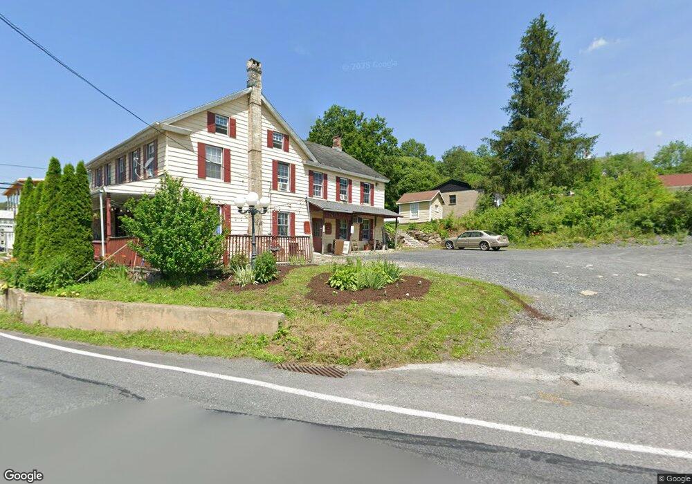
5189 Rr 5 Kunkletown, PA 18058
Estimated Value: $284,770 - $364,000
3
Beds
1
Bath
1,232
Sq Ft
$268/Sq Ft
Est. Value
About This Home
This home is located at 5189 Rr 5, Kunkletown, PA 18058 and is currently estimated at $329,693, approximately $267 per square foot. 5189 Rr 5 is a home located in Monroe County with nearby schools including Pleasant Valley Elementary School, Pleasant Valley Intermediate School, and Pleasant Valley Middle School.
Ownership History
Date
Name
Owned For
Owner Type
Purchase Details
Closed on
Feb 2, 2018
Sold by
Hough Willis H and Hough Kyle
Bought by
Kuehner Kenneth and Kuehner Kenneth
Current Estimated Value
Home Financials for this Owner
Home Financials are based on the most recent Mortgage that was taken out on this home.
Original Mortgage
$136,000
Outstanding Balance
$115,035
Interest Rate
3.94%
Mortgage Type
New Conventional
Estimated Equity
$214,658
Purchase Details
Closed on
Dec 18, 2017
Sold by
Morrissey Esquire Philip Patrick
Bought by
Hough Willis H and Hough Kyle
Home Financials for this Owner
Home Financials are based on the most recent Mortgage that was taken out on this home.
Original Mortgage
$136,000
Outstanding Balance
$115,035
Interest Rate
3.94%
Mortgage Type
New Conventional
Estimated Equity
$214,658
Purchase Details
Closed on
May 16, 1978
Bought by
Burger Stanley
Create a Home Valuation Report for This Property
The Home Valuation Report is an in-depth analysis detailing your home's value as well as a comparison with similar homes in the area
Home Values in the Area
Average Home Value in this Area
Purchase History
| Date | Buyer | Sale Price | Title Company |
|---|---|---|---|
| Kuehner Kenneth | $160,000 | Gateway Abstract | |
| Hough Willis H | -- | None Available | |
| Burger Stanley | -- | -- |
Source: Public Records
Mortgage History
| Date | Status | Borrower | Loan Amount |
|---|---|---|---|
| Open | Kuehner Kenneth | $136,000 |
Source: Public Records
Tax History Compared to Growth
Tax History
| Year | Tax Paid | Tax Assessment Tax Assessment Total Assessment is a certain percentage of the fair market value that is determined by local assessors to be the total taxable value of land and additions on the property. | Land | Improvement |
|---|---|---|---|---|
| 2025 | $1,023 | $158,240 | $40,940 | $117,300 |
| 2024 | $728 | $158,240 | $40,940 | $117,300 |
| 2023 | $4,507 | $158,240 | $40,940 | $117,300 |
| 2022 | $4,377 | $158,240 | $40,940 | $117,300 |
| 2021 | $4,277 | $158,240 | $40,940 | $117,300 |
| 2020 | $4,377 | $158,240 | $40,940 | $117,300 |
| 2019 | $2,994 | $17,080 | $2,540 | $14,540 |
| 2018 | $2,960 | $17,080 | $2,540 | $14,540 |
| 2017 | $2,960 | $17,080 | $2,540 | $14,540 |
| 2016 | $436 | $17,080 | $2,540 | $14,540 |
| 2015 | -- | $17,080 | $2,540 | $14,540 |
| 2014 | -- | $16,930 | $2,390 | $14,540 |
Source: Public Records
Map
Nearby Homes
- 0 Pleasant View Dr
- 3036 Pleasant View Dr Unit 28
- Lot E 25 Pleasant View Dr
- 3315 Aspen Rd Unit PVL
- 0 Ashley Ct I
- 0 Ashley Ct H15
- 160 Grassy Rd
- 6316 Overlook Dr
- 6311 Overlook Dr
- Lot 34 Overlook Dr
- 122 Leisure Ln
- 376 H T Y Rd
- 376 Hty Rd
- Lr 45003 Gilbert Rd
- Lot 13 Pine Tree Ln
- 0 Laurel Ln 403 Ln
- 131 Chinaberry Way
- 124 Red Bud Ln
- 116 Red Bud Ln
- 0 Sr 209 Unit PM-130225