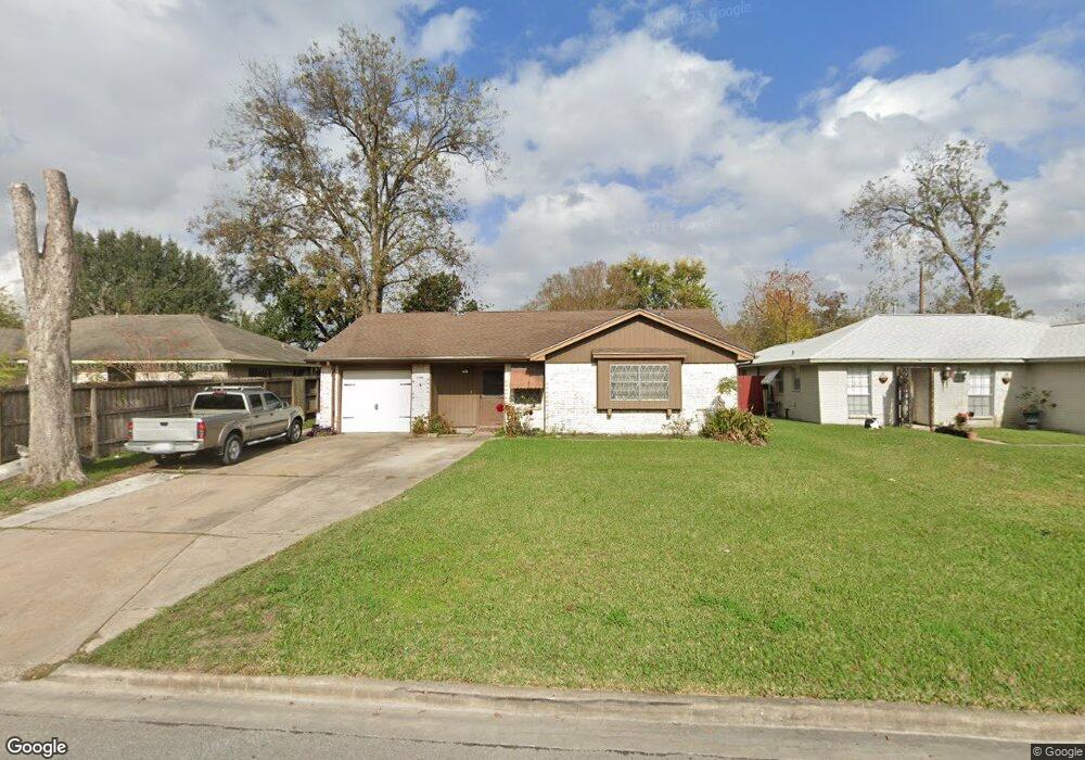
519 Branding Iron Ln Houston, TX 77060
Aldine NeighborhoodEstimated Value: $187,543 - $201,000
3
Beds
2
Baths
1,089
Sq Ft
$178/Sq Ft
Est. Value
About This Home
This home is located at 519 Branding Iron Ln, Houston, TX 77060 and is currently estimated at $193,886, approximately $178 per square foot. 519 Branding Iron Ln is a home located in Harris County with nearby schools including Hinojosa EC/PK/K, Odom Elementary School, and Aldine Ninth Grade School.
Ownership History
Date
Name
Owned For
Owner Type
Purchase Details
Closed on
Oct 20, 1995
Sold by
Colter Marissa Lynn and Hill Robert Thurston
Bought by
Alfaro Saul and Lopez Maria Dolores
Current Estimated Value
Home Financials for this Owner
Home Financials are based on the most recent Mortgage that was taken out on this home.
Original Mortgage
$45,436
Outstanding Balance
$319
Interest Rate
7.62%
Mortgage Type
FHA
Estimated Equity
$193,567
Create a Home Valuation Report for This Property
The Home Valuation Report is an in-depth analysis detailing your home's value as well as a comparison with similar homes in the area
Home Values in the Area
Average Home Value in this Area
Purchase History
| Date | Buyer | Sale Price | Title Company |
|---|---|---|---|
| Alfaro Saul | -- | -- |
Source: Public Records
Mortgage History
| Date | Status | Borrower | Loan Amount |
|---|---|---|---|
| Open | Alfaro Saul | $45,436 |
Source: Public Records
Tax History Compared to Growth
Tax History
| Year | Tax Paid | Tax Assessment Tax Assessment Total Assessment is a certain percentage of the fair market value that is determined by local assessors to be the total taxable value of land and additions on the property. | Land | Improvement |
|---|---|---|---|---|
| 2025 | $160 | $177,051 | $32,652 | $144,399 |
| 2024 | $160 | $177,051 | $32,652 | $144,399 |
| 2023 | $160 | $177,051 | $32,652 | $144,399 |
| 2022 | $2,106 | $147,295 | $17,186 | $130,109 |
| 2021 | $2,014 | $110,237 | $17,186 | $93,051 |
| 2020 | $1,932 | $102,045 | $17,186 | $84,859 |
| 2019 | $1,839 | $86,748 | $15,467 | $71,281 |
| 2018 | $650 | $70,277 | $15,467 | $54,810 |
| 2017 | $1,593 | $70,277 | $15,467 | $54,810 |
| 2016 | $1,593 | $70,277 | $15,467 | $54,810 |
| 2015 | $1,144 | $70,277 | $15,467 | $54,810 |
| 2014 | $1,144 | $63,830 | $15,467 | $48,363 |
Source: Public Records
Map
Nearby Homes
- 530 Branding Iron Ln
- 522 Hollyvale Dr
- 611 Glenvale Dr
- 631 Branding Iron Ln
- 710 Ridgeland Ct
- TBD W Hastings St
- 615 Corvette Ln
- 527 Walston Ln
- 547 Walston Ln
- 726 Corvette Ct
- 255 Mcfarland Rd
- 502 Walston Ln
- 15035 Lillja Rd
- 14814 Mcleod Dr
- 15114 Kaler Rd
- 14929 Henry Rd
- 15123 Kaler Rd
- 543 Dalewood Dr
- 132 Hambrick Rd
- 814 Isetta Ln
- 523 Branding Iron Ln
- 515 Branding Iron Ln
- 518 Glenvale Dr
- 527 Branding Iron Ln
- 511 Branding Iron Ln
- 522 Glenvale Dr
- 514 Glenvale Dr
- 526 Glenvale Dr
- 510 Glenvale Dr
- 518 Branding Iron Ln
- 514 Branding Iron Ln
- 531 Branding Iron Ln
- 507 Branding Iron Ln
- 522 Branding Iron Ln
- 510 Branding Iron Ln
- 526 Branding Iron Ln
- 530 Glenvale Dr
- 506 Glenvale Dr
- 535 Branding Iron Ln
- 506 Branding Iron Ln