
Seller's Agent in 2015
Vickie Giles-Griffin
Re/Max Of Albany
120 Total Sales
Estimated Value: $150,000 - $216,000
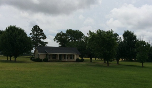
Country Living at its BEST. Corner Lot with a Pond. Huge master bedroom with a large master bath that has a roll in shower. The laundry is in separate closet in the master...what convenience. The second bedroom has carpet and is located just off the master. Large Family room is just off of the kitchen. Plantation blinds....laminate flooring in family room kitchen and master...Ceramic tile in the master bath. The kitchen has lots of cabinets and a large pantry. The seller will allow $ 1000.00 for a new dishwasher venthood and stove...your choice. 5.23 acres of land with a pond. Call today on this one and get packing to move to Doerun.
Last Agent to Sell the Property
Re/Max Of Albany Brokerage Phone: 2294341600 License #47729 Listed on: 06/03/2015
Last Buyer's Agent
Re/Max Of Albany Brokerage Phone: 2294341600 License #47729 Listed on: 06/03/2015
| Date | Buyer | Sale Price | Title Company |
|---|---|---|---|
| Etheredge Talmadge | $95,000 | -- | |
| Howell Deborah B | -- | -- | |
| Howell Roger Earl | -- | -- |
| Date | Status | Borrower | Loan Amount |
|---|---|---|---|
| Open | Etheredge Talmadge | $75,000 |
| Date | Event | Price | List to Sale | Price per Sq Ft |
|---|---|---|---|---|
| 06/30/2015 06/30/15 | Sold | $95,000 | -- | $72 / Sq Ft |
| 06/03/2015 06/03/15 | Pending | -- | -- | -- |
| Year | Tax Paid | Tax Assessment Tax Assessment Total Assessment is a certain percentage of the fair market value that is determined by local assessors to be the total taxable value of land and additions on the property. | Land | Improvement |
|---|---|---|---|---|
| 2024 | $1,457 | $43,715 | $10,748 | $32,967 |
| 2023 | $1,457 | $44,275 | $10,748 | $33,527 |
| 2022 | $1,474 | $44,275 | $10,748 | $33,527 |
| 2021 | $1,450 | $44,275 | $10,748 | $33,527 |
| 2020 | $1,452 | $44,275 | $10,748 | $33,527 |
| 2019 | $1,452 | $44,275 | $10,748 | $33,527 |
| 2018 | $1,269 | $44,275 | $10,748 | $33,527 |
| 2017 | $1,134 | $39,574 | $10,748 | $28,826 |
| 2016 | $1,033 | $39,574 | $10,748 | $28,826 |
| 2015 | $1,136 | $39,574 | $10,748 | $28,826 |
| 2014 | $1,136 | $39,574 | $10,748 | $28,826 |
| 2013 | -- | $40,182 | $11,357 | $28,826 |
| 2012 | -- | $40,182 | $11,356 | $28,825 |
Seller's Agent in 2015
Vickie Giles-Griffin
Re/Max Of Albany
120 Total Sales
Source: Albany Board of REALTORS®
MLS Number: 133932
APN: 00500-013-00A