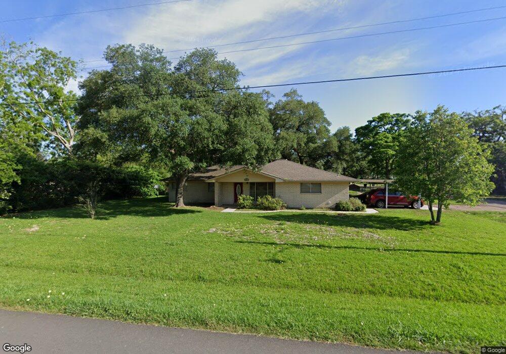
519 Mulberry Ln Brazoria, TX 77422
Estimated Value: $215,000 - $267,000
--
Bed
2
Baths
1,488
Sq Ft
$162/Sq Ft
Est. Value
About This Home
This home is located at 519 Mulberry Ln, Brazoria, TX 77422 and is currently estimated at $241,729, approximately $162 per square foot. 519 Mulberry Ln is a home located in Brazoria County.
Ownership History
Date
Name
Owned For
Owner Type
Purchase Details
Closed on
Sep 19, 2005
Sold by
Lebouef Mark E
Bought by
Lebouef Melanie L
Current Estimated Value
Home Financials for this Owner
Home Financials are based on the most recent Mortgage that was taken out on this home.
Original Mortgage
$79,600
Outstanding Balance
$42,345
Interest Rate
5.76%
Mortgage Type
Stand Alone First
Estimated Equity
$199,384
Purchase Details
Closed on
Sep 30, 2004
Sold by
Lebouef Melanie
Bought by
Lebouef Melanie L and Lebouef Mark E
Create a Home Valuation Report for This Property
The Home Valuation Report is an in-depth analysis detailing your home's value as well as a comparison with similar homes in the area
Home Values in the Area
Average Home Value in this Area
Purchase History
| Date | Buyer | Sale Price | Title Company |
|---|---|---|---|
| Lebouef Melanie L | -- | Stewart Title Brazoria | |
| Lebouef Melanie L | -- | -- |
Source: Public Records
Mortgage History
| Date | Status | Borrower | Loan Amount |
|---|---|---|---|
| Open | Lebouef Melanie L | $79,600 |
Source: Public Records
Tax History Compared to Growth
Tax History
| Year | Tax Paid | Tax Assessment Tax Assessment Total Assessment is a certain percentage of the fair market value that is determined by local assessors to be the total taxable value of land and additions on the property. | Land | Improvement |
|---|---|---|---|---|
| 2025 | $1,248 | $193,600 | $28,220 | $218,280 |
| 2023 | $1,248 | $164,161 | $25,700 | $211,430 |
| 2022 | $3,371 | $149,237 | $22,680 | $138,300 |
| 2021 | $3,198 | $135,670 | $19,660 | $116,010 |
| 2020 | $3,252 | $131,450 | $18,140 | $113,310 |
| 2019 | $3,120 | $126,430 | $15,960 | $110,470 |
| 2018 | $2,852 | $111,120 | $21,070 | $90,050 |
| 2017 | $2,892 | $108,950 | $15,960 | $92,990 |
| 2016 | $2,892 | $108,950 | $15,960 | $92,990 |
| 2015 | $2,106 | $111,000 | $15,960 | $95,040 |
| 2014 | $2,106 | $94,180 | $15,960 | $78,220 |
Source: Public Records
Map
Nearby Homes
- 523 Lazy Ln
- 307 Avenue G
- 229 Yaupon Dr
- 0 Pecan Dr
- 232 Magnolia St
- 409 Carlton St
- 1208 S Brooks St
- 706 E New York St
- 34654 Fm 521 Rd
- 8922 Fm 521 Rd
- 230 E New York St
- 549 E New York St
- 4773 County Road 652
- 310 E Texas St
- 206 S Market St
- 401 E Texas St
- 0 Cr-747a
- TBD Cr-318
- 320 Cr-320
- 0 Cr-318 Unit 18304666