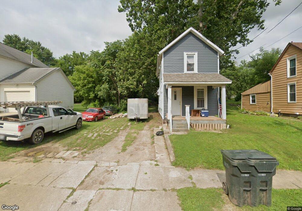
519 N Mulberry St Mansfield, OH 44902
Estimated Value: $69,732 - $86,000
2
Beds
1
Bath
984
Sq Ft
$75/Sq Ft
Est. Value
About This Home
This home is located at 519 N Mulberry St, Mansfield, OH 44902 and is currently estimated at $73,933, approximately $75 per square foot. 519 N Mulberry St is a home located in Richland County with nearby schools including Goal Digital Academy, St. Peter's Elementary/Montessori School, and St. Peter's High School/Junior High.
Ownership History
Date
Name
Owned For
Owner Type
Purchase Details
Closed on
Jul 12, 2018
Sold by
Richland County Land Reutilization Corp
Bought by
Iraheta Amanda D
Current Estimated Value
Purchase Details
Closed on
Jun 18, 2018
Sold by
Na
Bought by
Richard County Land Reutilizaiton Corpor
Purchase Details
Closed on
Apr 28, 1994
Sold by
Longood William M
Bought by
Longood Michael W
Purchase Details
Closed on
Jun 4, 1992
Sold by
Todd Joshua D
Bought by
Longood William M
Create a Home Valuation Report for This Property
The Home Valuation Report is an in-depth analysis detailing your home's value as well as a comparison with similar homes in the area
Home Values in the Area
Average Home Value in this Area
Purchase History
| Date | Buyer | Sale Price | Title Company |
|---|---|---|---|
| Iraheta Amanda D | -- | Chicago Title | |
| Richard County Land Reutilizaiton Corpor | -- | None Available | |
| Longood Michael W | -- | -- | |
| Longood William M | $6,000 | -- |
Source: Public Records
Tax History Compared to Growth
Tax History
| Year | Tax Paid | Tax Assessment Tax Assessment Total Assessment is a certain percentage of the fair market value that is determined by local assessors to be the total taxable value of land and additions on the property. | Land | Improvement |
|---|---|---|---|---|
| 2024 | $669 | $13,610 | $1,870 | $11,740 |
| 2023 | $637 | $13,610 | $1,870 | $11,740 |
| 2022 | $581 | $10,390 | $1,700 | $8,690 |
| 2021 | $585 | $10,390 | $1,700 | $8,690 |
| 2020 | $598 | $10,390 | $1,700 | $8,690 |
| 2019 | $608 | $9,530 | $840 | $8,690 |
| 2018 | $599 | $9,530 | $840 | $8,690 |
| 2017 | $508 | $9,530 | $840 | $8,690 |
| 2016 | $432 | $6,850 | $1,330 | $5,520 |
| 2015 | $432 | $6,850 | $1,330 | $5,520 |
| 2014 | $408 | $6,850 | $1,330 | $5,520 |
| 2012 | $311 | $6,850 | $1,400 | $5,450 |
Source: Public Records
Map
Nearby Homes
- 156 Buckingham Ave Unit 158
- 452 Daisy St
- 526 Bowman St
- 283 Bulkley Ave
- 371 Bell St
- 0 Voegele Ave Unit Lot 6048, 6049, 6
- 743 Bowman St
- 426 Mcpherson St
- 362-364 W 6th St
- 169 W 5th St
- 219 W 5th St
- 282 W 5th St
- 346 Newman St
- 458 Wayne St
- 512 Burns St
- 0 Highway 30
- 311 Auburn St
- 82 N Adams St
- 406 Sherman Place
- 237 Helen Ave
- 523 N Mulberry St
- 511 N Mulberry St
- 525 N Mulberry St
- 549 N Mulberry St
- 533 N Mulberry St
- 500 Lida St
- 537 N Mulberry St
- 504 Lida St
- 518 N Mulberry St
- 516 Lida St
- 146 Harker St
- 524 N Mulberry St
- 510 N Mulberry St
- 130 Harker St
- 506 N Mulberry St
- 504 N Mulberry St
- 543 N Mulberry St
- 154 Harker St
- 520 Lida St
- 140 Harker St