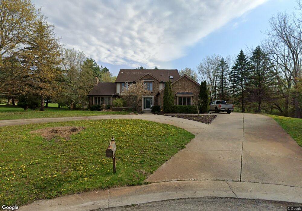
5190 Alta Ct Unit Bldg-Unit Clarkston, MI 48348
Estimated Value: $586,000 - $671,000
5
Beds
3
Baths
3,267
Sq Ft
$189/Sq Ft
Est. Value
About This Home
This home is located at 5190 Alta Ct Unit Bldg-Unit, Clarkston, MI 48348 and is currently estimated at $616,359, approximately $188 per square foot. 5190 Alta Ct Unit Bldg-Unit is a home located in Oakland County with nearby schools including Everest Academy.
Ownership History
Date
Name
Owned For
Owner Type
Purchase Details
Closed on
Nov 7, 2023
Sold by
Page Rilee and Page Kelvin Michael
Bought by
Veress Arthur and Veress Lisa Arredondo
Current Estimated Value
Purchase Details
Closed on
Jan 16, 2018
Sold by
Raisch Julie Gibson and Griffin Peter G
Bought by
Page Kelvin Michael and Page Rilee
Purchase Details
Closed on
Jan 2, 2015
Sold by
Griffin Peter G
Bought by
Raisch Griffin Julie and Griffin Peter G
Home Financials for this Owner
Home Financials are based on the most recent Mortgage that was taken out on this home.
Original Mortgage
$252,000
Interest Rate
4.19%
Mortgage Type
New Conventional
Purchase Details
Closed on
Nov 7, 2014
Sold by
Townsend Lawrence F and Leigh Nicole L
Bought by
Griffin Peter G
Home Financials for this Owner
Home Financials are based on the most recent Mortgage that was taken out on this home.
Original Mortgage
$252,000
Interest Rate
4.19%
Mortgage Type
New Conventional
Purchase Details
Closed on
Aug 13, 2003
Sold by
Townsend Lawrence F
Bought by
Townsend Lawrence F and Leigh Nicole L
Home Financials for this Owner
Home Financials are based on the most recent Mortgage that was taken out on this home.
Original Mortgage
$277,000
Interest Rate
6.33%
Mortgage Type
Purchase Money Mortgage
Purchase Details
Closed on
May 31, 2002
Sold by
Dennis R Hoadley Tr
Bought by
Townsend L
Home Financials for this Owner
Home Financials are based on the most recent Mortgage that was taken out on this home.
Original Mortgage
$280,000
Interest Rate
6.82%
Mortgage Type
Purchase Money Mortgage
Purchase Details
Closed on
Mar 9, 1995
Sold by
Mead Jeffrey R
Bought by
Hoadley Dennis R
Home Financials for this Owner
Home Financials are based on the most recent Mortgage that was taken out on this home.
Original Mortgage
$106,550
Interest Rate
8.97%
Mortgage Type
New Conventional
Create a Home Valuation Report for This Property
The Home Valuation Report is an in-depth analysis detailing your home's value as well as a comparison with similar homes in the area
Home Values in the Area
Average Home Value in this Area
Purchase History
| Date | Buyer | Sale Price | Title Company |
|---|---|---|---|
| Veress Arthur | $562,500 | None Listed On Document | |
| Veress Arthur | $562,500 | None Listed On Document | |
| Page Kelvin Michael | $374,900 | None Available | |
| Raisch Griffin Julie | -- | None Available | |
| Griffin Peter G | $315,000 | First American Title | |
| Townsend Lawrence F | -- | Lawyers Title Insurance Corp | |
| Townsend L | $350,000 | -- | |
| Hoadley Dennis R | $247,500 | -- |
Source: Public Records
Mortgage History
| Date | Status | Borrower | Loan Amount |
|---|---|---|---|
| Previous Owner | Griffin Peter G | $252,000 | |
| Previous Owner | Townsend Lawrence F | $277,000 | |
| Previous Owner | Townsend L | $280,000 | |
| Previous Owner | Hoadley Dennis R | $106,550 |
Source: Public Records
Tax History
| Year | Tax Paid | Tax Assessment Tax Assessment Total Assessment is a certain percentage of the fair market value that is determined by local assessors to be the total taxable value of land and additions on the property. | Land | Improvement |
|---|---|---|---|---|
| 2025 | -- | $292,100 | $46,400 | $245,700 |
| 2024 | $6,204 | $274,000 | $41,500 | $232,500 |
| 2023 | $5,890 | $204,400 | $39,100 | $165,300 |
| 2022 | $5,890 | $184,100 | $36,300 | $147,800 |
| 2021 | $5,891 | $178,100 | $38,000 | $140,100 |
| 2020 | $3,813 | $175,200 | $38,100 | $137,100 |
| 2018 | $5,565 | $166,200 | $33,600 | $132,600 |
| 2015 | -- | $170,500 | $0 | $0 |
| 2014 | -- | $151,900 | $0 | $0 |
| 2011 | -- | $133,300 | $0 | $0 |
Source: Public Records
Map
Nearby Homes
- 6886 Vail Ct
- 00 Waldon Rd
- 5479 Woodcreek Ct Unit 13
- 7286 Pine Knob Rd
- 7428 Foxburg Ct
- 7247 Ardsley Ln
- 0 Pine Knob Rd Unit 20261012338
- 0 Pine Knob Rd Unit 26007075
- 5095 Maybee Rd
- 7640 Clintonville Rd
- 6997 Oakhurst Ridge Rd
- 00 Clarkston Rd
- 7811 Caberfae Trail
- 7165 Sashabaw Rd
- 5530 Fox Chase Ln
- 3006 Sheffield Cir
- 3013 Sheffield Cir
- 3019 Sheffield Cir
- 3021 Sheffield Cir
- 3024 Sheffield Cir
- 5190 Alta Ct
- 5210 Alta Ct
- 5170 Alta Ct
- 6574 Sun Valley Dr
- 5191 Alta Ct
- 5175 Tahoe Ct
- 6514 Sun Valley Dr
- 6563 Sun Valley Dr
- 6600 Sun Valley Dr
- 5155 Tahoe Ct
- 6587 Sun Valley Dr
- 6539 Sun Valley Dr
- 5195 Tahoe Ct
- 6515 Sun Valley Dr
- 5174 Tahoe Ct
- 6611 Sun Valley Dr
- 6640 Pine Knob Rd
- 5165 Waldon Rd
- 5197 Waldon Rd
- 5217 Sun Valley Ct
Your Personal Tour Guide
Ask me questions while you tour the home.