Estimated Value: $283,371 - $336,000
3
Beds
2
Baths
1,216
Sq Ft
$255/Sq Ft
Est. Value
About This Home
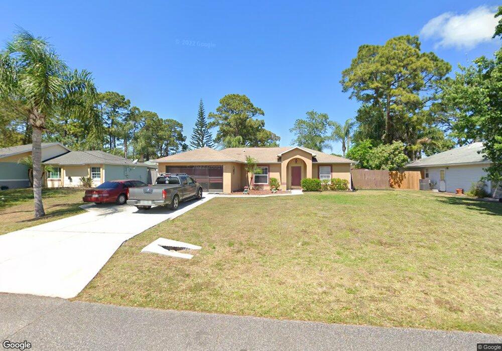
This home is located at 5190 Holden Rd, Cocoa, FL 32927 and is currently estimated at $310,343, approximately $255 per square foot. 5190 Holden Rd is a home located in Brevard County with nearby schools including Challenger 7 Elementary School, Space Coast Junior/Senior High School, and Sculptor Charter School.
Ownership History
Date
Name
Owned For
Owner Type
Purchase Details
Closed on
Jan 27, 2003
Sold by
Forbes Sherri L and Augustine Noel A
Bought by
Forbes Sherri L
Current Estimated Value
Purchase Details
Closed on
Mar 18, 2002
Sold by
Holiday Bldr Inc
Bought by
Forbes Sherri L and Augustin Noel A
Home Financials for this Owner
Home Financials are based on the most recent Mortgage that was taken out on this home.
Original Mortgage
$90,839
Interest Rate
6.85%
Mortgage Type
Purchase Money Mortgage
Purchase Details
Closed on
Aug 15, 2001
Sold by
Schoeler George A and Schoeler Woodine H
Bought by
Holiday Builders Inc
Create a Home Valuation Report for This Property
The Home Valuation Report is an in-depth analysis detailing your home's value as well as a comparison with similar homes in the area
Home Values in the Area
Average Home Value in this Area
Purchase History
| Date | Buyer | Sale Price | Title Company |
|---|---|---|---|
| Forbes Sherri L | $44,500 | -- | |
| Forbes Sherri L | $92,300 | -- | |
| Holiday Builders Inc | $13,500 | -- |
Source: Public Records
Mortgage History
| Date | Status | Borrower | Loan Amount |
|---|---|---|---|
| Previous Owner | Forbes Sherri L | $90,839 |
Source: Public Records
Tax History
| Year | Tax Paid | Tax Assessment Tax Assessment Total Assessment is a certain percentage of the fair market value that is determined by local assessors to be the total taxable value of land and additions on the property. | Land | Improvement |
|---|---|---|---|---|
| 2025 | $1,061 | $84,130 | -- | -- |
| 2024 | $1,025 | $81,760 | -- | -- |
| 2023 | $1,025 | $79,380 | $0 | $0 |
| 2022 | $1,004 | $77,070 | $0 | $0 |
| 2021 | $993 | $74,830 | $0 | $0 |
| 2020 | $947 | $73,800 | $0 | $0 |
| 2019 | $895 | $72,150 | $0 | $0 |
| 2018 | $896 | $70,810 | $0 | $0 |
| 2017 | $898 | $69,360 | $0 | $0 |
| 2016 | $906 | $67,940 | $18,000 | $49,940 |
| 2015 | $914 | $67,470 | $15,000 | $52,470 |
| 2014 | $919 | $66,940 | $11,000 | $55,940 |
Source: Public Records
Map
Nearby Homes
- 5220 Holden Rd
- 5215 Holden Rd
- 5221 Carrick Rd
- 6094 Cardiff Ave
- 6020 Cannon Ave
- 6375 Cable Ave
- 4975 Fay Blvd
- 6450 Ember Ave
- 00 Unknown
- 6210 Stillwater Ave
- 5265 Fay Blvd
- 5945 Coker Ave
- 6438 Hudson Rd
- 0000 Grissom Pkwy
- 5946 Deer Ln
- 6310 Depot Ave
- 5914 Stillwater Ave
- 6481 La Brea Ave
- 6620 Grissom Pkwy
- 5095 Hogan Place
Your Personal Tour Guide
Ask me questions while you tour the home.