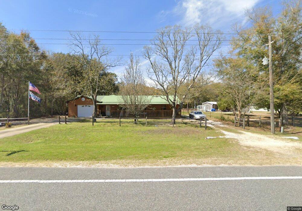
5197 County Highway 1087 Defuniak Springs, FL 32433
Estimated Value: $238,000 - $329,000
3
Beds
1
Bath
1,975
Sq Ft
$144/Sq Ft
Est. Value
About This Home
This home is located at 5197 County Highway 1087, Defuniak Springs, FL 32433 and is currently estimated at $283,581, approximately $143 per square foot. 5197 County Highway 1087 is a home located in Walton County with nearby schools including Paxton School.
Ownership History
Date
Name
Owned For
Owner Type
Purchase Details
Closed on
Apr 30, 2024
Sold by
Sadler Wanda G and Simmons Wanda G
Bought by
Simmons Wanda G and Simmons Horace J
Current Estimated Value
Purchase Details
Closed on
Nov 7, 2013
Sold by
Suggs Larry Joe
Bought by
Sadler Wanda G
Purchase Details
Closed on
Oct 12, 2005
Sold by
Suggs Wanda S
Bought by
Suggs Larry J and Suggs Wanda S
Home Financials for this Owner
Home Financials are based on the most recent Mortgage that was taken out on this home.
Original Mortgage
$108,000
Interest Rate
5.66%
Mortgage Type
New Conventional
Purchase Details
Closed on
Feb 25, 2004
Sold by
Bigger Robert L
Bought by
Suggs Wanda S
Create a Home Valuation Report for This Property
The Home Valuation Report is an in-depth analysis detailing your home's value as well as a comparison with similar homes in the area
Home Values in the Area
Average Home Value in this Area
Purchase History
| Date | Buyer | Sale Price | Title Company |
|---|---|---|---|
| Simmons Wanda G | $100 | None Listed On Document | |
| Simmons Wanda G | $100 | None Listed On Document | |
| Sadler Wanda G | -- | None Available | |
| Suggs Larry J | -- | Associated Land Title Group | |
| Suggs Wanda S | -- | -- |
Source: Public Records
Mortgage History
| Date | Status | Borrower | Loan Amount |
|---|---|---|---|
| Previous Owner | Suggs Larry J | $108,000 |
Source: Public Records
Tax History Compared to Growth
Tax History
| Year | Tax Paid | Tax Assessment Tax Assessment Total Assessment is a certain percentage of the fair market value that is determined by local assessors to be the total taxable value of land and additions on the property. | Land | Improvement |
|---|---|---|---|---|
| 2024 | $674 | $112,536 | -- | -- |
| 2023 | $674 | $109,258 | $0 | $0 |
| 2022 | $663 | $106,076 | $0 | $0 |
| 2021 | $629 | $98,610 | $0 | $0 |
| 2020 | $638 | $97,249 | $6,000 | $91,249 |
| 2019 | $617 | $95,388 | $0 | $0 |
| 2018 | $604 | $93,609 | $0 | $0 |
| 2017 | $0 | $93,245 | $0 | $0 |
| 2016 | $591 | $91,327 | $0 | $0 |
| 2015 | -- | $90,692 | $0 | $0 |
| 2014 | -- | $91,726 | $0 | $0 |
Source: Public Records
Map
Nearby Homes
- 5783 Co Rd 1087
- 5783 County Highway 1087
- Lot 1 County Highway 1087
- Lot 2 County Highway 1087
- 0 Long Rd Unit 985416
- 768 Long Rd
- Lot 37 Plantation Ln
- 682 Williams Rd
- 1.3 Williams Rd
- 0.46 Williams Rd
- 2848 Williams Rd
- 1.25 Acres Granger Rd
- 81 Lee Ann Ln
- 240 Lee Ann Ln
- 290 Lee Ann Ln
- 000 Long Rd
- 1.25 acres N Sally Jean Rd
- 547 New Harmony Loop
- 0 Jean Rd Unit MFRGC512409
- X Eagles Way
- 5186 County Highway 1087
- 5175 County Highway 1087
- 5111 County Highway 1087
- 5373 County Highway 1087
- 5483 County Highway 1087
- 5519 County Highway 1087
- 5581 County Highway 1087
- 5581 Hwy 1087
- 5625 County Highway 1087
- 229 Harbuck Rd
- 5731 Co Highway 1087
- 4646 County Highway 1087
- 6.27 ACRES Hwy 1087
- 179 Danny Dr
- 160 Danny Dr
- 83 Danny Dr
- 6190 Williams Rd
- 1.44 AC Cr-1087
- XXX Danny Dr
- 530 Harbuck Rd