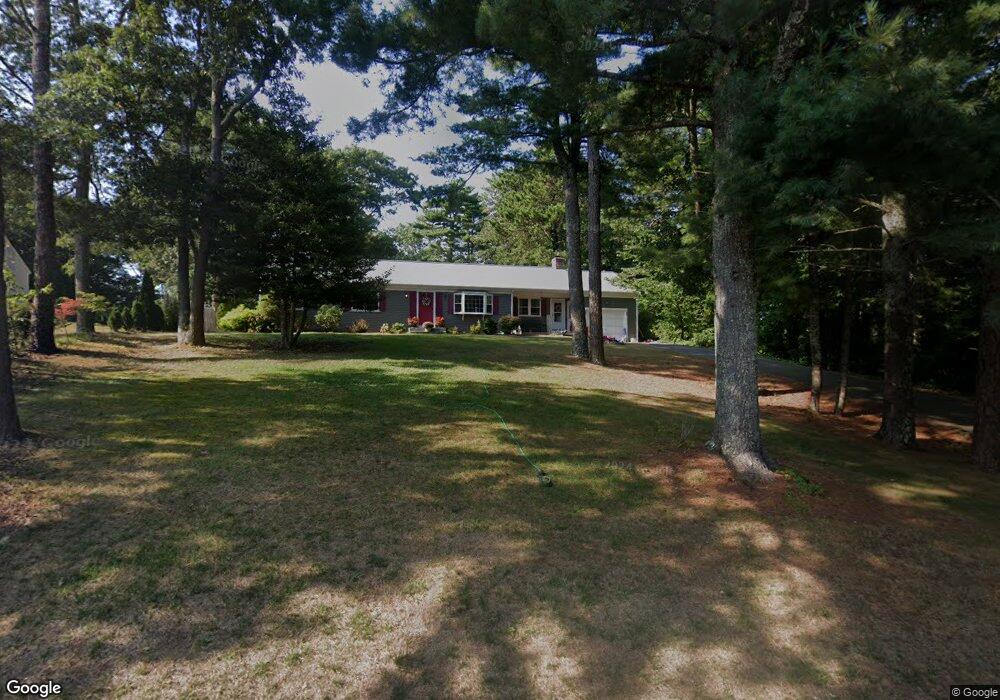
52 Carrie Lees Way Centerville, MA 02632
Centerville NeighborhoodEstimated Value: $642,000 - $668,106
3
Beds
2
Baths
1,556
Sq Ft
$419/Sq Ft
Est. Value
About This Home
This home is located at 52 Carrie Lees Way, Centerville, MA 02632 and is currently estimated at $651,369, approximately $418 per square foot. 52 Carrie Lees Way is a home located in Barnstable County with nearby schools including Centerville Elementary School, Barnstable United Elementary School, and Barnstable Intermediate School.
Ownership History
Date
Name
Owned For
Owner Type
Purchase Details
Closed on
Dec 5, 2019
Sold by
Rogers James M
Bought by
Rogers James R and Rogers Amanda L
Current Estimated Value
Home Financials for this Owner
Home Financials are based on the most recent Mortgage that was taken out on this home.
Original Mortgage
$280,000
Outstanding Balance
$246,328
Interest Rate
3.6%
Mortgage Type
New Conventional
Estimated Equity
$405,041
Create a Home Valuation Report for This Property
The Home Valuation Report is an in-depth analysis detailing your home's value as well as a comparison with similar homes in the area
Home Values in the Area
Average Home Value in this Area
Purchase History
| Date | Buyer | Sale Price | Title Company |
|---|---|---|---|
| Rogers James R | $350,000 | None Available | |
| Rogers James R | $350,000 | None Available |
Source: Public Records
Mortgage History
| Date | Status | Borrower | Loan Amount |
|---|---|---|---|
| Open | Rogers James R | $280,000 | |
| Closed | Rogers James R | $280,000 |
Source: Public Records
Tax History
| Year | Tax Paid | Tax Assessment Tax Assessment Total Assessment is a certain percentage of the fair market value that is determined by local assessors to be the total taxable value of land and additions on the property. | Land | Improvement |
|---|---|---|---|---|
| 2025 | $4,828 | $596,800 | $190,700 | $406,100 |
| 2024 | $4,595 | $588,400 | $190,700 | $397,700 |
| 2023 | $4,472 | $536,200 | $188,400 | $347,800 |
| 2022 | $4,199 | $435,600 | $134,000 | $301,600 |
| 2021 | $4,028 | $384,000 | $134,000 | $250,000 |
| 2020 | $4,140 | $377,700 | $134,000 | $243,700 |
| 2019 | $3,965 | $351,500 | $134,000 | $217,500 |
| 2018 | $3,714 | $331,000 | $146,900 | $184,100 |
| 2017 | $3,469 | $322,400 | $146,900 | $175,500 |
| 2016 | $3,484 | $319,600 | $144,100 | $175,500 |
| 2015 | $3,400 | $313,400 | $145,500 | $167,900 |
Source: Public Records
Map
Nearby Homes
- 200 Lumbert Mill Rd
- 51 Larch Ln
- 53 Meadow Farm Rd
- 52 Meadow Farm Rd
- 103 Pine Tree Dr
- 351 Swift Ave
- 7 Ebenezer
- 315 Prince Hinckley Rd
- 369 Bumps River Rd
- 12 S Cedar Rd
- 296 Buckskin Path
- 89 Swift Ave
- 818 S Main St
- 117 Parsley Ln
- 19 Marrick Ct
- 82 Yacht Club Rd
- 156 S Main St
- 40 Waterfield Rd
- 40 Sachem Dr
- 87 Foxglove Rd
- 42 Carrie Lees Way
- 60 Carrie Lees Way
- 42 Carrie Lee's Way
- 218 Five Corners Rd
- 70 Carrie Lees Way
- 32 Carrie Lees Way
- 208 Five Corners Rd
- 218 5 Corners Rd
- 208 5 Corners Rd
- 51 Carrie Lees Way
- 228 Five Corners Rd
- 198 5 Corners Rd
- 74 Carrie Lees Way
- 41 Carrie Lees Way
- 240 Five Corners Rd
- 240 5 Corners Rd
- 198 Five Corners Rd
- 67 Carrie Lees Way
- 24 Carrie Lees Way
- 31 Carrie Lees Way
Your Personal Tour Guide
Ask me questions while you tour the home.