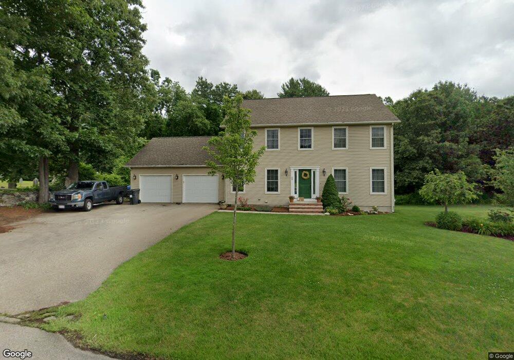
52 Dwinell Rd Millbury, MA 01527
Estimated Value: $699,311 - $751,000
4
Beds
3
Baths
2,346
Sq Ft
$313/Sq Ft
Est. Value
About This Home
This home is located at 52 Dwinell Rd, Millbury, MA 01527 and is currently estimated at $734,578, approximately $313 per square foot. 52 Dwinell Rd is a home located in Worcester County with nearby schools including Elmwood Street Elementary School, Raymond E. Shaw Elementary School, and Millbury Junior/Senior High School.
Ownership History
Date
Name
Owned For
Owner Type
Purchase Details
Closed on
Nov 22, 2005
Sold by
Carroll Dev Corp
Bought by
Kennedy Lilly T and Kennedy Patrick J
Current Estimated Value
Home Financials for this Owner
Home Financials are based on the most recent Mortgage that was taken out on this home.
Original Mortgage
$138,750
Outstanding Balance
$76,163
Interest Rate
6.07%
Mortgage Type
Purchase Money Mortgage
Estimated Equity
$658,415
Create a Home Valuation Report for This Property
The Home Valuation Report is an in-depth analysis detailing your home's value as well as a comparison with similar homes in the area
Home Values in the Area
Average Home Value in this Area
Purchase History
| Date | Buyer | Sale Price | Title Company |
|---|---|---|---|
| Kennedy Lilly T | $185,000 | -- |
Source: Public Records
Mortgage History
| Date | Status | Borrower | Loan Amount |
|---|---|---|---|
| Open | Kennedy Lilly T | $138,750 |
Source: Public Records
Tax History Compared to Growth
Tax History
| Year | Tax Paid | Tax Assessment Tax Assessment Total Assessment is a certain percentage of the fair market value that is determined by local assessors to be the total taxable value of land and additions on the property. | Land | Improvement |
|---|---|---|---|---|
| 2025 | $8,953 | $668,600 | $162,800 | $505,800 |
| 2024 | $8,213 | $620,800 | $150,800 | $470,000 |
| 2023 | $7,448 | $515,400 | $101,500 | $413,900 |
| 2022 | $6,732 | $448,800 | $101,500 | $347,300 |
| 2021 | $6,646 | $430,700 | $101,500 | $329,200 |
| 2020 | $6,509 | $424,600 | $101,500 | $323,100 |
| 2019 | $6,335 | $399,700 | $88,300 | $311,400 |
| 2018 | $3,972 | $399,900 | $103,700 | $296,200 |
| 2017 | $6,117 | $372,300 | $103,700 | $268,600 |
| 2016 | $6,214 | $377,500 | $103,700 | $273,800 |
| 2015 | $6,108 | $371,100 | $110,200 | $260,900 |
| 2014 | $5,693 | $332,900 | $106,100 | $226,800 |
Source: Public Records
Map
Nearby Homes
- 557 SW Cutoff Unit 35
- 557 SW Cutoff Unit 17
- 0 Auburn Rd
- 36 Jade Hill Rd
- 0 Worcester Providence Turnpike
- 47 Washington St Unit 47
- 2 Breezy Bend
- 15 Clearview Terrace Unit 68
- 39 Johnson St
- 32 Horne Way
- 57 Horne Way Unit 57
- 192 Horne Way Unit 192
- 38 W Main St
- 2 Mystic St
- 28 Brierly Cir
- 18 Lincoln Ave
- 37-39 Main St
- 2 Victoria Dr Unit 1
- 7 Canal St
- 62 School St
- Lot B Dwinell Rd
- 55 Dwinell Rd
- 53 Dwinell Rd
- 50 Dwinell Rd
- 71 & 73 Mccracken Rd
- 71 Mccracken Rd
- 65 Mccracken Rd
- 67 Mccracken Rd
- 69 Mccracken Rd
- 0 Dwinell Rd
- B Dwinell Rd
- A Dwinell Rd
- 68 Mccracken Rd
- 73 Mccracken Rd
- 73 Mccracken Rd
- 62 Mccracken Rd
- 73 Mccracken Rd
- 59 Mccracken Rd
- 58 Mccracken Rd
- 57 Mccracken Rd