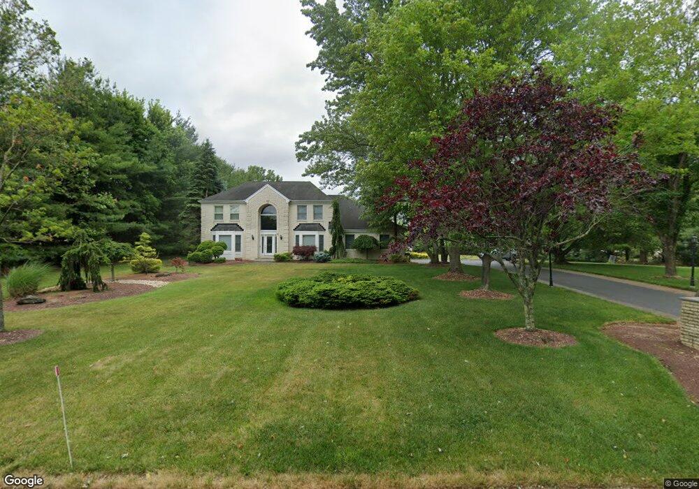
52 Joseph St Manalapan, NJ 07726
Estimated Value: $1,072,000 - $1,173,000
4
Beds
4
Baths
3,226
Sq Ft
$351/Sq Ft
Est. Value
About This Home
This home is located at 52 Joseph St, Manalapan, NJ 07726 and is currently estimated at $1,133,291, approximately $351 per square foot. 52 Joseph St is a home located in Monmouth County with nearby schools including Wemrock Brook School, Manalapan-Englishtown Middle School, and Pine Brook Elementary School.
Ownership History
Date
Name
Owned For
Owner Type
Purchase Details
Closed on
May 31, 2005
Sold by
Singer Ian
Bought by
Schatz Douglas and Faktor Stacy
Current Estimated Value
Home Financials for this Owner
Home Financials are based on the most recent Mortgage that was taken out on this home.
Original Mortgage
$310,000
Interest Rate
6.33%
Mortgage Type
New Conventional
Create a Home Valuation Report for This Property
The Home Valuation Report is an in-depth analysis detailing your home's value as well as a comparison with similar homes in the area
Home Values in the Area
Average Home Value in this Area
Purchase History
| Date | Buyer | Sale Price | Title Company |
|---|---|---|---|
| Schatz Douglas | $655,000 | -- |
Source: Public Records
Mortgage History
| Date | Status | Borrower | Loan Amount |
|---|---|---|---|
| Previous Owner | Schatz Douglas | $310,000 |
Source: Public Records
Tax History Compared to Growth
Tax History
| Year | Tax Paid | Tax Assessment Tax Assessment Total Assessment is a certain percentage of the fair market value that is determined by local assessors to be the total taxable value of land and additions on the property. | Land | Improvement |
|---|---|---|---|---|
| 2025 | $15,092 | $1,030,300 | $414,800 | $615,500 |
| 2024 | $14,664 | $894,100 | $367,800 | $526,300 |
| 2023 | $14,664 | $881,800 | $367,800 | $514,000 |
| 2022 | $12,792 | $773,600 | $282,800 | $490,800 |
| 2021 | $12,792 | $614,400 | $177,800 | $436,600 |
| 2020 | $12,811 | $621,900 | $187,800 | $434,100 |
| 2019 | $13,090 | $634,500 | $210,300 | $424,200 |
| 2018 | $12,257 | $590,400 | $159,300 | $431,100 |
| 2017 | $12,323 | $593,900 | $177,800 | $416,100 |
| 2016 | $12,295 | $598,600 | $187,800 | $410,800 |
| 2015 | $12,207 | $588,000 | $187,800 | $400,200 |
| 2014 | $12,314 | $578,100 | $175,800 | $402,300 |
Source: Public Records
Map
Nearby Homes
- 5 Summit Ave
- 158 Sweetmans Ln Unit 1
- 13 Woodward Rd
- 5 Darlington Dr
- 226 Smithburg Rd
- 6 Hillcrest Rd
- 40 Highland Ridge Rd
- 19 Roberts Rd
- 18 Hartack Rd
- 22 Silver Charm Rd
- 8 Pittenger Ct
- 1713 Melrose Blvd Unit 1703
- 1913 Melrose Blvd Unit 1903
- 1914 Melrose Blvd Unit 1904
- 1311 Auburn Terrace Unit 1301
- 1315 Auburn Terrace Unit 1305
- 1911 Melrose Blvd Unit 1901
- 1312 Auburn Terrace Unit 1302
- 1912 Melrose Blvd Unit 1902
- 1411 Melrose Blvd Unit 1401
- 1 Woodward Rd
- 3 Christie Ct
- 2 Christie Ct
- 153 Sweetmans Ln
- 153 Sweetmans Ln Unit 2
- 153 Sweetmans Ln Unit Lot 2.04
- 153 Sweetmans Ln Unit Lot 2.03
- 153 Sweetmans Ln Unit Lot 2.02
- 153 Sweetmans Ln Unit Lot 2.01
- 148 Sweetmans Ln
- 51 Joseph St
- 146 Sweetmans Ln
- 152 Sweetmans Ln
- 3 Woodward Rd
- 5 Christie Ct
- 154 Sweetmans Ln
- 144 Sweetmans Ln
- 4 Christie Ct
- 4 Woodward Rd
- 5 Woodward Rd