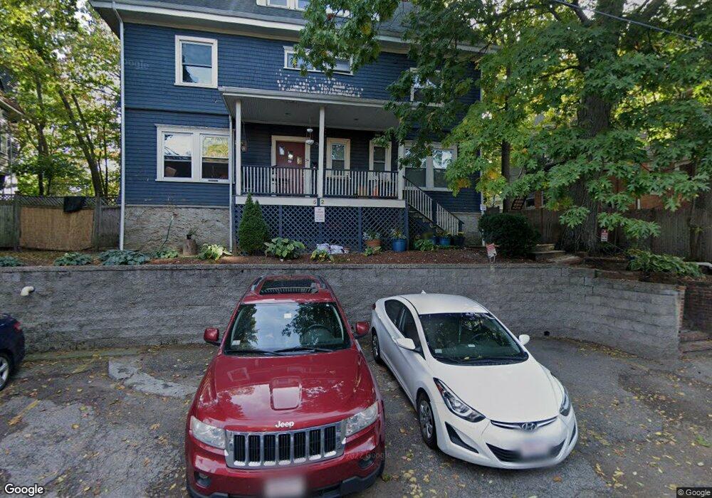
52 Lanark Rd Brighton, MA 02135
Commonwealth NeighborhoodEstimated Value: $2,146,000 - $2,511,071
5
Beds
4
Baths
3,535
Sq Ft
$650/Sq Ft
Est. Value
About This Home
This home is located at 52 Lanark Rd, Brighton, MA 02135 and is currently estimated at $2,296,268, approximately $649 per square foot. 52 Lanark Rd is a home located in Suffolk County with nearby schools including Torah Academy, Shaloh House Jewish Day School, and Bais Yaakov Of Boston High School.
Ownership History
Date
Name
Owned For
Owner Type
Purchase Details
Closed on
Aug 30, 2013
Sold by
52 Lanarak Road Rt
Bought by
Wang Tao and Wang Xuejiao
Current Estimated Value
Home Financials for this Owner
Home Financials are based on the most recent Mortgage that was taken out on this home.
Original Mortgage
$847,000
Outstanding Balance
$632,059
Interest Rate
4.4%
Mortgage Type
Purchase Money Mortgage
Estimated Equity
$1,664,209
Purchase Details
Closed on
Aug 29, 2012
Sold by
Zuber Jacob I and Zuber Chana K
Bought by
52 Lanark Road Rt
Home Financials for this Owner
Home Financials are based on the most recent Mortgage that was taken out on this home.
Original Mortgage
$685,000
Interest Rate
3.56%
Mortgage Type
Purchase Money Mortgage
Create a Home Valuation Report for This Property
The Home Valuation Report is an in-depth analysis detailing your home's value as well as a comparison with similar homes in the area
Home Values in the Area
Average Home Value in this Area
Purchase History
| Date | Buyer | Sale Price | Title Company |
|---|---|---|---|
| Wang Tao | $1,210,000 | -- | |
| Wang Tao | $1,210,000 | -- | |
| 52 Lanark Road Rt | $820,000 | -- |
Source: Public Records
Mortgage History
| Date | Status | Borrower | Loan Amount |
|---|---|---|---|
| Open | Wang Tao | $847,000 | |
| Closed | Wang Tao | $847,000 | |
| Previous Owner | 52 Lanark Road Rt | $685,000 |
Source: Public Records
Tax History
| Year | Tax Paid | Tax Assessment Tax Assessment Total Assessment is a certain percentage of the fair market value that is determined by local assessors to be the total taxable value of land and additions on the property. | Land | Improvement |
|---|---|---|---|---|
| 2025 | $21,064 | $1,819,000 | $776,000 | $1,043,000 |
| 2024 | $19,306 | $1,771,200 | $674,100 | $1,097,100 |
| 2023 | $18,109 | $1,686,100 | $641,700 | $1,044,400 |
| 2022 | $18,166 | $1,669,700 | $635,500 | $1,034,200 |
| 2021 | $17,467 | $1,637,000 | $623,000 | $1,014,000 |
| 2020 | $17,233 | $1,631,900 | $592,600 | $1,039,300 |
| 2019 | $16,081 | $1,525,700 | $448,600 | $1,077,100 |
| 2018 | $15,225 | $1,452,800 | $448,600 | $1,004,200 |
| 2017 | $14,652 | $1,383,600 | $448,600 | $935,000 |
| 2016 | $13,592 | $1,235,600 | $448,600 | $787,000 |
| 2015 | $12,267 | $1,013,000 | $297,400 | $715,600 |
| 2014 | $10,426 | $828,800 | $297,400 | $531,400 |
Source: Public Records
Map
Nearby Homes
- 15 Colliston Rd Unit 6
- 140 Kilsyth Rd Unit 8
- 100 Lanark Rd Unit A
- 100 Lanark Rd Unit 8
- 36 Cummings Rd Unit 1
- 24 Selkirk Rd Unit 24-4
- 1691 Commonwealth Ave Unit 31
- 30 Kinross Rd Unit 1
- 8 Kinross Rd Unit 2
- 47 Englewood Ave
- 38 Ransom Rd Unit 12
- 1754 Commonwealth Ave Unit B
- 32 Ransom Rd Unit 4
- 56-58 Selkirk Rd
- 1641 Commonwealth Ave Unit 16
- 60 Sutherland Rd Unit 4
- 4 7 Englewood Ave
- 113-115 Nottinghill Rd
- 22 Windsor Rd
- 123 Nottinghill Rd Unit 1
- 52 Lanark Rd
- 52 Lanark Rd Unit 1
- 52 Lanark Rd Unit 2
- 48 Lanark Rd
- 48 Lanark Rd
- 48 Lanark Rd Unit 2
- 48 Lanark Rd Unit 1
- 126 Kilsyth Rd Unit 4
- 126 Kilsyth Rd Unit 3
- 126 Kilsyth Rd Unit 2
- 132 Kilsyth Rd
- 132 Kilsyth Rd Unit 3A
- 132 Kilsyth Rd
- 132 Kilsyth Rd Unit 132
- 132 Kilsyth Rd Unit 2
- 59 Lanark Rd Unit 12
- 59 Lanark Rd Unit 11
- 59 Lanark Rd Unit 10
- 59 Lanark Rd Unit 9
- 59 Lanark Rd Unit 8
Your Personal Tour Guide
Ask me questions while you tour the home.