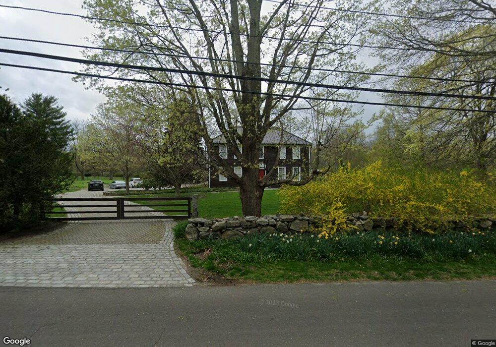
52 Locust Rd Greenwich, CT 06831
Back Country Greenwich NeighborhoodEstimated Value: $2,361,101 - $2,577,000
3
Beds
4
Baths
3,120
Sq Ft
$791/Sq Ft
Est. Value
About This Home
This home is located at 52 Locust Rd, Greenwich, CT 06831 and is currently estimated at $2,468,034, approximately $791 per square foot. 52 Locust Rd is a home located in Fairfield County with nearby schools including Parkway School, Western Middle School, and Greenwich High School.
Ownership History
Date
Name
Owned For
Owner Type
Purchase Details
Closed on
Aug 15, 2024
Sold by
52 Locust Rd Llc
Bought by
52 Locust Rd Llc
Current Estimated Value
Purchase Details
Closed on
Aug 14, 2020
Sold by
Obrig Tom G
Bought by
52 Locust Road Llc
Purchase Details
Closed on
Mar 27, 2017
Sold by
Delson Ingrid and -Mcmenamin Stephen
Bought by
52 Locust Road Llc
Purchase Details
Closed on
May 12, 1997
Sold by
Miller Harold Est
Bought by
Delson Ingrid and Mcmenamin Stephen
Home Financials for this Owner
Home Financials are based on the most recent Mortgage that was taken out on this home.
Original Mortgage
$598,400
Interest Rate
7.25%
Mortgage Type
Unknown
Create a Home Valuation Report for This Property
The Home Valuation Report is an in-depth analysis detailing your home's value as well as a comparison with similar homes in the area
Home Values in the Area
Average Home Value in this Area
Purchase History
| Date | Buyer | Sale Price | Title Company |
|---|---|---|---|
| 52 Locust Rd Llc | -- | None Available | |
| 52 Locust Rd Llc | -- | None Available | |
| 52 Locust Rd Llc | -- | None Available | |
| 52 Locust Road Llc | $180,000 | None Available | |
| 52 Locust Road Llc | $180,000 | None Available | |
| 52 Locust Road Llc | $180,000 | None Available | |
| 52 Locust Road Llc | -- | -- | |
| 52 Locust Road Llc | -- | -- | |
| Delson Ingrid | $320,000 | -- | |
| 52 Locust Road Llc | -- | -- | |
| Delson Ingrid | $320,000 | -- |
Source: Public Records
Mortgage History
| Date | Status | Borrower | Loan Amount |
|---|---|---|---|
| Previous Owner | Delson Ingrid | $710,000 | |
| Previous Owner | Delson Ingrid | $745,000 | |
| Previous Owner | Delson Ingrid | $598,400 |
Source: Public Records
Tax History Compared to Growth
Tax History
| Year | Tax Paid | Tax Assessment Tax Assessment Total Assessment is a certain percentage of the fair market value that is determined by local assessors to be the total taxable value of land and additions on the property. | Land | Improvement |
|---|---|---|---|---|
| 2025 | $14,642 | $1,216,110 | $519,120 | $696,990 |
| 2024 | $13,924 | $1,189,090 | $492,100 | $696,990 |
| 2023 | $13,544 | $1,189,090 | $492,100 | $696,990 |
| 2022 | $13,413 | $1,189,090 | $492,100 | $696,990 |
| 2021 | $13,474 | $1,162,560 | $316,540 | $846,020 |
| 2020 | $13,474 | $1,162,560 | $316,540 | $846,020 |
| 2019 | $13,579 | $1,162,560 | $316,540 | $846,020 |
| 2018 | $12,296 | $1,081,430 | $316,540 | $764,890 |
| 2017 | $11,569 | $1,017,520 | $316,540 | $700,980 |
| 2016 | $11,396 | $1,017,520 | $316,540 | $700,980 |
| 2015 | $10,422 | $924,770 | $360,780 | $563,990 |
| 2014 | $10,145 | $924,770 | $360,780 | $563,990 |
Source: Public Records
Map
Nearby Homes
- 32 Locust Rd
- 38 Bedford Rd
- 15 Audubon Ln
- 20 Cutler Rd
- 79 Richmond Hill Rd
- Atkinson Plan at Enclave at Armonk
- Saunders Plan at Enclave at Armonk
- Walters Plan at Enclave at Armonk
- Wilkerson Plan at Enclave at Armonk
- 1 Fieldstone Knoll Unit 47
- 3 Fieldstone Knoll Unit 46
- 9 Fieldstone Knoll
- 3 Fieldstone Knoll
- 11 Fieldstone Knoll
- 176 Bedford Rd
- 8 Fieldstone Knoll Unit 51
- 85 Cutler Rd
- 9 Corrigan Ln
- 71 N Porchuck Rd
- 10 Cliffdale Rd