
Seller's Agent in 2025
Robin Tregenza
Residential Properties Ltd.
(203) 246-6899
3 in this area
76 Total Sales

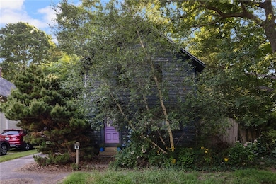
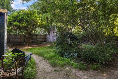
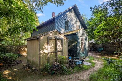
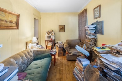
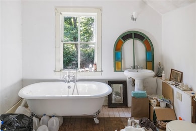
This charming 1885 Colonial offers three bedrooms and two full baths in a prime South Kingstown location, close to everything the area has to offer. Steeped in character, the home features original pine plank flooring, period details, and a brand-new furnace. Just minutes to downtown Wakefield, The Whalers Brewing Company, Jayd Buns, the SK Rec Center, pickleball and summer concerts in the park plus a short drive to South County's beautiful beaches you're truly in the heart of it all. Sited on a 6,100 sq ft fenced lot with perennial gardens, mature trees, and two outbuildings, the yard offers space to relax, garden, or play. This diamond in the rough is surrounded by nature and ready for your vision. A rare opportunity to create your dream home in an unbeatable location. CASH OFFERS ONLY. HIGHEST AND BEST OFFERS DUE BY THURSDAY, JULY 17TH 5:00PM.
Last Agent to Sell the Property
Residential Properties Ltd. License #REB.0019817 Listed on: 06/30/2025
| Date | Type | Sale Price | Title Company |
|---|---|---|---|
| Warranty Deed | $428,000 | -- | |
| Deed | $260,000 | -- | |
| Warranty Deed | $103,000 | -- |
| Date | Status | Loan Amount | Loan Type |
|---|---|---|---|
| Previous Owner | $195,000 | Purchase Money Mortgage | |
| Previous Owner | $182,750 | No Value Available | |
| Previous Owner | $143,000 | No Value Available | |
| Previous Owner | $110,000 | No Value Available |
| Date | Event | Price | List to Sale | Price per Sq Ft |
|---|---|---|---|---|
| 09/23/2025 09/23/25 | Sold | $428,000 | +14.1% | $357 / Sq Ft |
| 07/18/2025 07/18/25 | Pending | -- | -- | -- |
| 06/30/2025 06/30/25 | For Sale | $375,000 | -- | $313 / Sq Ft |
| Year | Tax Paid | Tax Assessment Tax Assessment Total Assessment is a certain percentage of the fair market value that is determined by local assessors to be the total taxable value of land and additions on the property. | Land | Improvement |
|---|---|---|---|---|
| 2025 | $3,298 | $368,900 | $156,700 | $212,200 |
| 2024 | $3,227 | $292,000 | $120,500 | $171,500 |
| 2023 | $3,227 | $292,000 | $120,500 | $171,500 |
| 2022 | $3,197 | $292,000 | $120,500 | $171,500 |
| 2021 | $3,302 | $228,500 | $104,800 | $123,700 |
| 2020 | $3,302 | $228,500 | $104,800 | $123,700 |
| 2019 | $3,302 | $228,500 | $104,800 | $123,700 |
| 2018 | $3,127 | $199,400 | $97,500 | $101,900 |
| 2017 | $3,053 | $199,400 | $97,500 | $101,900 |
| 2016 | $3,009 | $199,400 | $97,500 | $101,900 |
| 2015 | $2,991 | $192,700 | $95,300 | $97,400 |
| 2014 | $2,983 | $192,700 | $95,300 | $97,400 |
Seller's Agent in 2025
Robin Tregenza
Residential Properties Ltd.
(203) 246-6899
3 in this area
76 Total Sales
Buyer's Agent in 2025
Petra Laurie
Residential Properties Ltd.
(401) 338-6400
1 in this area
26 Total Sales
Source: State-Wide MLS
MLS Number: 1389044
APN: SKIN-004904-000000-000126
Disclaimer: Certain information contained herein is derived from information provided by parties other than Homes.com. All information provided is deemed reliable, but is not guaranteed to be accurate and should be independently verified.
![]() IDX information is provided exclusively for personal, non-commercial use, and may not be used for any purpose other than to identify prospective properties consumers may be interested in purchasing. Information is deemed reliable but not guaranteed.
IDX information is provided exclusively for personal, non-commercial use, and may not be used for any purpose other than to identify prospective properties consumers may be interested in purchasing. Information is deemed reliable but not guaranteed.
Copyright © 2026 State-Wide MLS, Inc. All rights reserved.
Ask me questions while you tour the home.