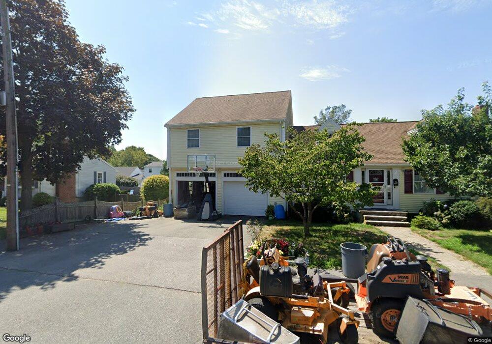
52 Willow St Braintree, MA 02184
East Braintree NeighborhoodEstimated Value: $729,000 - $882,000
3
Beds
2
Baths
2,496
Sq Ft
$318/Sq Ft
Est. Value
About This Home
This home is located at 52 Willow St, Braintree, MA 02184 and is currently estimated at $794,388, approximately $318 per square foot. 52 Willow St is a home located in Norfolk County with nearby schools including Braintree High School, Sacred Heart Elementary School, and Step Ahead Kindergarten.
Ownership History
Date
Name
Owned For
Owner Type
Purchase Details
Closed on
Jun 19, 2007
Sold by
Grace Thomas
Bought by
Grace Jeannine L and Grace Thomas
Current Estimated Value
Purchase Details
Closed on
Jul 17, 1992
Sold by
Grace Donna M
Bought by
Grace Thomas
Home Financials for this Owner
Home Financials are based on the most recent Mortgage that was taken out on this home.
Original Mortgage
$103,900
Interest Rate
8.54%
Mortgage Type
Purchase Money Mortgage
Create a Home Valuation Report for This Property
The Home Valuation Report is an in-depth analysis detailing your home's value as well as a comparison with similar homes in the area
Home Values in the Area
Average Home Value in this Area
Purchase History
| Date | Buyer | Sale Price | Title Company |
|---|---|---|---|
| Grace Jeannine L | -- | -- | |
| Grace Thomas | $129,900 | -- |
Source: Public Records
Mortgage History
| Date | Status | Borrower | Loan Amount |
|---|---|---|---|
| Previous Owner | Grace Thomas | $52,000 | |
| Previous Owner | Grace Thomas | $108,300 | |
| Previous Owner | Grace Thomas | $103,900 |
Source: Public Records
Tax History
| Year | Tax Paid | Tax Assessment Tax Assessment Total Assessment is a certain percentage of the fair market value that is determined by local assessors to be the total taxable value of land and additions on the property. | Land | Improvement |
|---|---|---|---|---|
| 2025 | $7,044 | $705,800 | $337,400 | $368,400 |
| 2024 | $6,401 | $675,200 | $314,600 | $360,600 |
| 2023 | $6,087 | $623,700 | $282,700 | $341,000 |
| 2022 | $5,934 | $596,400 | $255,400 | $341,000 |
| 2021 | $5,396 | $542,300 | $230,700 | $311,600 |
| 2020 | $5,141 | $521,400 | $209,800 | $311,600 |
| 2019 | $4,957 | $491,300 | $200,600 | $290,700 |
| 2018 | $4,863 | $461,400 | $182,400 | $279,000 |
| 2017 | $4,731 | $440,500 | $173,300 | $267,200 |
| 2016 | $4,449 | $405,200 | $145,900 | $259,300 |
| 2015 | $4,357 | $393,600 | $144,100 | $249,500 |
| 2014 | $4,125 | $361,200 | $131,300 | $229,900 |
Source: Public Records
Map
Nearby Homes
- 18 Hobart St
- 300 Commercial St Unit 23
- 599 Union St
- 14 Hillside Rd
- 140 Commercial St
- 41 Lantern Ln
- 37 Lantern Ln
- 54 Edgemont Rd
- 82 Cotton Ave
- 30 Skyline Dr Unit 6
- 37 Skyline Dr Unit 11
- 36 Chestnut Ave
- 25 W Howard St Unit C3
- 67 Trefton Dr
- 15 Bower Rd Unit F9
- 87 Arborway Dr
- 38 Stonewood Ln
- 17 White Rd
- 25 Richmond St
- 149 Glenrose Ave
Your Personal Tour Guide
Ask me questions while you tour the home.