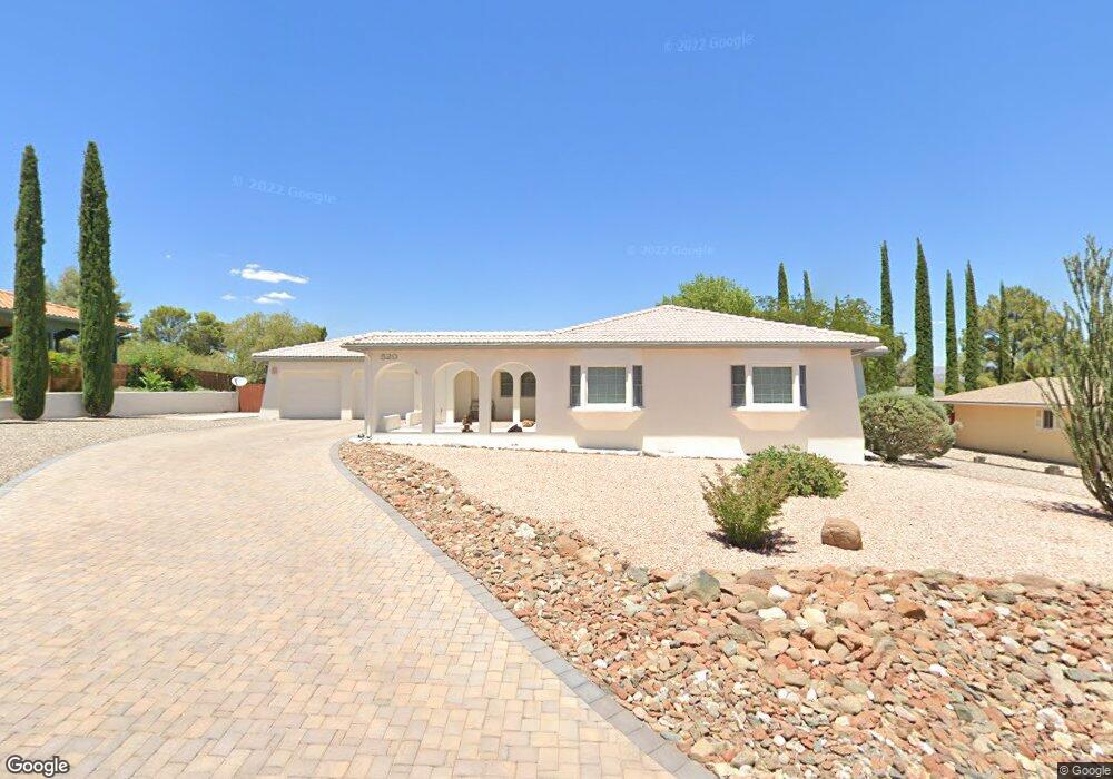
520 Ami Ln Clarkdale, AZ 86324
Estimated Value: $437,747 - $579,000
--
Bed
--
Bath
1,739
Sq Ft
$286/Sq Ft
Est. Value
About This Home
This home is located at 520 Ami Ln, Clarkdale, AZ 86324 and is currently estimated at $496,687, approximately $285 per square foot. 520 Ami Ln is a home located in Yavapai County with nearby schools including Cottonwood Elementary School, Dr Daniel Bright Elementary School, and Cottonwood Community School.
Ownership History
Date
Name
Owned For
Owner Type
Purchase Details
Closed on
Jan 29, 2013
Sold by
Forbes W Eldon and Forbes Marylou
Bought by
Forbes W Eldon and Forbes Marylou
Current Estimated Value
Purchase Details
Closed on
May 4, 1999
Sold by
Forbes W Eldon and Forbes Marylou
Bought by
Forbes W Eldon and Forbes Marylou
Purchase Details
Closed on
Sep 26, 1994
Sold by
Morrison John R and Morrison Naomi R
Bought by
Forbes Woodrow Eldon and Forbes Mary Lou
Purchase Details
Closed on
Feb 8, 1994
Sold by
Norton Duane B and Norton Patricia D
Bought by
Morrison John R and Morrison Naomi R
Create a Home Valuation Report for This Property
The Home Valuation Report is an in-depth analysis detailing your home's value as well as a comparison with similar homes in the area
Home Values in the Area
Average Home Value in this Area
Purchase History
| Date | Buyer | Sale Price | Title Company |
|---|---|---|---|
| Forbes W Eldon | -- | None Available | |
| Forbes W Eldon | -- | -- | |
| Forbes Woodrow Eldon | $37,000 | Capital Title Agency | |
| Morrison John R | $35,000 | Capital Title Agency |
Source: Public Records
Tax History Compared to Growth
Tax History
| Year | Tax Paid | Tax Assessment Tax Assessment Total Assessment is a certain percentage of the fair market value that is determined by local assessors to be the total taxable value of land and additions on the property. | Land | Improvement |
|---|---|---|---|---|
| 2026 | $2,728 | $41,325 | -- | -- |
| 2024 | $2,635 | $40,915 | -- | -- |
| 2023 | $2,635 | $31,714 | $4,759 | $26,955 |
| 2022 | $2,593 | $24,435 | $3,833 | $20,602 |
| 2021 | $2,690 | $22,762 | $3,880 | $18,882 |
| 2020 | $2,642 | $0 | $0 | $0 |
| 2019 | $2,592 | $0 | $0 | $0 |
| 2018 | $2,490 | $0 | $0 | $0 |
| 2017 | $2,383 | $0 | $0 | $0 |
| 2016 | $2,328 | $0 | $0 | $0 |
| 2015 | $2,290 | $0 | $0 | $0 |
| 2014 | $2,094 | $0 | $0 | $0 |
Source: Public Records
Map
Nearby Homes
- 2101 Canyon Dr
- 421 Casner Dr
- 621 Skyline Blvd Unit 48
- 661 Skyline Blvd Unit 44
- 671 Skyline Blvd Unit 43
- 240 Rogers Place
- 1985 Roadrunner Ct
- 661 Shadow Canyon Dr
- 222 Rogers Place
- 1941 Sable Ridge Rd Unit 156
- 1941 Crossroads Blvd
- 641 Pine Ridge Rd Unit 159
- 440 Skyline Blvd
- 1830 W Trail Blazer Dr
- 235 S Cowboy Way
- 1910 W Trail Blazer Dr
- 1869 W Trail Blazer Dr
- 1780 Buena Vista Dr
- 15 Alamos Dr Unit A & B
- 265 S Latigo Way