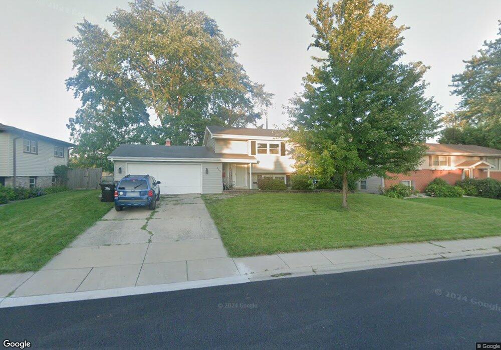
520 Brown St Wauconda, IL 60084
Estimated Value: $266,650 - $382,000
3
Beds
2
Baths
920
Sq Ft
$346/Sq Ft
Est. Value
About This Home
This home is located at 520 Brown St, Wauconda, IL 60084 and is currently estimated at $318,413, approximately $346 per square foot. 520 Brown St is a home located in Lake County with nearby schools including Wauconda Grade School, Wauconda Middle School, and Wauconda High School.
Ownership History
Date
Name
Owned For
Owner Type
Purchase Details
Closed on
Jun 13, 2018
Sold by
Thompson Gary and Thompson Cheryl
Bought by
Harris Dana
Current Estimated Value
Home Financials for this Owner
Home Financials are based on the most recent Mortgage that was taken out on this home.
Original Mortgage
$171,000
Outstanding Balance
$148,283
Interest Rate
4.62%
Mortgage Type
New Conventional
Estimated Equity
$170,130
Create a Home Valuation Report for This Property
The Home Valuation Report is an in-depth analysis detailing your home's value as well as a comparison with similar homes in the area
Home Values in the Area
Average Home Value in this Area
Purchase History
| Date | Buyer | Sale Price | Title Company |
|---|---|---|---|
| Harris Dana | $190,000 | Old Republic Title |
Source: Public Records
Mortgage History
| Date | Status | Borrower | Loan Amount |
|---|---|---|---|
| Open | Harris Dana | $171,000 |
Source: Public Records
Tax History Compared to Growth
Tax History
| Year | Tax Paid | Tax Assessment Tax Assessment Total Assessment is a certain percentage of the fair market value that is determined by local assessors to be the total taxable value of land and additions on the property. | Land | Improvement |
|---|---|---|---|---|
| 2024 | $4,094 | $65,198 | $19,996 | $45,202 |
| 2023 | $5,931 | $49,663 | $15,231 | $34,432 |
| 2022 | $5,931 | $60,355 | $17,422 | $42,933 |
| 2021 | $5,054 | $51,661 | $16,462 | $35,199 |
| 2020 | $4,879 | $49,238 | $15,690 | $33,548 |
| 2019 | $4,322 | $46,534 | $14,828 | $31,706 |
| 2018 | $5,222 | $56,382 | $18,265 | $38,117 |
| 2017 | $5,204 | $55,730 | $18,054 | $37,676 |
| 2016 | $4,842 | $52,775 | $17,097 | $35,678 |
| 2015 | $5,076 | $48,448 | $15,695 | $32,753 |
| 2014 | $4,350 | $43,997 | $17,934 | $26,063 |
| 2012 | $4,259 | $43,258 | $17,159 | $26,099 |
Source: Public Records
Map
Nearby Homes
- 532 Brown St
- 225 Larkdale Row
- 240 Regency Ct
- 235 Regency Ct Unit B
- 225 Regency Ct Unit A
- 136 Parkview Dr Unit 5136
- 450 N Main St Unit S307A
- 450 N Main St Unit S208A
- 845 Osage Terrace
- 335 Farmhill Cir
- 311 Brown St
- 26049 N Il Route 59
- 26241 W Bonner Rd
- 136 Hubbard Ct
- 28177 N Garland Rd
- 26036 Illinois Route 59
- 651 W Liberty St Unit B
- 131 E Mill St Unit B104
- 226 Barrington Rd
- 318 E Liberty St