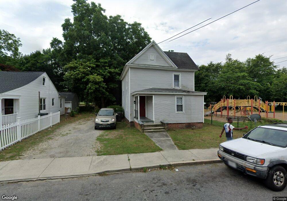
520 E William St Salisbury, MD 21804
Church Street-Doverdale NeighborhoodEstimated Value: $127,000 - $204,000
Studio
1
Bath
1,204
Sq Ft
$138/Sq Ft
Est. Value
About This Home
This home is located at 520 E William St, Salisbury, MD 21804 and is currently estimated at $165,791, approximately $137 per square foot. 520 E William St is a home located in Wicomico County with nearby schools including Beaver Run Elementary School, East Salisbury Elementary School, and Wicomico Middle School.
Ownership History
Date
Name
Owned For
Owner Type
Purchase Details
Closed on
Nov 18, 2002
Sold by
Chandler Gary L
Bought by
L B Llc
Current Estimated Value
Purchase Details
Closed on
Jul 17, 1991
Sold by
Shaver Billie R
Bought by
Chandler Gary L
Purchase Details
Closed on
Oct 31, 1986
Sold by
Shaver Janet Lee
Bought by
Shaver Billie R
Home Financials for this Owner
Home Financials are based on the most recent Mortgage that was taken out on this home.
Original Mortgage
$17,000
Interest Rate
9.89%
Create a Home Valuation Report for This Property
The Home Valuation Report is an in-depth analysis detailing your home's value as well as a comparison with similar homes in the area
Home Values in the Area
Average Home Value in this Area
Purchase History
| Date | Buyer | Sale Price | Title Company |
|---|---|---|---|
| L B Llc | -- | -- | |
| Chandler Gary L | $22,500 | -- | |
| Shaver Billie R | $15,000 | -- |
Source: Public Records
Mortgage History
| Date | Status | Borrower | Loan Amount |
|---|---|---|---|
| Previous Owner | Shaver Billie R | $17,000 |
Source: Public Records
Tax History
| Year | Tax Paid | Tax Assessment Tax Assessment Total Assessment is a certain percentage of the fair market value that is determined by local assessors to be the total taxable value of land and additions on the property. | Land | Improvement |
|---|---|---|---|---|
| 2025 | $695 | $76,033 | $0 | $0 |
| 2024 | $685 | $71,400 | $8,700 | $62,700 |
| 2023 | $626 | $63,367 | $0 | $0 |
| 2022 | $564 | $55,333 | $0 | $0 |
| 2021 | $484 | $47,300 | $8,700 | $38,600 |
| 2020 | $475 | $46,067 | $0 | $0 |
| 2019 | $469 | $44,833 | $0 | $0 |
| 2018 | $907 | $43,600 | $8,700 | $34,900 |
| 2017 | $869 | $41,733 | $0 | $0 |
| 2016 | -- | $39,867 | $0 | $0 |
| 2015 | $1,044 | $38,000 | $0 | $0 |
| 2014 | $1,044 | $38,000 | $0 | $0 |
Source: Public Records
Map
Nearby Homes
- 410 Elizabeth St
- 411 Elizabeth St
- 711 E Church St
- 309 Gay St
- 304 Poplar Hill Ave
- 201 Marshall St
- 322 Naylor St
- 812 E Church St
- 309 Marshall St
- 810 N Division St
- 309 Park Heights Ave
- 204 Holland Ave
- 208 W Isabella St
- 611 Lakeside Dr
- 722 S Park Dr
- 228 Glen Ave
- 117 Washington St
- 113 Priscilla St Unit 1
- 405 Washington St
- 1214 N Division St
- 516 E William St
- 522 E William St
- 518 E William St
- 524 E William St
- 525 E William St Unit 1
- 531 E William St
- 519 E William St Unit 1
- 527 E William St
- 517 E William St
- 529 E William St
- 526 E William St
- 515 E William St
- 517 Wailes St
- 521 Wailes St
- 519 Wailes St
- 523 Wailes St
- 309 E Railroad Ave
- 309 E Railroad Ave Unit 2
- 309 E Railroad Ave Unit 1
- 515 Wailes St
Your Personal Tour Guide
Ask me questions while you tour the home.