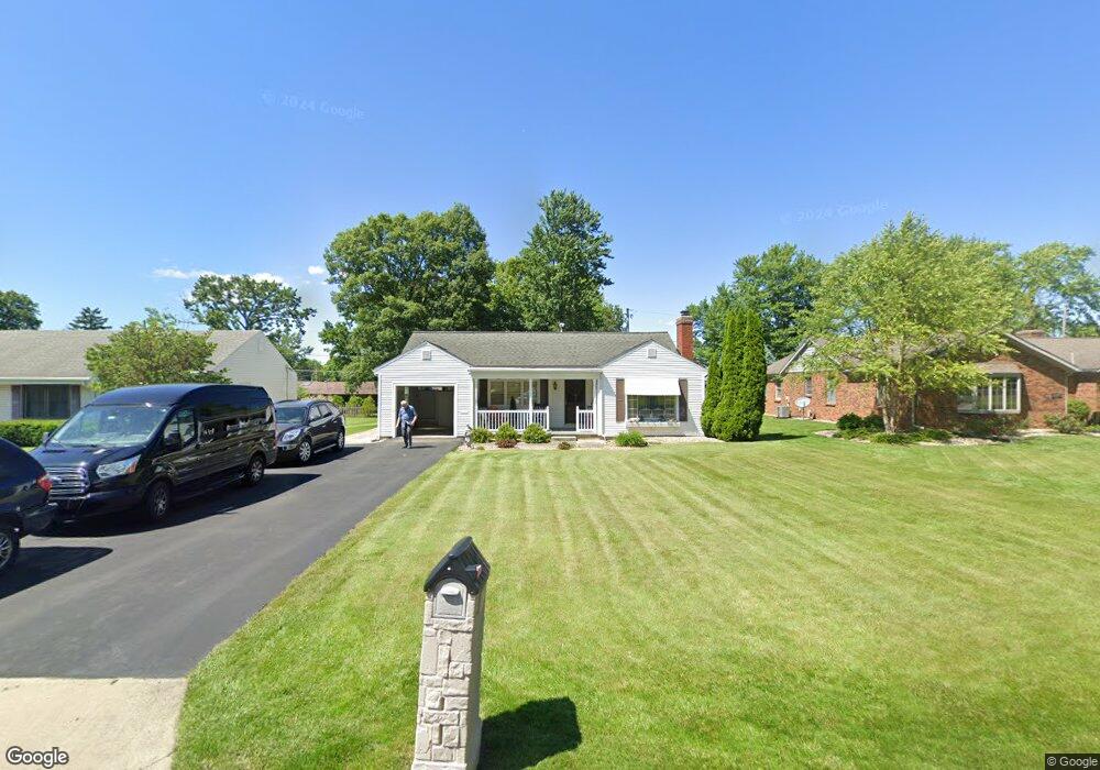
520 Euclid Ave Bucyrus, OH 44820
Estimated Value: $224,721 - $287,000
3
Beds
2
Baths
1,594
Sq Ft
$155/Sq Ft
Est. Value
About This Home
This home is located at 520 Euclid Ave, Bucyrus, OH 44820 and is currently estimated at $247,180, approximately $155 per square foot. 520 Euclid Ave is a home located in Crawford County with nearby schools including Bucyrus Elementary School, Bucyrus Secondary School, and Wayside Christian School.
Ownership History
Date
Name
Owned For
Owner Type
Purchase Details
Closed on
Dec 10, 2021
Sold by
Ballou Samuel A and Ballou Margaret L
Bought by
Showalter Patricia and Showalter Keith
Current Estimated Value
Purchase Details
Closed on
Oct 1, 2021
Sold by
Slj Rentals Ltd
Bought by
Showalter Patricia and Showalter Keith
Purchase Details
Closed on
Apr 3, 2009
Sold by
Jenney Sarah L
Bought by
Slj Rentals Ltd
Purchase Details
Closed on
Mar 9, 2004
Bought by
Slj Rentals Ltd
Purchase Details
Closed on
Oct 6, 2001
Bought by
Jenney Sarah L
Create a Home Valuation Report for This Property
The Home Valuation Report is an in-depth analysis detailing your home's value as well as a comparison with similar homes in the area
Home Values in the Area
Average Home Value in this Area
Purchase History
| Date | Buyer | Sale Price | Title Company |
|---|---|---|---|
| Showalter Patricia | $125 | Acs Title | |
| Showalter Patricia | $165,000 | Acs Title Bucyrus | |
| Slj Rentals Ltd | -- | -- | |
| Slj Rentals Ltd | -- | -- | |
| Jenney Sarah L | -- | -- |
Source: Public Records
Tax History Compared to Growth
Tax History
| Year | Tax Paid | Tax Assessment Tax Assessment Total Assessment is a certain percentage of the fair market value that is determined by local assessors to be the total taxable value of land and additions on the property. | Land | Improvement |
|---|---|---|---|---|
| 2024 | $2,343 | $53,330 | $4,430 | $48,900 |
| 2023 | $2,343 | $36,110 | $4,200 | $31,910 |
| 2022 | $1,877 | $36,110 | $4,200 | $31,910 |
| 2021 | $1,922 | $36,110 | $4,200 | $31,910 |
| 2020 | $1,624 | $28,910 | $4,200 | $24,710 |
| 2019 | $1,660 | $28,910 | $4,200 | $24,710 |
| 2018 | $1,652 | $28,910 | $4,200 | $24,710 |
| 2017 | $1,549 | $26,160 | $4,200 | $21,960 |
| 2016 | $1,502 | $26,160 | $4,200 | $21,960 |
| 2015 | $1,481 | $26,160 | $4,200 | $21,960 |
| 2014 | $1,475 | $26,160 | $4,200 | $21,960 |
| 2013 | $1,475 | $26,160 | $4,200 | $21,960 |
Source: Public Records
Map
Nearby Homes
- 900 S Spring St
- 1021 S Sandusky Ave
- 325 W Liberty St
- 452 Pleasant Ln
- 1211 S Sandusky Ave
- 708 S Sandusky Ave
- 1145 Lynne Ave
- 0 Lynne Ave
- 550 S Walnut St
- 317 S Spring St
- 583 Rogers St
- 318 Charlotte St
- 1315 Lynne Ave
- 316 W Warren St
- 419 Short St
- 1149 Farmview Dr
- 346 Hopley Ave
- 1112 Hillcrest Dr
- 1555 Rosedale Ave
- 1123 Hillcrest Dr