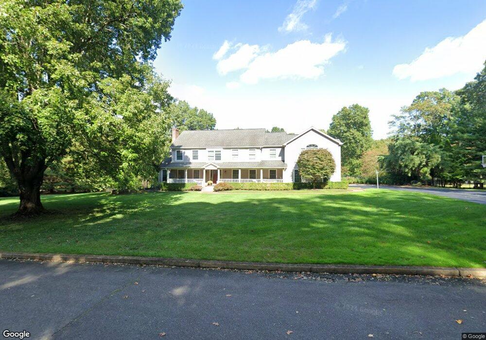
520 Marl Rd Colts Neck, NJ 07722
Estimated Value: $1,466,000 - $1,770,000
4
Beds
3
Baths
4,186
Sq Ft
$393/Sq Ft
Est. Value
About This Home
This home is located at 520 Marl Rd, Colts Neck, NJ 07722 and is currently estimated at $1,645,982, approximately $393 per square foot. 520 Marl Rd is a home located in Monmouth County with nearby schools including Conover Road School, Cedar Drive Middle School, and Colts Neck High School.
Ownership History
Date
Name
Owned For
Owner Type
Purchase Details
Closed on
Dec 13, 2010
Sold by
Haaf David and Haaf Luanne
Bought by
Haaf David and Deluca Luanne
Current Estimated Value
Purchase Details
Closed on
Feb 2, 2001
Sold by
Keane Thomas
Bought by
Haaf David and Haaf Luanne
Home Financials for this Owner
Home Financials are based on the most recent Mortgage that was taken out on this home.
Original Mortgage
$200,000
Outstanding Balance
$71,810
Interest Rate
7%
Estimated Equity
$1,574,172
Create a Home Valuation Report for This Property
The Home Valuation Report is an in-depth analysis detailing your home's value as well as a comparison with similar homes in the area
Home Values in the Area
Average Home Value in this Area
Purchase History
| Date | Buyer | Sale Price | Title Company |
|---|---|---|---|
| Haaf David | -- | None Available | |
| Haaf David | $665,000 | -- |
Source: Public Records
Mortgage History
| Date | Status | Borrower | Loan Amount |
|---|---|---|---|
| Open | Haaf David | $200,000 |
Source: Public Records
Tax History Compared to Growth
Tax History
| Year | Tax Paid | Tax Assessment Tax Assessment Total Assessment is a certain percentage of the fair market value that is determined by local assessors to be the total taxable value of land and additions on the property. | Land | Improvement |
|---|---|---|---|---|
| 2025 | $19,212 | $1,425,900 | $578,100 | $847,800 |
| 2024 | $17,570 | $1,289,400 | $493,100 | $796,300 |
| 2023 | $17,570 | $1,129,200 | $376,500 | $752,700 |
| 2022 | $17,605 | $1,044,000 | $342,800 | $701,200 |
| 2021 | $17,605 | $1,008,300 | $342,800 | $665,500 |
| 2020 | $17,368 | $984,600 | $342,800 | $641,800 |
| 2019 | $17,200 | $976,700 | $342,800 | $633,900 |
| 2018 | $17,194 | $968,700 | $342,800 | $625,900 |
| 2017 | $16,820 | $950,800 | $332,800 | $618,000 |
| 2016 | $16,735 | $966,800 | $352,800 | $614,000 |
| 2015 | $16,673 | $961,000 | $362,800 | $598,200 |
| 2014 | $16,345 | $968,900 | $438,000 | $530,900 |
Source: Public Records
Map
Nearby Homes
- 1 Montana Dr
- 16 Hickory Ln
- 119 Lindy Ln
- 6 Willow Rd
- 17 High Point Rd
- 107 Lawley Dr
- 3 Jockey Terrace N
- 63 Eckert Dr
- 1497 W Front St
- 660 County Route 520
- 1476 W Front St
- 6 Bordens Brook Way
- 201 Dogwood Ln
- 7 Mccampbell Rd
- 17 Woods End Rd
- 784 State Route 34
- 249 County Road 537
- 45 Turnberry Dr
- 509 Newman Springs Rd
- 98 Hockhockson Rd