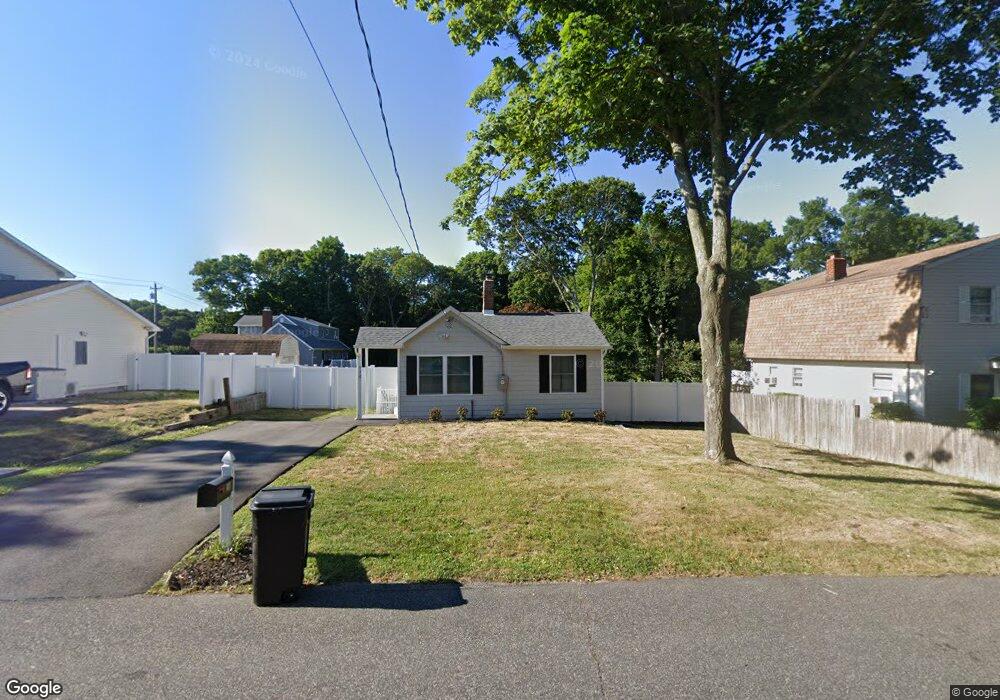
520 Mollie Blvd Holbrook, NY 11741
Estimated Value: $447,000 - $526,000
2
Beds
1
Bath
592
Sq Ft
$813/Sq Ft
Est. Value
About This Home
This home is located at 520 Mollie Blvd, Holbrook, NY 11741 and is currently estimated at $481,486, approximately $813 per square foot. 520 Mollie Blvd is a home located in Suffolk County with nearby schools including Merrimac School, Sachem High School East, and Long Island Baptist Academy.
Ownership History
Date
Name
Owned For
Owner Type
Purchase Details
Closed on
Aug 2, 2022
Sold by
Bkm Prop Of Shoreham Inc
Bought by
Keating Brittany
Current Estimated Value
Home Financials for this Owner
Home Financials are based on the most recent Mortgage that was taken out on this home.
Original Mortgage
$297,600
Interest Rate
6.48%
Mortgage Type
Purchase Money Mortgage
Purchase Details
Closed on
Jan 31, 2022
Sold by
Kirkpatrick Marguerite and Kirkpatrick Gregory
Bought by
Bkm Properties Of Shorehm
Create a Home Valuation Report for This Property
The Home Valuation Report is an in-depth analysis detailing your home's value as well as a comparison with similar homes in the area
Home Values in the Area
Average Home Value in this Area
Purchase History
| Date | Buyer | Sale Price | Title Company |
|---|---|---|---|
| Keating Brittany | $372,000 | None Available | |
| Bkm Properties Of Shorehm | $120,000 | None Available |
Source: Public Records
Mortgage History
| Date | Status | Borrower | Loan Amount |
|---|---|---|---|
| Previous Owner | Keating Brittany | $297,600 | |
| Previous Owner | Keating Brittany | $11,160 |
Source: Public Records
Tax History Compared to Growth
Tax History
| Year | Tax Paid | Tax Assessment Tax Assessment Total Assessment is a certain percentage of the fair market value that is determined by local assessors to be the total taxable value of land and additions on the property. | Land | Improvement |
|---|---|---|---|---|
| 2024 | $3,570 | $22,300 | $8,900 | $13,400 |
| 2023 | $3,570 | $22,300 | $8,900 | $13,400 |
| 2022 | $5,013 | $12,025 | $8,900 | $3,125 |
| 2021 | $5,013 | $12,025 | $8,900 | $3,125 |
| 2020 | $4,455 | $12,025 | $8,900 | $3,125 |
| 2019 | $5,013 | $0 | $0 | $0 |
| 2018 | -- | $12,025 | $8,900 | $3,125 |
| 2017 | $3,370 | $12,025 | $8,900 | $3,125 |
| 2016 | $5,840 | $12,025 | $8,900 | $3,125 |
| 2015 | -- | $12,025 | $8,900 | $3,125 |
| 2014 | -- | $12,025 | $8,900 | $3,125 |
Source: Public Records
Map
Nearby Homes
- 1264 Broadway Ave
- 386 Lillian Blvd
- 1101 Broadway Ave
- 228 Springmeadow Dr Unit H
- 223 Springmeadow Dr Unit E
- 6 Dorothy Ln
- 229 Springmeadow Dr Unit C
- 376 Grace St
- 332 Terry Blvd
- 64 Timber Ridge Dr
- 216 Springmeadow Dr
- 215 Springmeadow Dr Unit F
- 5 Jay Ln
- 423 Alphabet St
- 183 Ballad Cir
- 28 Val Ct
- 19 Timber Ridge Dr
- 70 Parkside St
- 3 Timber Ridge Dr
- 16 Ballad Cir
- 528 Mollie Blvd
- 1244 Broadway Ave
- 512 Mollie Blvd
- 527 Mollie Blvd
- 519 Mollie Blvd
- 511 Mollie Blvd
- 1249 Broadway Ave
- 1253 Broadway Ave
- 490 Mollie Blvd
- 467 Lewis St
- 1245 Broadway Ave
- 501 Mollie Blvd
- 1257 Broadway Ave
- 1257 Broadway Ave
- 1268 Broadway Ave
- 466 Lewis St
- 491 Mollie Blvd
- 1261 Broadway Ave
- 1235 Broadway Ave
- 459 Lewis St