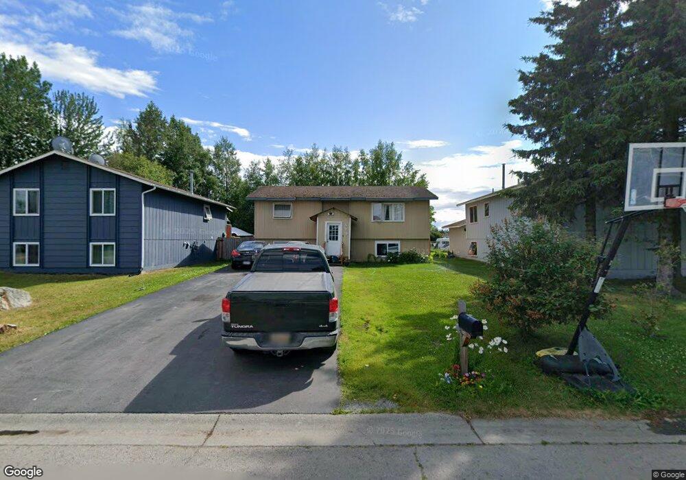
520 W 90th Ave Anchorage, AK 99515
Taku-Campbell NeighborhoodEstimated Value: $169,000 - $465,000
4
Beds
2
Baths
1,854
Sq Ft
$194/Sq Ft
Est. Value
About This Home
This home is located at 520 W 90th Ave, Anchorage, AK 99515 and is currently estimated at $359,090, approximately $193 per square foot. 520 W 90th Ave is a home located in Anchorage Municipality with nearby schools including Campbell Elementary School, Hanshew Middle School, and Service High School.
Ownership History
Date
Name
Owned For
Owner Type
Purchase Details
Closed on
Feb 4, 2002
Sold by
Leary Noel and Leary Marlene V
Bought by
Sengmany Robert and Lakhamsene Bouakham
Current Estimated Value
Home Financials for this Owner
Home Financials are based on the most recent Mortgage that was taken out on this home.
Original Mortgage
$155,800
Outstanding Balance
$64,831
Interest Rate
7.15%
Estimated Equity
$294,259
Purchase Details
Closed on
Aug 19, 1996
Sold by
Young Lorne E and Young Catherine M
Bought by
Morin Patrick J and Morin Sandra D
Home Financials for this Owner
Home Financials are based on the most recent Mortgage that was taken out on this home.
Original Mortgage
$110,072
Interest Rate
8.18%
Mortgage Type
FHA
Purchase Details
Closed on
Sep 28, 1993
Sold by
Crouse Theodore M
Bought by
Leary Marlene V and Visitacion Mariano A
Home Financials for this Owner
Home Financials are based on the most recent Mortgage that was taken out on this home.
Original Mortgage
$98,267
Interest Rate
7.13%
Mortgage Type
FHA
Purchase Details
Closed on
Mar 30, 1989
Sold by
Alaska Housing Finance Corp
Bought by
Crouse Theodore M
Home Financials for this Owner
Home Financials are based on the most recent Mortgage that was taken out on this home.
Original Mortgage
$67,500
Interest Rate
10.76%
Mortgage Type
VA
Create a Home Valuation Report for This Property
The Home Valuation Report is an in-depth analysis detailing your home's value as well as a comparison with similar homes in the area
Home Values in the Area
Average Home Value in this Area
Purchase History
| Date | Buyer | Sale Price | Title Company |
|---|---|---|---|
| Sengmany Robert | -- | First American Title | |
| Morin Patrick J | -- | -- | |
| Morin Patrick J | -- | -- | |
| Leary Marlene V | -- | -- | |
| Leary Marlene V | -- | -- | |
| Crouse Theodore M | -- | -- | |
| Crouse Theodore M | -- | -- |
Source: Public Records
Mortgage History
| Date | Status | Borrower | Loan Amount |
|---|---|---|---|
| Open | Sengmany Robert | $155,800 | |
| Previous Owner | Morin Patrick J | $110,072 | |
| Previous Owner | Leary Marlene V | $98,267 | |
| Previous Owner | Crouse Theodore M | $67,500 |
Source: Public Records
Tax History Compared to Growth
Tax History
| Year | Tax Paid | Tax Assessment Tax Assessment Total Assessment is a certain percentage of the fair market value that is determined by local assessors to be the total taxable value of land and additions on the property. | Land | Improvement |
|---|---|---|---|---|
| 2025 | $4,004 | $350,900 | $107,500 | $243,400 |
| 2024 | $4,004 | $323,000 | $98,500 | $224,500 |
| 2023 | $5,206 | $305,700 | $93,800 | $211,900 |
| 2022 | $4,358 | $308,800 | $93,800 | $215,000 |
| 2021 | $4,952 | $274,800 | $93,800 | $181,000 |
| 2020 | $3,631 | $263,900 | $93,800 | $170,100 |
| 2019 | $3,365 | $255,700 | $93,800 | $161,900 |
| 2018 | $3,242 | $247,100 | $93,800 | $153,300 |
| 2017 | $3,594 | $249,500 | $89,400 | $160,100 |
| 2016 | $3,234 | $257,500 | $84,400 | $173,100 |
| 2015 | $3,234 | $247,500 | $84,400 | $163,100 |
| 2014 | $3,234 | $240,500 | $75,400 | $165,100 |
Source: Public Records
Map
Nearby Homes
- L2 Arctic Blvd
- 374 E 87th Ave
- 1200 W Dimond Blvd Unit 1453
- 8000 Summerset Dr
- L14-18 Laurel Acres
- 7901 Highlander Dr
- 7955 Stanley Dr
- 926 W 80th Ave
- 9162 Aphrodite Dr
- 1028 W 80th Ave
- 7835 Highlander Dr
- 1655 Ira Dr
- 9341 Eris Dr
- 7558 Foxridge Way Unit 6E
- 7530 Foxridge Way Unit 9A
- 7801 Evander Dr
- 1121 W 77th Ave
- 7510 Foxridge Way Unit 2A
- 1124 Contrary Ct
- 810 E 79th Ave