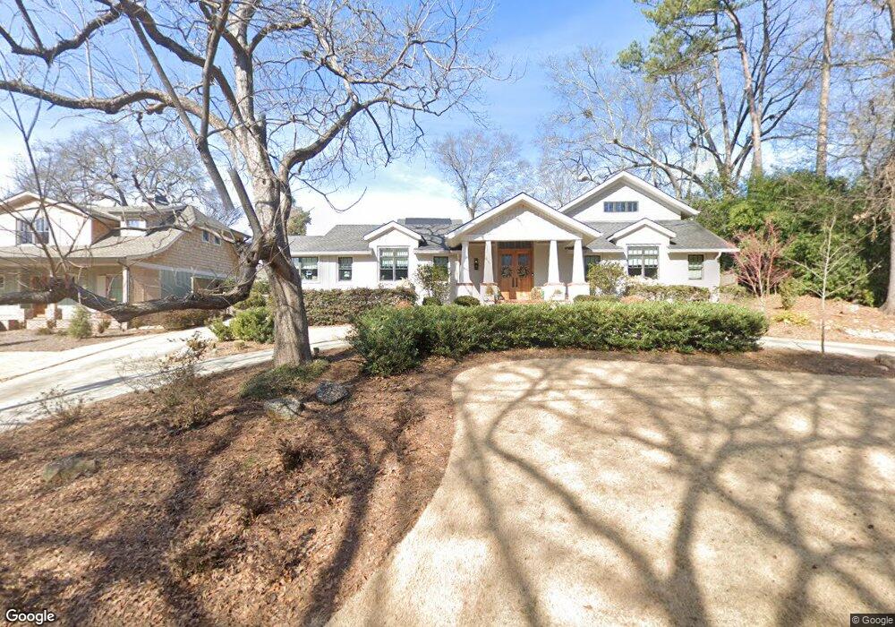
520 W Rutherford St Athens, GA 30606
Five Points NeighborhoodEstimated Value: $1,231,001 - $1,556,000
4
Beds
2
Baths
1,674
Sq Ft
$828/Sq Ft
Est. Value
About This Home
This home is located at 520 W Rutherford St, Athens, GA 30606 and is currently estimated at $1,385,667, approximately $827 per square foot. 520 W Rutherford St is a home located in Clarke County with nearby schools including Barrow Elementary School, Clarke Middle School, and Clarke Central High School.
Ownership History
Date
Name
Owned For
Owner Type
Purchase Details
Closed on
Jan 9, 2014
Sold by
Parker Kenneth B
Bought by
Parker Susan D
Current Estimated Value
Home Financials for this Owner
Home Financials are based on the most recent Mortgage that was taken out on this home.
Original Mortgage
$191,920
Interest Rate
4.44%
Mortgage Type
New Conventional
Purchase Details
Closed on
Nov 15, 1999
Sold by
Stiles Alwyn B
Bought by
A B Stiles Enterprises Lllp
Create a Home Valuation Report for This Property
The Home Valuation Report is an in-depth analysis detailing your home's value as well as a comparison with similar homes in the area
Home Values in the Area
Average Home Value in this Area
Purchase History
| Date | Buyer | Sale Price | Title Company |
|---|---|---|---|
| Parker Susan D | -- | -- | |
| Parker Kenneth B | $239,900 | -- | |
| A B Stiles Enterprises Lllp | -- | -- |
Source: Public Records
Mortgage History
| Date | Status | Borrower | Loan Amount |
|---|---|---|---|
| Closed | Parker Kenneth B | $191,920 |
Source: Public Records
Tax History
| Year | Tax Paid | Tax Assessment Tax Assessment Total Assessment is a certain percentage of the fair market value that is determined by local assessors to be the total taxable value of land and additions on the property. | Land | Improvement |
|---|---|---|---|---|
| 2025 | $16,692 | $706,646 | $115,200 | $591,446 |
| 2024 | $16,692 | $668,244 | $106,560 | $561,684 |
| 2023 | $16,821 | $594,433 | $106,560 | $487,873 |
| 2022 | $14,953 | $478,758 | $100,800 | $377,958 |
| 2021 | $13,724 | $417,248 | $100,800 | $316,448 |
| 2020 | $12,894 | $392,613 | $100,800 | $291,813 |
| 2019 | $12,382 | $374,710 | $100,800 | $273,910 |
| 2018 | $10,586 | $321,797 | $100,800 | $220,997 |
| 2017 | $10,233 | $301,410 | $100,800 | $200,610 |
| 2016 | $9,614 | $283,168 | $100,800 | $182,368 |
| 2015 | $4,681 | $137,674 | $86,400 | $51,274 |
| 2014 | $3,210 | $94,281 | $77,760 | $16,521 |
Source: Public Records
Map
Nearby Homes
- 577 W Cloverhurst Ave
- 230 Woodlawn Ave
- 112 Fortson Dr
- 362 W Cloverhurst Ave
- 265 Springdale St
- 338 Springdale St
- 1055 Baxter St Unit 406
- 1055 Baxter St Unit 201
- 490 Mcwhorter Dr
- 997 S Milledge Ave Unit 3
- 997 S Milledge Ave Unit 2
- 997 S Milledge Ave Unit 1
- 206 Fortson Dr
- 590 Highland Ave
- 224 Fortson Dr
- 1554 S Lumpkin St Unit 4
- 1554 S Lumpkin St Unit 6
- 1554 S Lumpkin St Unit 5
- 1554 S Lumpkin St Unit 1
- 1554 S Lumpkin St Unit 3
- 530 W Rutherford St
- 290 Stanton Way
- 288 Stanton Way
- 296 Stanton Way
- 540 W Rutherford St
- 285 Oakland Way
- 545 W Cloverhurst Ave
- 555 W Cloverhurst Ave
- 515 W Rutherford St
- 535 W Cloverhurst Ave
- 565 W Cloverhurst Ave
- 280 Stanton Way
- 569 W Cloverhurst Ave
- 310 Stanton Way Unit A
- 310 Stanton Way
- 295 Oakland Way
- 230 Oakland Way
- 525 W Cloverhurst Ave
- 312 Stanton Way Unit A
- 312 Stanton Way Unit A
Your Personal Tour Guide
Ask me questions while you tour the home.