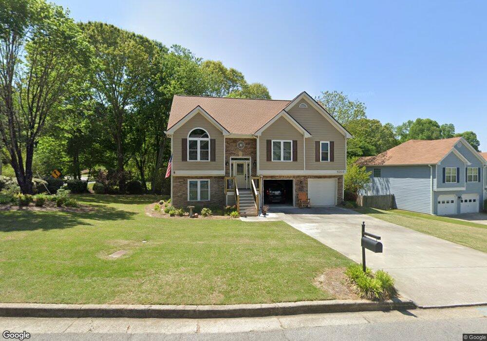
5202 Balin Ln Unit 7 Sugar Hill, GA 30518
Estimated Value: $385,000 - $432,000
4
Beds
3
Baths
1,474
Sq Ft
$276/Sq Ft
Est. Value
About This Home
This home is located at 5202 Balin Ln Unit 7, Sugar Hill, GA 30518 and is currently estimated at $407,084, approximately $276 per square foot. 5202 Balin Ln Unit 7 is a home located in Gwinnett County with nearby schools including Sugar Hill Elementary School, Lanier Middle School, and Lanier High School.
Ownership History
Date
Name
Owned For
Owner Type
Purchase Details
Closed on
Jun 11, 1999
Sold by
Mclin Construction Inc
Bought by
Koehler Richard J and Koehler Nancy A
Current Estimated Value
Home Financials for this Owner
Home Financials are based on the most recent Mortgage that was taken out on this home.
Original Mortgage
$127,850
Outstanding Balance
$32,616
Interest Rate
7.13%
Mortgage Type
VA
Estimated Equity
$374,468
Create a Home Valuation Report for This Property
The Home Valuation Report is an in-depth analysis detailing your home's value as well as a comparison with similar homes in the area
Home Values in the Area
Average Home Value in this Area
Purchase History
| Date | Buyer | Sale Price | Title Company |
|---|---|---|---|
| Koehler Richard J | $139,200 | -- |
Source: Public Records
Mortgage History
| Date | Status | Borrower | Loan Amount |
|---|---|---|---|
| Open | Koehler Richard J | $127,850 |
Source: Public Records
Tax History Compared to Growth
Tax History
| Year | Tax Paid | Tax Assessment Tax Assessment Total Assessment is a certain percentage of the fair market value that is determined by local assessors to be the total taxable value of land and additions on the property. | Land | Improvement |
|---|---|---|---|---|
| 2025 | $555 | $168,240 | $34,000 | $134,240 |
| 2024 | $584 | $154,840 | $32,000 | $122,840 |
| 2023 | $584 | $153,880 | $28,000 | $125,880 |
| 2022 | $584 | $128,920 | $24,000 | $104,920 |
| 2021 | $584 | $101,000 | $18,400 | $82,600 |
| 2020 | $956 | $92,400 | $18,400 | $74,000 |
| 2019 | $867 | $83,880 | $16,000 | $67,880 |
| 2018 | $2,407 | $75,840 | $12,800 | $63,040 |
| 2016 | $2,225 | $68,600 | $12,800 | $55,800 |
| 2015 | $2,068 | $61,840 | $10,000 | $51,840 |
| 2014 | -- | $60,800 | $10,000 | $50,800 |
Source: Public Records
Map
Nearby Homes
- 5166 Thorin Oak Cir Unit 7
- 5229 Pine Branch Ct
- 965 Under Ct
- 5248 Arbor View Ln
- 384 Sunset Hollow St Unit 2
- 384 Sunset Hollow St
- 5152 Park Vale Dr
- 5059 Hidden Branch Dr
- 850 Long Branch Cir
- 870 Long Branch Cir
- 5109 Dogwood Hills Dr
- 5008 Hidden Branch Dr
- 1135 Chastain Dr
- 0 (4989 ?) Hidden Branch Dr
- 5028 Hidden Branch Dr
- 5008/4998 Hidden Branch Dr
- 5000 Sugar Creek Dr
- The Ellison II Plan at Ellison Square
- The Norwood II Plan at Ellison Square
- The Maddux II Plan at Ellison Square
- 5212 Balin Ln
- 862 Whitehead Rd
- 5203 Balin Ln
- 5213 Balin Ln Unit 7
- 1035 Under Ct Unit 6
- 5223 Balin Ln
- 1025 Under Ct Unit 6
- 5126 Thorin Oak Cir
- 868 Whitehead Rd
- 883 Whitehead Rd
- 1065 Under Ct
- 5136 Thorin Oak Cir
- 5136 Thorin Oak Cir Unit OAK
- 4960 Arbor View Way
- 1058 Under Ct
- 1048 Under Ct
- 1038 Under Ct Unit 6
- 1015 Under Ct Unit 6
- 4970 Arbor View Way Unit 3