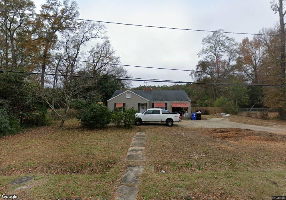
5203 Boyd Dr Columbus, GA 31909
North Columbus NeighborhoodEstimated Value: $169,000 - $197,000
3
Beds
2
Baths
1,567
Sq Ft
$117/Sq Ft
Est. Value
About This Home
This home is located at 5203 Boyd Dr, Columbus, GA 31909 and is currently estimated at $183,333, approximately $116 per square foot. 5203 Boyd Dr is a home located in Muscogee County with nearby schools including Gentian Elementary School, Midland Middle School, and Hardaway High School.
Ownership History
Date
Name
Owned For
Owner Type
Purchase Details
Closed on
Nov 18, 2025
Sold by
Windham David A
Bought by
Windham David A and Windham Jane
Current Estimated Value
Home Financials for this Owner
Home Financials are based on the most recent Mortgage that was taken out on this home.
Original Mortgage
$200,000
Outstanding Balance
$196,304
Interest Rate
6.34%
Mortgage Type
Credit Line Revolving
Estimated Equity
-$12,971
Purchase Details
Closed on
Nov 29, 2021
Sold by
Windham William M
Bought by
Windham David A
Purchase Details
Closed on
Nov 22, 2021
Sold by
Windham Marvin R
Bought by
Windham David A
Purchase Details
Closed on
Jul 22, 2013
Sold by
Sec Of Housing & U
Bought by
Windham Marvin R
Purchase Details
Closed on
Mar 14, 2013
Sold by
Everbank
Bought by
Sec Of Housing & Urban
Purchase Details
Closed on
Mar 5, 2013
Sold by
Colley Candance B
Bought by
Everbank
Create a Home Valuation Report for This Property
The Home Valuation Report is an in-depth analysis detailing your home's value as well as a comparison with similar homes in the area
Home Values in the Area
Average Home Value in this Area
Purchase History
| Date | Buyer | Sale Price | Title Company |
|---|---|---|---|
| Windham David A | -- | None Listed On Document | |
| Windham David A | -- | None Listed On Document | |
| Windham David A | -- | -- | |
| Windham David A | -- | None Listed On Document | |
| Windham Marvin R | $28,200 | -- | |
| Sec Of Housing & Urban | $57,246 | -- | |
| Everbank | $57,246 | -- |
Source: Public Records
Mortgage History
| Date | Status | Borrower | Loan Amount |
|---|---|---|---|
| Open | Windham David A | $200,000 |
Source: Public Records
Tax History
| Year | Tax Paid | Tax Assessment Tax Assessment Total Assessment is a certain percentage of the fair market value that is determined by local assessors to be the total taxable value of land and additions on the property. | Land | Improvement |
|---|---|---|---|---|
| 2025 | $1,899 | $61,684 | $11,276 | $50,408 |
| 2024 | -- | $61,684 | $11,276 | $50,408 |
| 2023 | $2,430 | $61,684 | $11,276 | $50,408 |
| 2022 | $2,178 | $53,344 | $11,276 | $42,068 |
| 2021 | $16 | $53,156 | $11,276 | $41,880 |
| 2020 | $16 | $53,156 | $11,276 | $41,880 |
| 2019 | $18 | $53,156 | $11,276 | $41,880 |
| 2018 | $18 | $53,156 | $11,276 | $41,880 |
| 2017 | $20 | $53,156 | $11,276 | $41,880 |
| 2016 | $21 | $31,151 | $3,622 | $27,529 |
| 2015 | $9 | $31,151 | $3,622 | $27,529 |
| 2014 | $22 | $13,780 | $3,622 | $10,158 |
| 2013 | $1,060 | $25,595 | $3,622 | $21,973 |
Source: Public Records
Map
Nearby Homes
- 3514 Vernon Dr
- 3504 Vernon Dr
- 3630 Vernon Dr
- 5408 Moon Rd
- 5502 Southlea Ln
- 4151 Anglin Rd
- 4230 Carlene Dr
- 4102 Norwood Dr
- 3790 Graham Way
- 3935 Tifton Dr
- 5224 Miller Rd
- 4133 Pickering Dr
- 4004 Tifton Dr
- 5820 Windsor Dr
- 4630 Fairview Dr
- 3091 Mustang Dr
- 5836 Sherborne Dr
- 3716 University Ave
- 4032 Pickering Dr
- 3342 Windermere St
Your Personal Tour Guide
Ask me questions while you tour the home.