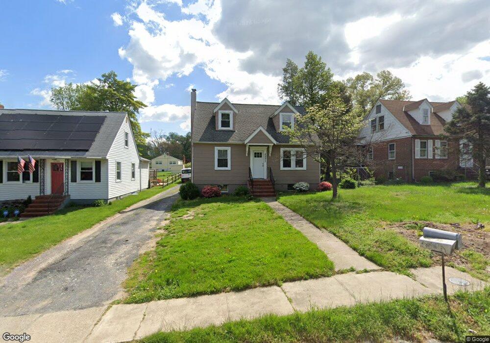
5207 Benson Ave Halethorpe, MD 21227
Estimated Value: $350,000 - $399,232
4
Beds
3
Baths
1,800
Sq Ft
$206/Sq Ft
Est. Value
About This Home
This home is located at 5207 Benson Ave, Halethorpe, MD 21227 and is currently estimated at $370,808, approximately $206 per square foot. 5207 Benson Ave is a home located in Baltimore County with nearby schools including Halethorpe Elementary School, Arbutus Middle School, and Lansdowne High School.
Ownership History
Date
Name
Owned For
Owner Type
Purchase Details
Closed on
Aug 14, 2020
Sold by
Reese Properties Llc
Bought by
Orbell Brent
Current Estimated Value
Home Financials for this Owner
Home Financials are based on the most recent Mortgage that was taken out on this home.
Original Mortgage
$200,000
Outstanding Balance
$177,414
Interest Rate
3%
Mortgage Type
New Conventional
Estimated Equity
$193,394
Purchase Details
Closed on
Jan 18, 2018
Sold by
Hollis Mark A and Hollis Austin D
Bought by
Reese Properties Llc
Create a Home Valuation Report for This Property
The Home Valuation Report is an in-depth analysis detailing your home's value as well as a comparison with similar homes in the area
Home Values in the Area
Average Home Value in this Area
Purchase History
| Date | Buyer | Sale Price | Title Company |
|---|---|---|---|
| Orbell Brent | $250,000 | Homeland Title & Escrow Ltd | |
| Reese Properties Llc | $116,000 | None Available |
Source: Public Records
Mortgage History
| Date | Status | Borrower | Loan Amount |
|---|---|---|---|
| Open | Orbell Brent | $200,000 |
Source: Public Records
Tax History
| Year | Tax Paid | Tax Assessment Tax Assessment Total Assessment is a certain percentage of the fair market value that is determined by local assessors to be the total taxable value of land and additions on the property. | Land | Improvement |
|---|---|---|---|---|
| 2025 | $3,690 | $277,000 | -- | -- |
| 2024 | $3,690 | $244,800 | $55,500 | $189,300 |
| 2023 | $1,803 | $241,767 | $0 | $0 |
| 2022 | $3,549 | $238,733 | $0 | $0 |
| 2021 | $2,895 | $235,700 | $55,500 | $180,200 |
| 2020 | $3,183 | $209,600 | $0 | $0 |
| 2019 | $2,224 | $183,500 | $0 | $0 |
| 2018 | $1,908 | $157,400 | $55,500 | $101,900 |
| 2017 | $2,156 | $153,000 | $0 | $0 |
| 2016 | $971 | $148,600 | $0 | $0 |
| 2015 | $971 | $144,200 | $0 | $0 |
| 2014 | $971 | $144,200 | $0 | $0 |
Source: Public Records
Map
Nearby Homes
- 0 Dewitt Rd
- 1328 Stevens Ave
- 1416 Sulphur Spring Rd
- 1258 Linden Ave
- 1212 Seven Oaks Rd
- 5521 Willys Ave
- 1211 Poplar Ave
- 5522 Ashbourne Rd
- 1204 Birch Ave
- 5605 Oregon Ave
- 5402 Council St
- 4401 Ridge Dr
- 951 Elm Ridge Ave
- 4412 Maple Ave
- 3930 Benson Ave
- 1207 Brewster St
- 4415 Linden Ave
- 1009 Circle Dr
- 902 Elm Ridge Ave
- 4606 Ridge Ave
- 5208 Larlin Rd
- 5211 Benson Ave
- 5206 Larlin Rd
- 5203 Benson Ave
- 5212 Larlin Rd
- 5204 Larlin Rd
- 5208 Benson Ave
- 5206 Benson Ave
- 5205 Benson Ave
- 5214 Larlin Rd
- 5204 Benson Ave
- 5210 Benson Ave
- 5202 Benson Ave
- 5212 Benson Ave
- 5217 Benson Ave
- 5200 Larlin Rd
- 5209 Benson Ave
- 5203 Arbutus Ave
- 5214 Benson Ave
- 5218 Larlin Rd
Your Personal Tour Guide
Ask me questions while you tour the home.