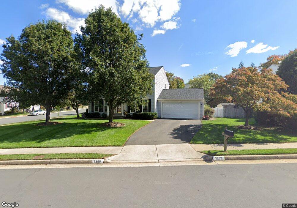
5209 Belle Plains Dr Centreville, VA 20120
Estimated Value: $829,026 - $879,000
4
Beds
4
Baths
2,178
Sq Ft
$394/Sq Ft
Est. Value
About This Home
This home is located at 5209 Belle Plains Dr, Centreville, VA 20120 and is currently estimated at $859,007, approximately $394 per square foot. 5209 Belle Plains Dr is a home located in Fairfax County with nearby schools including Cub Run Elementary, Ormond Stone Middle School, and Westfield High School.
Ownership History
Date
Name
Owned For
Owner Type
Purchase Details
Closed on
Dec 21, 2011
Sold by
Belle Pond Llc
Bought by
Sosnowski Robert G
Current Estimated Value
Home Financials for this Owner
Home Financials are based on the most recent Mortgage that was taken out on this home.
Original Mortgage
$474,997
Outstanding Balance
$324,774
Interest Rate
4%
Mortgage Type
VA
Estimated Equity
$534,233
Purchase Details
Closed on
May 31, 2011
Sold by
Karcher Chris A
Bought by
Belle Pond Llc
Create a Home Valuation Report for This Property
The Home Valuation Report is an in-depth analysis detailing your home's value as well as a comparison with similar homes in the area
Home Values in the Area
Average Home Value in this Area
Purchase History
| Date | Buyer | Sale Price | Title Company |
|---|---|---|---|
| Sosnowski Robert G | $465,000 | -- | |
| Belle Pond Llc | $510,000 | -- |
Source: Public Records
Mortgage History
| Date | Status | Borrower | Loan Amount |
|---|---|---|---|
| Open | Sosnowski Robert G | $474,997 |
Source: Public Records
Tax History Compared to Growth
Tax History
| Year | Tax Paid | Tax Assessment Tax Assessment Total Assessment is a certain percentage of the fair market value that is determined by local assessors to be the total taxable value of land and additions on the property. | Land | Improvement |
|---|---|---|---|---|
| 2025 | $8,217 | $774,640 | $305,000 | $469,640 |
| 2024 | $8,217 | $709,240 | $290,000 | $419,240 |
| 2023 | $8,004 | $709,240 | $290,000 | $419,240 |
| 2022 | $7,792 | $681,420 | $275,000 | $406,420 |
| 2021 | $6,863 | $584,790 | $230,000 | $354,790 |
| 2020 | $6,487 | $548,150 | $230,000 | $318,150 |
| 2019 | $6,206 | $524,390 | $220,000 | $304,390 |
| 2018 | $5,862 | $509,770 | $215,000 | $294,770 |
| 2017 | $5,788 | $498,530 | $210,000 | $288,530 |
| 2016 | $5,775 | $498,530 | $210,000 | $288,530 |
| 2015 | $5,564 | $498,530 | $210,000 | $288,530 |
| 2014 | $5,327 | $478,440 | $200,000 | $278,440 |
Source: Public Records
Map
Nearby Homes
- 5417 Gladewright Dr
- 5127 Woodfield Dr
- 14415 Glencrest Cir Unit 112
- 5155 Woodfield Dr
- 5100 Castle Harbor Way Unit 117
- 5515 Buggy Whip Dr
- 5515 Belle Pond Dr
- 14437 Glencrest Cir Unit 129
- 14286 Patriarch Ct
- 5570 Village Center Dr
- 14700 Cranoke St
- 4915 Longmire Way Unit 124
- 14303 Yesler Ave
- 4902 Longmire Way Unit 24
- 14600 Stone Range Dr
- 14722 Braddock Rd
- 14542 Eddy Ct
- 14801 Carlbern Dr
- 14714 Cranoke St
- 5705 Croatan Ct
- 14373 Round Lick Ln
- 5211 Belle Plains Dr
- 14371 Round Lick Ln
- 5208 Belle Plains Dr
- 5207 Belle Plains Dr
- 5210 Belle Plains Dr
- 14369 Round Lick Ln
- 14374 Round Lick Ln
- 5213 Belle Plains Dr
- 5206 Belle Plains Dr
- 14363 Round Lick Ln
- 14379 Round Lick Ln
- 14365 Round Lick Ln
- 5212 Belle Plains Dr
- 5205 Belle Plains Dr
- 14367 Round Lick Ln
- 14352 Locust Grove Ct
- 14364 Round Lick Ln
- 14380 Round Lick Ln
- 14372 Round Lick Ln