Estimated Value: $265,000 - $280,659
3
Beds
2
Baths
1,112
Sq Ft
$246/Sq Ft
Est. Value
About This Home
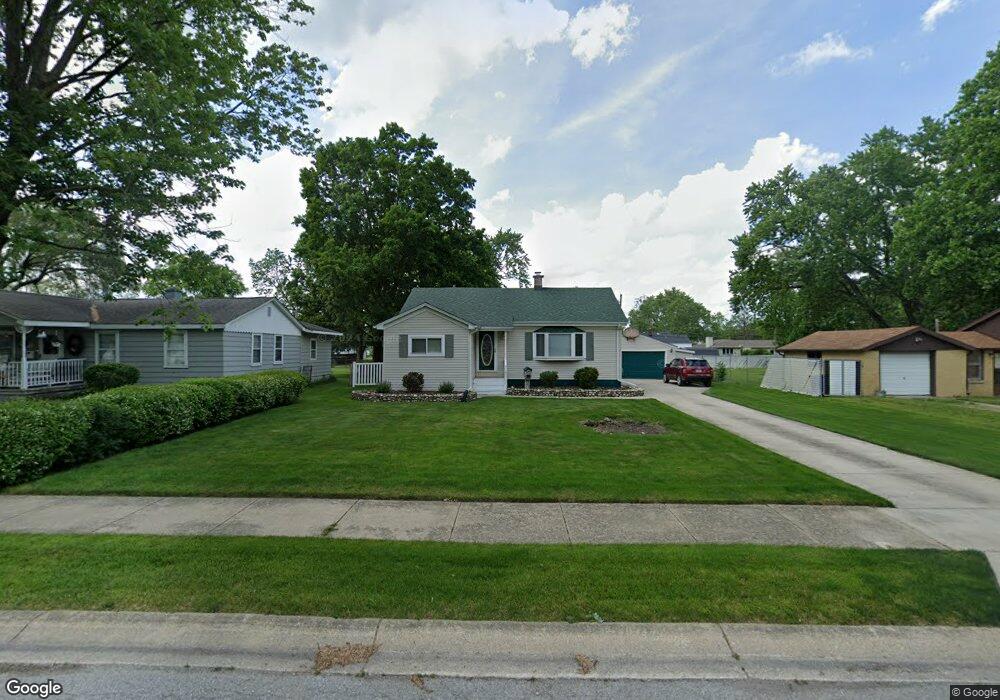
This home is located at 521 213th Place, Dyer, IN 46311 and is currently estimated at $273,415, approximately $245 per square foot. 521 213th Place is a home located in Lake County with nearby schools including Protsman Elementary School, Kahler Middle School, and Lake Central High School.
Ownership History
Date
Name
Owned For
Owner Type
Purchase Details
Closed on
Dec 11, 2008
Sold by
Brown Ruth L
Bought by
Brown Aaron L
Current Estimated Value
Purchase Details
Closed on
May 23, 2005
Sold by
Hollis Shawn D
Bought by
Brown Aaron L and Brown Ruth L
Home Financials for this Owner
Home Financials are based on the most recent Mortgage that was taken out on this home.
Original Mortgage
$118,500
Outstanding Balance
$62,697
Interest Rate
6.07%
Mortgage Type
Fannie Mae Freddie Mac
Estimated Equity
$210,718
Create a Home Valuation Report for This Property
The Home Valuation Report is an in-depth analysis detailing your home's value as well as a comparison with similar homes in the area
Home Values in the Area
Average Home Value in this Area
Purchase History
| Date | Buyer | Sale Price | Title Company |
|---|---|---|---|
| Brown Aaron L | -- | None Available | |
| Brown Aaron L | -- | Chicago Title Insurance Comp |
Source: Public Records
Mortgage History
| Date | Status | Borrower | Loan Amount |
|---|---|---|---|
| Open | Brown Aaron L | $118,500 |
Source: Public Records
Tax History Compared to Growth
Tax History
| Year | Tax Paid | Tax Assessment Tax Assessment Total Assessment is a certain percentage of the fair market value that is determined by local assessors to be the total taxable value of land and additions on the property. | Land | Improvement |
|---|---|---|---|---|
| 2024 | $6,050 | $239,300 | $77,500 | $161,800 |
| 2023 | $2,504 | $237,900 | $77,500 | $160,400 |
| 2022 | $2,504 | $218,300 | $77,500 | $140,800 |
| 2021 | $2,201 | $201,600 | $77,500 | $124,100 |
| 2020 | $2,243 | $199,800 | $62,800 | $137,000 |
| 2019 | $1,852 | $167,700 | $27,900 | $139,800 |
| 2018 | $1,662 | $159,300 | $27,300 | $132,000 |
| 2017 | $1,457 | $152,700 | $27,300 | $125,400 |
| 2016 | $1,468 | $152,000 | $27,300 | $124,700 |
| 2014 | $1,312 | $147,700 | $27,300 | $120,400 |
| 2013 | $1,389 | $145,000 | $27,200 | $117,800 |
Source: Public Records
Map
Nearby Homes
- 1416 Sheffield Ave
- 1437 Madison Ave
- 1514 Harrison Ave
- 601 Berkley Dr
- 1341 Capri Ln
- 708 212th St
- 511 Devon Dr
- 723 211th St
- 917 Perthshire Ln
- T-1415 Adler Plan at Parkside
- T-1647 Wren Plan at Parkside
- 1008 Cambridge Ct
- 370 Linda Ln
- 408 Swan Dr Unit 2-D
- 1012 Richmond Ct
- 458 Alanna Ln Unit 458
- 477 Linda Ln Unit 477
- 483 Linda Ln Unit 483
- 431 Alanna Ln
- 810 Swan Dr Unit 2A