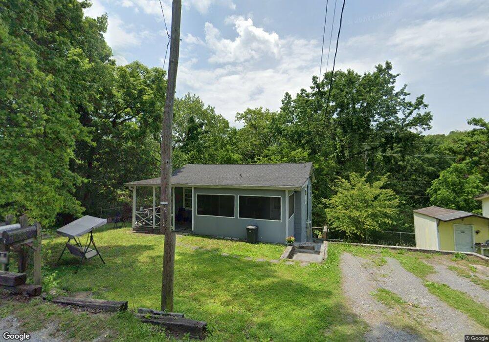
521 Baker St Rossville, GA 30741
Estimated Value: $92,000 - $186,000
--
Bed
2
Baths
806
Sq Ft
$173/Sq Ft
Est. Value
About This Home
This home is located at 521 Baker St, Rossville, GA 30741 and is currently estimated at $139,111, approximately $172 per square foot. 521 Baker St is a home located in Walker County with nearby schools including Rossville Elementary School, Rossville Middle School, and Ridgeland High School.
Ownership History
Date
Name
Owned For
Owner Type
Purchase Details
Closed on
Mar 7, 2011
Sold by
Henderson Dorothy Rae
Bought by
Mook Bobbie
Current Estimated Value
Purchase Details
Closed on
Feb 7, 1995
Sold by
Mcdowell Thomas H
Bought by
Henderson Dorothy Rae
Purchase Details
Closed on
Dec 5, 1990
Sold by
Charron Russell H and Wf Joyce
Bought by
Mcdowell Thomas H
Purchase Details
Closed on
Jun 9, 1990
Sold by
Logan Tommy Ray
Bought by
Charron Russell H and Wf Joyce
Purchase Details
Closed on
Nov 18, 1978
Sold by
Harmon Lloyd P
Bought by
Logan Tommy Ray
Purchase Details
Closed on
Jan 1, 1972
Bought by
Harmon Lloyd P
Create a Home Valuation Report for This Property
The Home Valuation Report is an in-depth analysis detailing your home's value as well as a comparison with similar homes in the area
Home Values in the Area
Average Home Value in this Area
Purchase History
| Date | Buyer | Sale Price | Title Company |
|---|---|---|---|
| Mook Bobbie | -- | -- | |
| Henderson Dorothy Rae | $34,000 | -- | |
| Mcdowell Thomas H | $14,100 | -- | |
| Charron Russell H | -- | -- | |
| Logan Tommy Ray | -- | -- | |
| Harmon Lloyd P | -- | -- |
Source: Public Records
Tax History Compared to Growth
Tax History
| Year | Tax Paid | Tax Assessment Tax Assessment Total Assessment is a certain percentage of the fair market value that is determined by local assessors to be the total taxable value of land and additions on the property. | Land | Improvement |
|---|---|---|---|---|
| 2024 | $1,179 | $51,904 | $1,828 | $50,076 |
| 2023 | $1,145 | $49,252 | $1,828 | $47,424 |
| 2022 | $1,062 | $41,858 | $1,828 | $40,030 |
| 2021 | $817 | $28,254 | $1,828 | $26,426 |
| 2020 | $753 | $24,846 | $1,828 | $23,018 |
| 2019 | $789 | $25,662 | $1,828 | $23,834 |
| 2018 | $679 | $25,662 | $1,828 | $23,834 |
| 2017 | $859 | $25,662 | $1,828 | $23,834 |
| 2016 | $698 | $20,360 | $1,864 | $18,496 |
| 2015 | $697 | $19,100 | $1,880 | $17,220 |
| 2014 | $582 | $19,100 | $1,880 | $17,220 |
| 2013 | -- | $19,099 | $1,880 | $17,219 |
Source: Public Records
Map
Nearby Homes
- 515 Hogan Rd
- 408 Hollywood Dr
- 164 S Mission Ridge Dr
- 317 Signal Dr
- 74 Kriswood Dr
- 624 Corbley Rd
- 610 Corbley Rd
- 136 Summit St
- Lot 81 Battle Bluff Dr
- 405 Miami Ave
- 42 Battle Bluff Dr
- 47 Battle Bluff Dr
- 189 Leinbach Rd
- 1 Fox Chase St
- 0 Park City Rd Unit 1519998
- 4 Carroll Ln
- 118 Alpine Dr
- 0 Summit St Unit 1514634
- 3 Fox Chase St
- 811 Park City Rd
- 519 Baker St
- 523 Baker St
- 520 Baker St
- 519 Baker St
- 420 Longview Dr
- 522 Baker St
- 1306 Park City Rd
- 418 Longview Dr
- 416 Longview Dr
- 410 Mohawk Trail
- 435 Longview Dr
- 417 Longview Dr
- 412 Longview Dr
- 415 Longview Dr
- 518 Hogan Rd
- 324 Hogan Rd
- LOT 5 Hogan Rd Unit LOT 5
- LOT 4 Hogan Rd Unit LOT 4
- 428 Evans Rd
- 432 Hogan Cir