Estimated Value: $275,000 - $374,000
--
Bed
--
Bath
--
Sq Ft
3.5
Acres
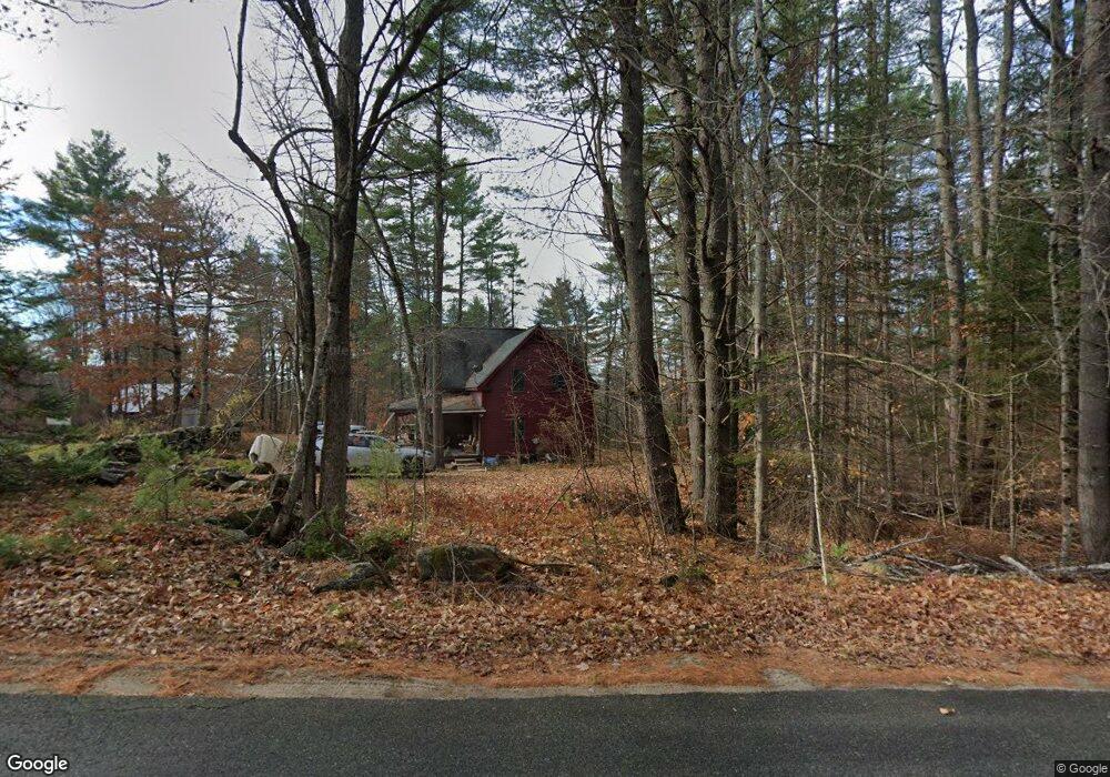
About This Home
This home is located at 521 Durgintown Rd, Hiram, ME 04041 and is currently estimated at $338,769. 521 Durgintown Rd is a home.
Ownership History
Date
Name
Owned For
Owner Type
Purchase Details
Closed on
Apr 14, 2022
Sold by
Johnson William L and Johnson Marilyn P
Bought by
Johnson William L
Current Estimated Value
Purchase Details
Closed on
May 10, 2019
Sold by
Ruth A Paul Ret and Paul
Bought by
Anderson Brent A
Home Financials for this Owner
Home Financials are based on the most recent Mortgage that was taken out on this home.
Original Mortgage
$90,500
Interest Rate
4%
Mortgage Type
New Conventional
Create a Home Valuation Report for This Property
The Home Valuation Report is an in-depth analysis detailing your home's value as well as a comparison with similar homes in the area
Home Values in the Area
Average Home Value in this Area
Purchase History
| Date | Buyer | Sale Price | Title Company |
|---|---|---|---|
| Johnson William L | -- | None Available | |
| Johnson William L | -- | None Available | |
| Johnson William L | -- | None Available | |
| Anderson Brent A | -- | -- | |
| Anderson Brent A | -- | -- |
Source: Public Records
Mortgage History
| Date | Status | Borrower | Loan Amount |
|---|---|---|---|
| Previous Owner | Anderson Brent A | $90,500 |
Source: Public Records
Tax History Compared to Growth
Tax History
| Year | Tax Paid | Tax Assessment Tax Assessment Total Assessment is a certain percentage of the fair market value that is determined by local assessors to be the total taxable value of land and additions on the property. | Land | Improvement |
|---|---|---|---|---|
| 2024 | $3,455 | $317,580 | $59,860 | $257,720 |
| 2023 | $3,379 | $273,400 | $47,890 | $225,510 |
| 2022 | $3,095 | $210,250 | $39,910 | $170,340 |
| 2021 | $3,072 | $210,250 | $39,910 | $170,340 |
| 2020 | $3,057 | $210,250 | $39,910 | $170,340 |
| 2019 | $3,024 | $207,970 | $37,630 | $170,340 |
| 2018 | $3,030 | $207,970 | $37,630 | $170,340 |
| 2017 | $2,963 | $207,330 | $37,630 | $169,700 |
| 2016 | $3,384 | $230,390 | $37,630 | $192,760 |
Source: Public Records
Map
Nearby Homes
- 96 Maple St
- 696 S Hiram Rd
- 20 Main St
- 4 Bridge St
- 6-13 Main St
- 992 Pequawket Trail
- Lot #3 Jordan Heights Rd
- Lot #2 Jordan Heights Rd
- Lot #8 Jordan Heights Rd
- Lot #4 Jordan Heights Rd
- Lot #11 Jordan Heights Rd
- 266 S Hiram Rd
- 11 Marston Rd
- 30 Waterfront Dr
- 174 Marston Rd
- 35 Pine St
- 272 Tripptown Rd
- 32 Summer St
- 8 Graffam Rd
- 12 Main St
- 531 Durgintown Rd
- 497 Durgintown Rd
- 554 Durgintown Rd
- 567 Durgintown Rd
- 563 Durgintown Rd
- 579 Durgintown Rd
- 27 Plains Rd
- 447 Durgintown Rd
- 3-26 Plains Rd
- 5 Plains Rd
- 18 Plains Rd
- 615 Durgintown Rd
- 616 Durgintown Rd
- 552 Durgintown Rd
- 29 Rock Crop Dr
- 35 Rock Crop Dr
- 632 Durgintown Rd
- 635 Durgintown Rd
- 638 Durgintown Rd
- 651 Durgintown Rd