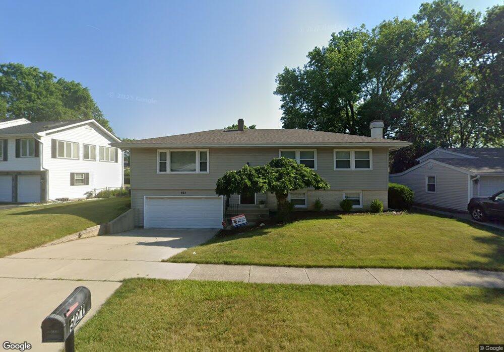
521 Forestway Dr Buffalo Grove, IL 60089
South Buffalo Grove NeighborhoodEstimated Value: $410,000 - $474,000
3
Beds
2
Baths
1,400
Sq Ft
$312/Sq Ft
Est. Value
About This Home
This home is located at 521 Forestway Dr, Buffalo Grove, IL 60089 and is currently estimated at $437,231, approximately $312 per square foot. 521 Forestway Dr is a home located in Cook County with nearby schools including Henry W Longfellow Elementary School, Cooper Middle School, and Buffalo Grove High School.
Ownership History
Date
Name
Owned For
Owner Type
Purchase Details
Closed on
Aug 24, 2006
Sold by
Hayter Scott C and Hayter Lori M
Bought by
Miller Brian and Miller Kimberly
Current Estimated Value
Home Financials for this Owner
Home Financials are based on the most recent Mortgage that was taken out on this home.
Original Mortgage
$322,500
Outstanding Balance
$193,729
Interest Rate
6.77%
Mortgage Type
Unknown
Estimated Equity
$243,502
Create a Home Valuation Report for This Property
The Home Valuation Report is an in-depth analysis detailing your home's value as well as a comparison with similar homes in the area
Home Values in the Area
Average Home Value in this Area
Purchase History
| Date | Buyer | Sale Price | Title Company |
|---|---|---|---|
| Miller Brian | $367,500 | Cti |
Source: Public Records
Mortgage History
| Date | Status | Borrower | Loan Amount |
|---|---|---|---|
| Open | Miller Brian | $322,500 |
Source: Public Records
Tax History Compared to Growth
Tax History
| Year | Tax Paid | Tax Assessment Tax Assessment Total Assessment is a certain percentage of the fair market value that is determined by local assessors to be the total taxable value of land and additions on the property. | Land | Improvement |
|---|---|---|---|---|
| 2024 | $8,540 | $30,000 | $6,965 | $23,035 |
| 2023 | $8,184 | $30,000 | $6,965 | $23,035 |
| 2022 | $8,184 | $30,000 | $6,965 | $23,035 |
| 2021 | $8,355 | $26,978 | $4,449 | $22,529 |
| 2020 | $8,209 | $26,978 | $4,449 | $22,529 |
| 2019 | $8,199 | $29,910 | $4,449 | $25,461 |
| 2018 | $8,232 | $27,340 | $3,869 | $23,471 |
| 2017 | $8,101 | $27,340 | $3,869 | $23,471 |
| 2016 | $7,802 | $27,340 | $3,869 | $23,471 |
| 2015 | $6,948 | $23,075 | $3,289 | $19,786 |
| 2014 | $6,851 | $23,075 | $3,289 | $19,786 |
| 2013 | $6,315 | $23,075 | $3,289 | $19,786 |
Source: Public Records
Map
Nearby Homes
- 408 Indian Hill Dr
- 921 Bernard Dr
- 859 Beechwood Rd
- 1130 Bernard Dr
- 329 Timber Hill Rd
- 535 Estate Dr
- 720 Weidner Rd Unit 302
- 410 Chatham Cir
- 813 Stradford Cir Unit 21B2
- 780 Weidner Rd Unit 300
- 705 Grove Dr Unit 101
- 820 Weidner Rd Unit 409
- 476 W Happfield Dr Unit 10AL
- 671 Hapsfield Ln Unit 105
- 98 Stonegate Rd
- 751 W Happfield Dr Unit 30
- 715 W Whiting Ln
- 715 W Happfield Dr
- 455 Mayfair Ln
- 812 W Whiting Ln
- 515 Forestway Dr
- 527 Forestway Dr
- 494 Longwood Dr
- 488 Longwood Dr
- 533 Forestway Dr
- 498 Longwood Dr
- 509 Forestway Dr
- 530 Forestway Dr
- 538 Forestway Dr
- 526 Forestway Dr
- 480 Longwood Dr
- 502 Longwood Dr
- 6 Forestway Ct
- 497 Forestway Dr
- 520 Forestway Dr
- 512 Forestway Dr
- 506 Longwood Dr
- 1 Katherine Ct
- 485 Longwood Dr
- 2 Katherine Ct