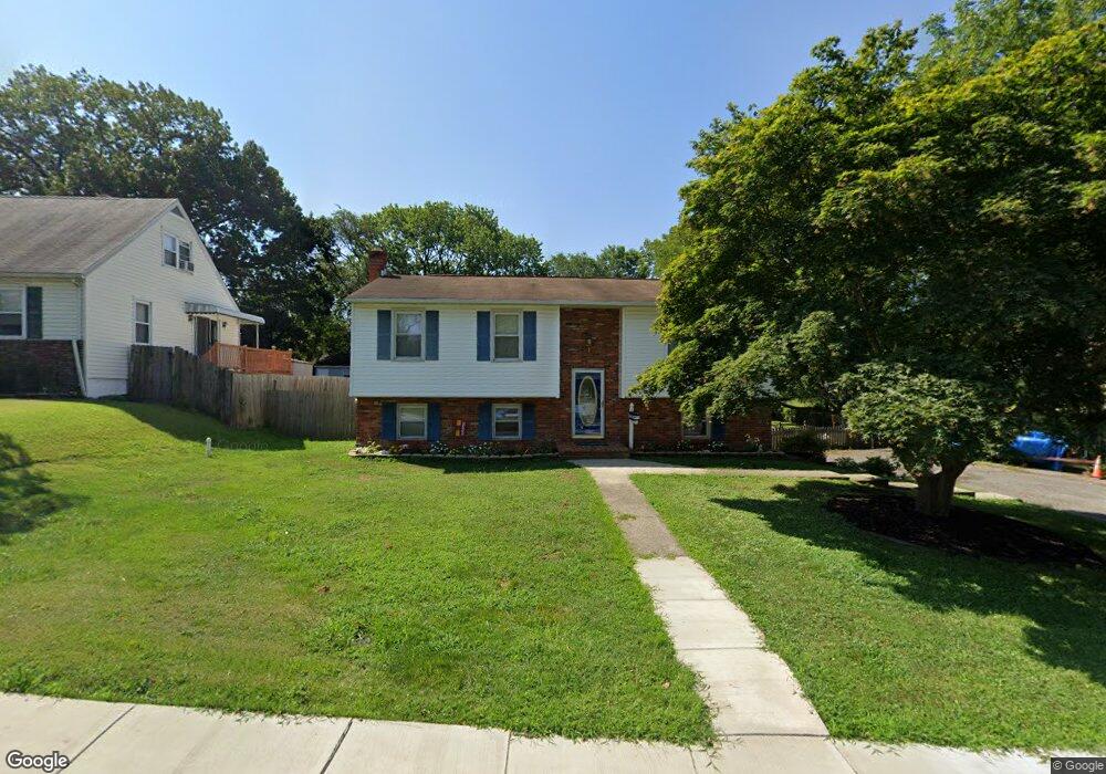
521 Hawthorne Rd Linthicum Heights, MD 21090
Estimated Value: $484,571 - $586,000
--
Bed
2
Baths
1,989
Sq Ft
$271/Sq Ft
Est. Value
About This Home
This home is located at 521 Hawthorne Rd, Linthicum Heights, MD 21090 and is currently estimated at $538,143, approximately $270 per square foot. 521 Hawthorne Rd is a home located in Anne Arundel County with nearby schools including Lindale Middle School, North County High School, and St. Philip Neri Elementary School.
Ownership History
Date
Name
Owned For
Owner Type
Purchase Details
Closed on
Jun 13, 2000
Sold by
Scott Frank J
Bought by
Sumwalt Sterling J and Sumwalt Nancy D
Current Estimated Value
Purchase Details
Closed on
Jul 11, 1996
Sold by
Smith Mark E
Bought by
Scott Frank J and Scott Mary T
Purchase Details
Closed on
Jun 30, 1987
Sold by
Duerr Jeffrey P
Bought by
Smith Mark E
Home Financials for this Owner
Home Financials are based on the most recent Mortgage that was taken out on this home.
Original Mortgage
$101,650
Interest Rate
10.35%
Create a Home Valuation Report for This Property
The Home Valuation Report is an in-depth analysis detailing your home's value as well as a comparison with similar homes in the area
Home Values in the Area
Average Home Value in this Area
Purchase History
| Date | Buyer | Sale Price | Title Company |
|---|---|---|---|
| Sumwalt Sterling J | $173,000 | -- | |
| Scott Frank J | $167,000 | -- | |
| Smith Mark E | $107,000 | -- |
Source: Public Records
Mortgage History
| Date | Status | Borrower | Loan Amount |
|---|---|---|---|
| Previous Owner | Smith Mark E | $101,650 | |
| Closed | Sumwalt Sterling J | -- |
Source: Public Records
Tax History Compared to Growth
Tax History
| Year | Tax Paid | Tax Assessment Tax Assessment Total Assessment is a certain percentage of the fair market value that is determined by local assessors to be the total taxable value of land and additions on the property. | Land | Improvement |
|---|---|---|---|---|
| 2025 | $3,334 | $456,600 | $201,500 | $255,100 |
| 2024 | $3,334 | $435,067 | $0 | $0 |
| 2023 | $3,228 | $413,533 | $0 | $0 |
| 2022 | $3,008 | $392,000 | $181,500 | $210,500 |
| 2021 | $5,903 | $379,333 | $0 | $0 |
| 2020 | $2,856 | $366,667 | $0 | $0 |
| 2019 | $2,803 | $354,000 | $159,500 | $194,500 |
| 2018 | $3,517 | $346,867 | $0 | $0 |
| 2017 | $2,646 | $339,733 | $0 | $0 |
| 2016 | -- | $332,600 | $0 | $0 |
| 2015 | -- | $332,600 | $0 | $0 |
| 2014 | -- | $332,600 | $0 | $0 |
Source: Public Records
Map
Nearby Homes
- 504 Cleveland Rd
- 443 W Maple Rd
- 536 Forest View Rd
- 697 W Maple Rd
- 6222 Woodland Rd
- 437 Kingwood Rd
- 401 Forest View Rd
- 306 S Camp Meade Rd
- 304 S Camp Meade Rd
- 6300 Buck Cavey Ln
- 300 Twin Oaks Rd
- 107 Michael Ave
- 112 S Camp Meade Rd
- 835 White Ave
- 102 Catalpa Rd
- 306 John Ave
- 319 School Ln
- 0 Laurel Rd
- 331 E Maple Rd
- 133 Glendale Ave
- 519 Hawthorne Rd
- 517 Hawthorne Rd
- 525 Hawthorne Rd
- 526 Cleveland Rd
- 524 Cleveland Rd
- 515 Hawthorne Rd
- 528 Cleveland Rd
- 522 Cleveland Rd
- 518 Hawthorne Rd
- 530 Cleveland Rd
- 516 Hawthorne Rd
- 520 Cleveland Rd
- 532 Cleveland Rd
- 520 Hawthorne Rd
- 513 Hawthorne Rd
- 522 Hawthorne Rd
- 0 Cleveland Rd
- 514 Hawthorne Rd
- 534 Cleveland Rd
- 516 Cleveland Rd