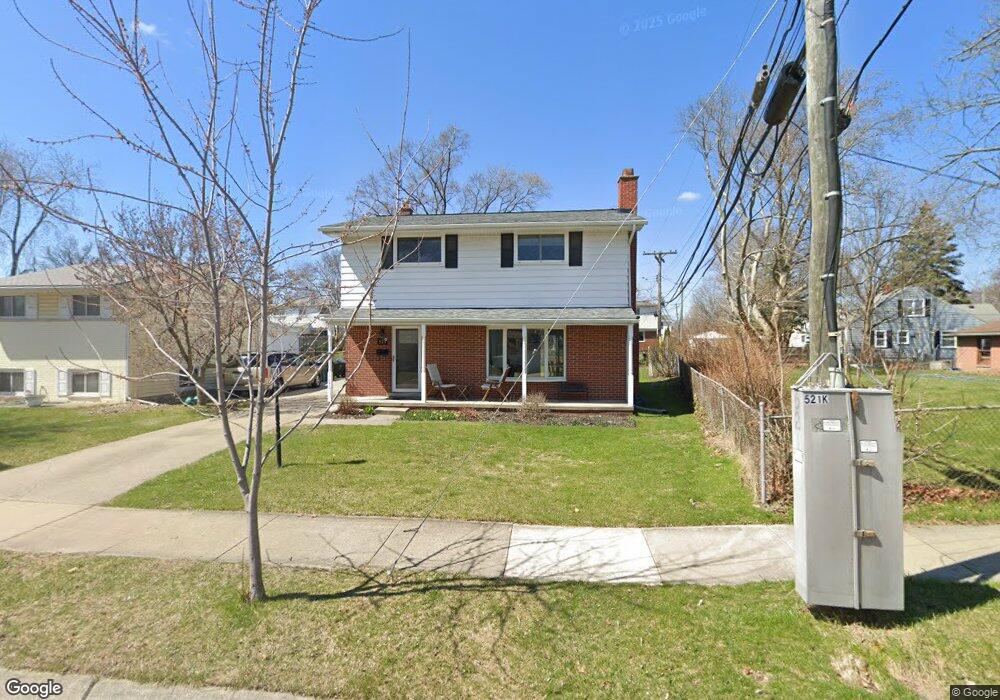
521 Kinross Ave Clawson, MI 48017
Estimated Value: $353,000 - $426,000
4
Beds
2
Baths
1,500
Sq Ft
$248/Sq Ft
Est. Value
About This Home
This home is located at 521 Kinross Ave, Clawson, MI 48017 and is currently estimated at $372,320, approximately $248 per square foot. 521 Kinross Ave is a home located in Oakland County with nearby schools including Clawson High School, Japhet School, and Guardian Angels School.
Ownership History
Date
Name
Owned For
Owner Type
Purchase Details
Closed on
Mar 24, 2008
Sold by
Villasana Isabel
Bought by
Schneider Kevin D and Schneider Angela S
Current Estimated Value
Purchase Details
Closed on
May 13, 2005
Sold by
Seipke Dennis D and Seipke Isabelle C
Bought by
Villasana Isabel
Home Financials for this Owner
Home Financials are based on the most recent Mortgage that was taken out on this home.
Original Mortgage
$172,000
Interest Rate
5.75%
Mortgage Type
New Conventional
Create a Home Valuation Report for This Property
The Home Valuation Report is an in-depth analysis detailing your home's value as well as a comparison with similar homes in the area
Home Values in the Area
Average Home Value in this Area
Purchase History
| Date | Buyer | Sale Price | Title Company |
|---|---|---|---|
| Schneider Kevin D | $190,000 | Title One Inc | |
| Villasana Isabel | $215,000 | Parks Title |
Source: Public Records
Mortgage History
| Date | Status | Borrower | Loan Amount |
|---|---|---|---|
| Previous Owner | Villasana Isabel | $172,000 |
Source: Public Records
Tax History Compared to Growth
Tax History
| Year | Tax Paid | Tax Assessment Tax Assessment Total Assessment is a certain percentage of the fair market value that is determined by local assessors to be the total taxable value of land and additions on the property. | Land | Improvement |
|---|---|---|---|---|
| 2024 | $3,549 | $145,150 | $0 | $0 |
| 2023 | $3,403 | $132,490 | $0 | $0 |
| 2022 | $3,430 | $122,850 | $0 | $0 |
| 2021 | $3,360 | $115,880 | $0 | $0 |
| 2020 | $3,255 | $109,410 | $0 | $0 |
| 2019 | $3,364 | $105,230 | $0 | $0 |
| 2018 | $3,340 | $98,050 | $0 | $0 |
| 2017 | $3,320 | $95,100 | $0 | $0 |
| 2016 | $3,360 | $89,470 | $0 | $0 |
| 2015 | -- | $82,000 | $0 | $0 |
| 2014 | -- | $71,100 | $0 | $0 |
| 2011 | -- | $64,770 | $0 | $0 |
Source: Public Records
Map
Nearby Homes
- 846 Phillips Ave
- 609 John M Ave
- 908 W Elmwood Ave
- Fairfax Plan at The Village at Clawson Park
- Penrose Plan at The Village at Clawson Park
- 351 W Baker Ave
- 290 Broadacre Ave
- 496 Langley Blvd
- 321 N Washington Ave
- 1092 Shenandoah Dr
- 232 S Manitou Ave
- 4921 N Crooks Rd Unit N-10
- 4909 Crooks Rd Unit C7
- 4909 Crooks Rd Unit 4
- 1823 Torquay Ave
- 4921 Crooks Rd Unit M-10
- 1226 Shenandoah Dr
- 4952 Coventry St Unit 315
- 4909 Coventry St Unit 287
- 1806 Torquay Ave
- 511 Kinross Ave
- 719 Phillips Ave
- 501 Kinross Ave
- 518 N Marias Ave
- 528 N Marias Ave
- 504 N Marias Ave
- 439 Kinross Ave
- 697 Phillips Ave
- 739 Phillips Ave
- 520 Kinross Ave
- 442 N Marias Ave
- 450 Kinross Ave
- 431 Kinross Ave
- 440 Kinross Ave
- 685 Phillips Ave
- 432 N Marias Ave
- 423 Kinross Ave
- 675 Phillips Ave
- 432 Kinross Ave
- 519 N Bywood Ave