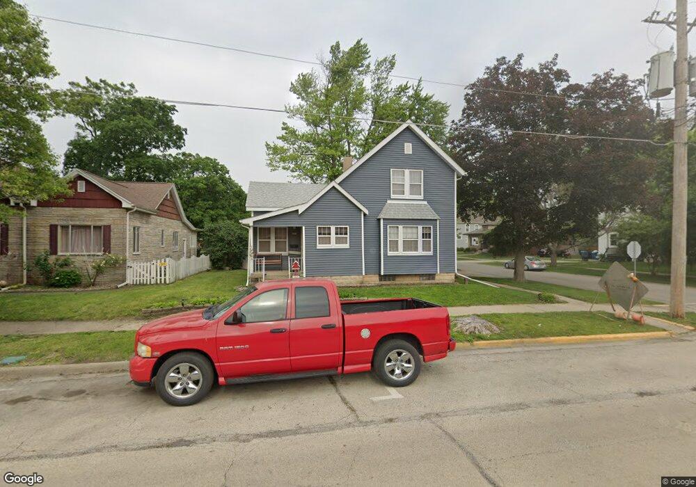
521 N Mill St Pontiac, IL 61764
Estimated Value: $123,316 - $133,000
3
Beds
1
Bath
1,378
Sq Ft
$92/Sq Ft
Est. Value
About This Home
This home is located at 521 N Mill St, Pontiac, IL 61764 and is currently estimated at $127,329, approximately $92 per square foot. 521 N Mill St is a home located in Livingston County with nearby schools including Central Elementary School, Washington Elementary School, and Lincoln Elementary School.
Ownership History
Date
Name
Owned For
Owner Type
Purchase Details
Closed on
Sep 1, 2010
Sold by
Smith Briana
Bought by
Waber Terry and Waber Brenda
Current Estimated Value
Home Financials for this Owner
Home Financials are based on the most recent Mortgage that was taken out on this home.
Original Mortgage
$95,220
Outstanding Balance
$63,036
Interest Rate
4.49%
Estimated Equity
$64,293
Purchase Details
Closed on
May 27, 2009
Sold by
Tissiere Todd J and Tissiere Rita J
Bought by
Smith Briana
Home Financials for this Owner
Home Financials are based on the most recent Mortgage that was taken out on this home.
Original Mortgage
$84,343
Interest Rate
4.83%
Create a Home Valuation Report for This Property
The Home Valuation Report is an in-depth analysis detailing your home's value as well as a comparison with similar homes in the area
Home Values in the Area
Average Home Value in this Area
Purchase History
| Date | Buyer | Sale Price | Title Company |
|---|---|---|---|
| Waber Terry | $91,500 | -- | |
| Smith Briana | $86,000 | -- |
Source: Public Records
Mortgage History
| Date | Status | Borrower | Loan Amount |
|---|---|---|---|
| Open | Waber Terry | $95,220 | |
| Previous Owner | Smith Briana | $84,343 |
Source: Public Records
Tax History Compared to Growth
Tax History
| Year | Tax Paid | Tax Assessment Tax Assessment Total Assessment is a certain percentage of the fair market value that is determined by local assessors to be the total taxable value of land and additions on the property. | Land | Improvement |
|---|---|---|---|---|
| 2024 | $2,467 | $32,679 | $3,864 | $28,815 |
| 2023 | $2,366 | $30,570 | $3,615 | $26,955 |
| 2022 | $2,777 | $33,618 | $3,615 | $30,003 |
| 2021 | $2,678 | $32,325 | $3,476 | $28,849 |
| 2020 | $2,635 | $31,353 | $3,371 | $27,982 |
| 2019 | $2,548 | $29,980 | $3,223 | $26,757 |
| 2018 | $2,617 | $30,809 | $3,256 | $27,553 |
| 2017 | $2,607 | $30,778 | $3,253 | $27,525 |
| 2016 | $2,626 | $31,152 | $3,293 | $27,859 |
| 2015 | $2,653 | $31,152 | $3,293 | $27,859 |
| 2013 | $2,005 | $25,994 | $3,529 | $22,465 |
Source: Public Records
Map
Nearby Homes
- 205 E Howard St
- 765 N Main St
- 503 W Livingston St
- 219 E Howard St
- 819 N Chicago St
- 409 W Water St
- Lot 3 W Cleary St
- Lot 14 W Sherman Ave
- 225 E Pierce St
- 511 E Prairie St
- 618 W Sherman Ave
- 804 N Walnut St
- 510 E Washington St
- 606 N Ladd St
- 101 E Grove St
- 304 S Mill St
- 615 W South St
- 734 W Henry St
- 907 E Madison St
- 413 E Timber St
- 517 N Mill St
- 212 W Prairie St
- 201 W Prairie St
- 220 W Prairie St
- 215 W Prairie St
- 607 N Mill St
- 219 W Prairie St
- 619 N Mill St
- 625 N Mill St
- 521 N Plum St
- 420 N Plum St
- 307 W Prairie St
- 302 W North St
- 703 N Mill St
- 319 W Prairie St
- 308 W North St
- 413 N Main St
- 419 N Plum St
- 119 W North St
- 520 N Main St