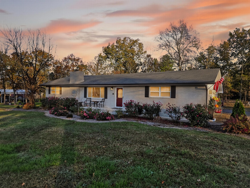
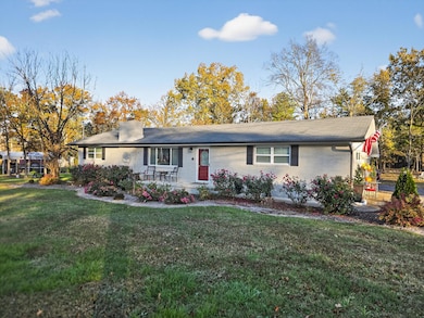
521 Steele Rd Rossville, GA 30741
Westside NeighborhoodEstimated payment $2,887/month
Highlights
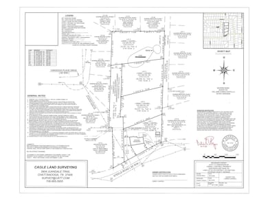
- 3.08 Acre Lot
- No HOA
- Eat-In Kitchen
- Wood Flooring
- Porch
- Brick Exterior Construction
About This Home
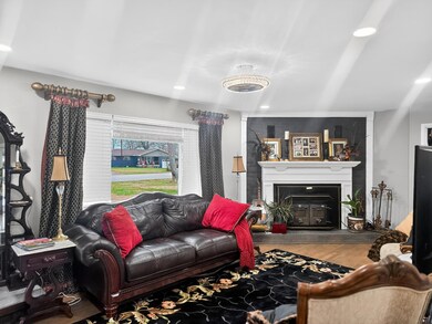
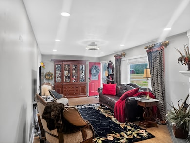
Welcome to 521 Steele Road, Rossville, GA—a rare opportunity to own a versatile, income-producing property sitting proudly atop 3.08 beautifully surveyed acres just minutes from East Ridge. This 4-bedroom, 3-bath home offers the perfect blend of privacy, flexibility, and location. One of the standout features is the converted garage now operating as a separate Airbnb unit, creating an incredible opportunity for instant rental income, multigenerational living, or your own private guest suite. Whether you're an investor, house-hacker, or simply want space to spread out, this setup delivers options. Perched in an elevated setting, the property offers a peaceful feel while still being just outside the conveniences of Chattanooga and East Ridge—giving you the best of both worlds: quiet country living with quick access to shopping, dining, and major routes. With surveyed acreage, room to expand, and built-in income potential, 521 Steele Road is more than just a home—it's a lifestyle and a strategy all in one.
Home Details
Home Type
- Single Family
Est. Annual Taxes
- $1,590
Year Built
- Built in 1964
Lot Details
- 3.08 Acre Lot
- Level Lot
Parking
- Off-Street Parking
Home Design
- Brick Exterior Construction
- Brick Foundation
- Stone Foundation
- Shingle Roof
Interior Spaces
- 1,963 Sq Ft Home
- Living Room with Fireplace
- Basement
- Crawl Space
- Washer and Dryer
- Property Views
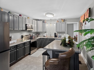
Kitchen
- Eat-In Kitchen
- Built-In Oven
- Electric Range
- Dishwasher
Flooring
- Wood
- Carpet
Bedrooms and Bathrooms
- 4 Bedrooms
- 3 Full Bathrooms
- Bathtub with Shower
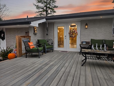
Outdoor Features
- Porch
Schools
- West Side Elementary School
- Lakeview Middle School
- Lakeview-Ft. Oglethorpe High School
Utilities
- Central Air
- Heat Pump System
- Electric Water Heater
- Cable TV Available
Community Details
- No Home Owners Association
- Brookvale Ests Subdivision
Listing and Financial Details
- Assessor Parcel Number 0001l031
Map
Home Values in the Area
Average Home Value in this Area
Tax History
| Year | Tax Paid | Tax Assessment Tax Assessment Total Assessment is a certain percentage of the fair market value that is determined by local assessors to be the total taxable value of land and additions on the property. | Land | Improvement |
|---|---|---|---|---|
| 2024 | $1,712 | $82,256 | $14,760 | $67,496 |
| 2023 | $975 | $65,696 | $14,760 | $50,936 |
| 2022 | $1,111 | $51,620 | $14,760 | $36,860 |
| 2021 | $1,038 | $51,620 | $14,760 | $36,860 |
| 2020 | $1,077 | $46,547 | $15,180 | $31,367 |
| 2019 | $1,042 | $46,547 | $15,180 | $31,367 |
| 2018 | $1,150 | $46,547 | $15,180 | $31,367 |
| 2017 | $1,095 | $46,326 | $15,180 | $31,146 |
| 2016 | $1,082 | $43,649 | $15,180 | $28,469 |
| 2015 | -- | $43,649 | $15,180 | $28,469 |
| 2014 | -- | $40,992 | $12,522 | $28,469 |
| 2013 | -- | $40,991 | $12,522 | $28,469 |
Property History
| Date | Event | Price | List to Sale | Price per Sq Ft |
|---|---|---|---|---|
| 12/09/2025 12/09/25 | For Sale | $525,000 | 0.0% | $267 / Sq Ft |
| 12/09/2025 12/09/25 | Price Changed | $525,000 | -- | $267 / Sq Ft |
Purchase History
| Date | Type | Sale Price | Title Company |
|---|---|---|---|
| Quit Claim Deed | -- | -- | |
| Warranty Deed | $62,650 | -- | |
| Warranty Deed | $7,000 | -- | |
| Deed | -- | -- | |
| Deed | -- | -- | |
| Deed | -- | -- |
Source: Greater Chattanooga REALTORS®
MLS Number: 1523807
APN: 0001L-031
Disclaimer: Certain information contained herein is derived from information provided by parties other than Homes.com. All information provided is deemed reliable, but is not guaranteed to be accurate and should be independently verified.
![]() IDX information is provided exclusively for consumers’ personal, noncommercial use, that it may not be used for any purpose other than to identify prospective properties consumers may be interested in purchasing.
IDX information is provided exclusively for consumers’ personal, noncommercial use, that it may not be used for any purpose other than to identify prospective properties consumers may be interested in purchasing.
Data is deemed reliable but is not guaranteed accurate by the MLS.
Ten-X does not display the entire MLS of Chattanooga, Inc. database on this website. The listings of some real estate brokerage firms have been excluded. Some or all of the listings displayed may not belong to the firm whose website is being visited
Copyright© 2025 by Chattanooga Association of REALTORS®
- 599 Steele Rd
- 210 Honeyberry Ln
- 69 Anchor Dr
- 344 Flagstone Dr
- 767 Steele Rd
- 420 Flagstone Dr
- 239 Flagstone Dr
- 196 Flagstone Dr
- 64 Yellow Brick Rd
- 396 Idle Place Cir
- 378 Idle Place Cir
- 390 Idle Place Cir
- 81 Idle Place Cir
- 66 Yellow Brick Rd
- 631 N Peppercorn Ln
- 164 Idle Place Cir
- 146 Idle Place Cir
- 372 Idle Place Cir
- 57 Idle Place Cir
- 211 Idle Place Cir
- 141 Idle Place Cir
- 26 W Horizon Dr
- 950 Park Lake Rd
- 1663 Keeble St
- 5348 Rose St
- 1516 Springvale Rd Unit 1
- 1516 Springvale Rd Unit 2
- 35 Savannah Way Unit 41Ashton
- 1252 Cloud Springs Ln
- 5322 Clemons Rd
- 276 S Center St
- 50 General Davis Rd
- 913 State Line Rd
- 1604 McBrien Rd
- 100 Brookhaven Cir
- 1408C Mana Ln
- 2212 S Cedar Ln
- 705 State Line Rd
- 6619 State Line Rd
- 15 Greenway Dr
