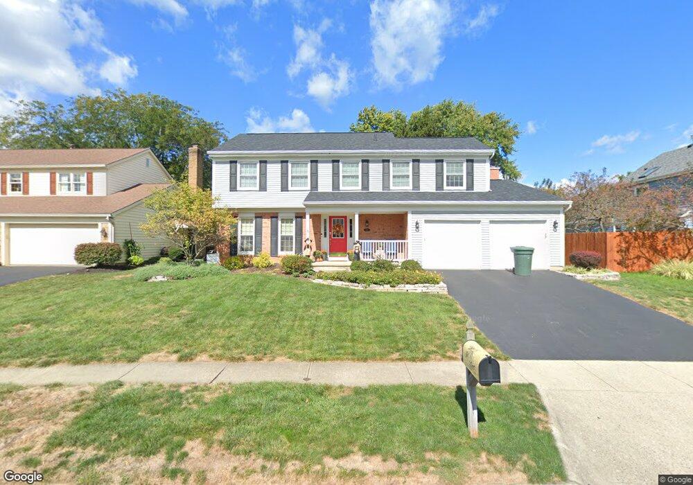
5211 Darry Ln Dublin, OH 43016
Shannon Heights NeighborhoodEstimated Value: $461,000 - $517,000
4
Beds
3
Baths
2,196
Sq Ft
$220/Sq Ft
Est. Value
About This Home
This home is located at 5211 Darry Ln, Dublin, OH 43016 and is currently estimated at $483,247, approximately $220 per square foot. 5211 Darry Ln is a home located in Franklin County with nearby schools including Thomas Elementary School, John Sells Middle School, and Dublin Coffman High School.
Ownership History
Date
Name
Owned For
Owner Type
Purchase Details
Closed on
Nov 18, 2005
Sold by
Strong Jeffrey A
Bought by
Kent Kelly D
Current Estimated Value
Purchase Details
Closed on
Aug 15, 2002
Sold by
Kanner Dale S
Bought by
Strong Jeffrey A and Kent Kelly D
Home Financials for this Owner
Home Financials are based on the most recent Mortgage that was taken out on this home.
Original Mortgage
$165,700
Interest Rate
6.56%
Mortgage Type
Purchase Money Mortgage
Purchase Details
Closed on
May 13, 2002
Sold by
Kanner Sonia M
Bought by
Kanner Dale S
Home Financials for this Owner
Home Financials are based on the most recent Mortgage that was taken out on this home.
Original Mortgage
$150,400
Interest Rate
7%
Purchase Details
Closed on
Jun 26, 1992
Bought by
Kanner Dale S and Kanner Sonia M
Purchase Details
Closed on
May 1, 1985
Purchase Details
Closed on
Dec 1, 1984
Create a Home Valuation Report for This Property
The Home Valuation Report is an in-depth analysis detailing your home's value as well as a comparison with similar homes in the area
Home Values in the Area
Average Home Value in this Area
Purchase History
| Date | Buyer | Sale Price | Title Company |
|---|---|---|---|
| Kent Kelly D | -- | -- | |
| Strong Jeffrey A | $195,000 | Title First Agency Inc | |
| Kanner Dale S | -- | Discovery Title Agency Inc | |
| Kanner Dale S | $143,500 | -- | |
| -- | $108,600 | -- | |
| -- | -- | -- |
Source: Public Records
Mortgage History
| Date | Status | Borrower | Loan Amount |
|---|---|---|---|
| Previous Owner | Strong Jeffrey A | $165,700 | |
| Previous Owner | Kanner Dale S | $150,400 |
Source: Public Records
Tax History
| Year | Tax Paid | Tax Assessment Tax Assessment Total Assessment is a certain percentage of the fair market value that is determined by local assessors to be the total taxable value of land and additions on the property. | Land | Improvement |
|---|---|---|---|---|
| 2025 | $8,705 | $143,930 | $45,680 | $98,250 |
| 2024 | $8,705 | $143,930 | $45,680 | $98,250 |
| 2023 | $8,583 | $143,920 | $45,675 | $98,245 |
| 2022 | $7,389 | $115,160 | $31,540 | $83,620 |
| 2021 | $7,509 | $115,160 | $31,540 | $83,620 |
| 2020 | $7,464 | $115,160 | $31,540 | $83,620 |
| 2019 | $7,109 | $97,100 | $26,290 | $70,810 |
| 2018 | $6,475 | $97,100 | $26,290 | $70,810 |
| 2017 | $6,563 | $97,100 | $26,290 | $70,810 |
| 2016 | $5,778 | $80,300 | $17,890 | $62,410 |
| 2015 | $5,814 | $80,300 | $17,890 | $62,410 |
| 2014 | $5,820 | $80,300 | $17,890 | $62,410 |
| 2013 | $2,814 | $76,475 | $17,045 | $59,430 |
Source: Public Records
Map
Nearby Homes
- 5884 Parkbridge Ln Unit 193
- 5885 Ballymead Blvd
- 5875 Parkbridge Ln
- 5701 Shannon Heights Blvd
- 5850 Chatterfield Dr
- 5500 Saddlebrook Dr
- 5735 Newbank Cir Unit 303
- 5506 Shannon Heights Blvd
- 5790 Newgate Rd Unit 5790
- 6171 Water Bank St
- 3917 Man o War Ct
- 6187 Water Bank St
- 5622 Riverside Dr
- 4070 Hanover Square Dr Unit 4070
- 3263 Scioto Ridge Rd
- 3166 Kingstree Ct
- 3913 Shadowstone Way
- 3122 Tromley Ct
- 4222 Bradhurst Dr Unit 15
- 6074 Hildenboro Dr
- 3739 Monahan Ln
- 3751 Monahan Ln
- 5195 Darry Ln
- 5208 Darry Ln
- 3763 Monahan Ln
- 3721 Monahan Ln
- 5196 Darry Ln
- 5187 Darry Ln
- 3722 Monahan Ln
- 5184 Darry Ln
- 5179 Darry Ln
- 3777 Monahan Ln
- 3714 Monahan Ln
- 5868 Connolly Ct
- 3713 Monahan Ln
- 5876 Connolly Ct
- 5173 Banbridge Ln
- 5244 Whitegate Ct
- 5860 Connolly Ct
- 3746 Monahan Ln
Your Personal Tour Guide
Ask me questions while you tour the home.