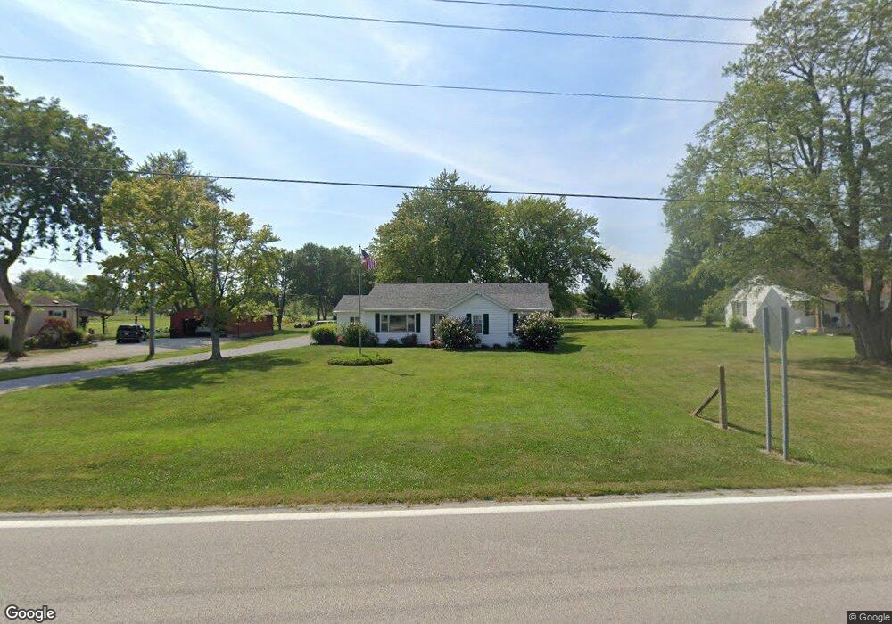
5213 State Route 320 New Paris, OH 45347
Estimated Value: $176,000 - $198,000
3
Beds
2
Baths
1,416
Sq Ft
$135/Sq Ft
Est. Value
About This Home
This home is located at 5213 State Route 320, New Paris, OH 45347 and is currently estimated at $190,861, approximately $134 per square foot. 5213 State Route 320 is a home located in Preble County with nearby schools including National Trail Elementary School, National Trail Middle School, and National Trail High School.
Ownership History
Date
Name
Owned For
Owner Type
Purchase Details
Closed on
May 28, 2004
Sold by
Burnett Rhonda S
Bought by
Burnett David B
Current Estimated Value
Home Financials for this Owner
Home Financials are based on the most recent Mortgage that was taken out on this home.
Original Mortgage
$80,000
Interest Rate
7.5%
Mortgage Type
New Conventional
Create a Home Valuation Report for This Property
The Home Valuation Report is an in-depth analysis detailing your home's value as well as a comparison with similar homes in the area
Home Values in the Area
Average Home Value in this Area
Purchase History
| Date | Buyer | Sale Price | Title Company |
|---|---|---|---|
| Burnett David B | -- | None Available |
Source: Public Records
Mortgage History
| Date | Status | Borrower | Loan Amount |
|---|---|---|---|
| Closed | Burnett David B | $80,000 |
Source: Public Records
Tax History Compared to Growth
Tax History
| Year | Tax Paid | Tax Assessment Tax Assessment Total Assessment is a certain percentage of the fair market value that is determined by local assessors to be the total taxable value of land and additions on the property. | Land | Improvement |
|---|---|---|---|---|
| 2024 | $1,174 | $42,670 | $9,280 | $33,390 |
| 2023 | $1,174 | $42,670 | $9,280 | $33,390 |
| 2022 | $1,214 | $31,850 | $7,070 | $24,780 |
| 2021 | $1,304 | $31,850 | $7,070 | $24,780 |
| 2020 | $1,237 | $31,850 | $7,070 | $24,780 |
| 2019 | $1,130 | $30,110 | $6,970 | $23,140 |
| 2018 | $1,190 | $30,110 | $6,970 | $23,140 |
| 2017 | $1,225 | $30,110 | $6,970 | $23,140 |
| 2016 | $1,091 | $30,350 | $6,760 | $23,590 |
| 2014 | $1,814 | $30,350 | $6,760 | $23,590 |
| 2013 | $1,814 | $30,345 | $6,755 | $23,590 |
Source: Public Records
Map
Nearby Homes
- 10263 Cr 335
- 10051 State Route 320
- 4741 Wolverton Rd
- 6100 Hodgin Rd Unit LotWP002
- 6100 Hodgin Rd
- 0 Industrial Pkwy Unit 10048533
- 0 Industrial Pkwy Unit 202406115
- 443 S Spring St
- 700 W Cherry St
- 6670 Murray Rd
- 0 Hodgin Rd Unit LotWP003 23959386
- 0 Hodgin Rd
- 202 Nelson St
- 200 Pearl St
- 307 E Cherry St
- 5.71A Greenmount Pike
- 123 Hutton St
- 125 High St
- 8458 Hawley Mills Rd
- 61000 Hodgin Rd
- 5239 State Route 320
- 5191 State Route 320
- 5177 State Route 320
- 5257 State Route 320
- 5232 State Route 320
- 5200 State Route 320
- 5277 State Route 320
- 5295 State Route 320
- 5174 State Route 320
- 5182 State Route 320
- 5135 State Route 320
- 5142 State Route 320
- 0 Robin Ln
- 5315 State Route 320
- 5107 State Route 320
- 5300 Kimberly Ct
- 5315 St Rt 320
- 5262 Kimberly Ct
- 0 Robin Dr Unit 10022693
- 0 Robin Dr Unit 10024600