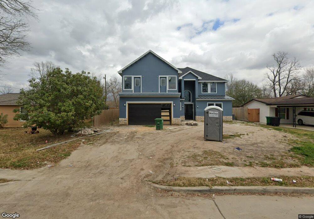
5215 Kelso St Houston, TX 77021
OST-South Union NeighborhoodEstimated Value: $484,000 - $699,000
4
Beds
5
Baths
4,298
Sq Ft
$130/Sq Ft
Est. Value
About This Home
This home is located at 5215 Kelso St, Houston, TX 77021 and is currently estimated at $558,333, approximately $129 per square foot. 5215 Kelso St is a home located in Harris County with nearby schools including Hartsfield Elementary Animal and Environmental Sciences Magnet, Cullen Middle School, and Yates High School.
Ownership History
Date
Name
Owned For
Owner Type
Purchase Details
Closed on
Aug 5, 2025
Sold by
Poston Patricia
Bought by
Mill City Mortgage Loan Trust and Wilmington Savings Fund Society Fsb
Current Estimated Value
Purchase Details
Closed on
Aug 17, 2020
Sold by
Curtis Willard F
Bought by
Bell Aryaspn S
Purchase Details
Closed on
May 26, 1995
Sold by
White Debra Diann and Fletcher Paula Michelle White
Bought by
Curtis Willard F
Create a Home Valuation Report for This Property
The Home Valuation Report is an in-depth analysis detailing your home's value as well as a comparison with similar homes in the area
Home Values in the Area
Average Home Value in this Area
Purchase History
| Date | Buyer | Sale Price | Title Company |
|---|---|---|---|
| Mill City Mortgage Loan Trust | $641,665 | None Listed On Document | |
| Bell Aryaspn S | -- | American Title Company | |
| Curtis Willard F | -- | Chicago Title |
Source: Public Records
Tax History Compared to Growth
Tax History
| Year | Tax Paid | Tax Assessment Tax Assessment Total Assessment is a certain percentage of the fair market value that is determined by local assessors to be the total taxable value of land and additions on the property. | Land | Improvement |
|---|---|---|---|---|
| 2025 | $14,286 | $564,106 | $83,442 | $480,664 |
| 2024 | $14,286 | $682,752 | $83,442 | $599,310 |
| 2023 | $14,286 | $713,873 | $83,442 | $630,431 |
| 2022 | $8,689 | $375,050 | $76,489 | $298,561 |
| 2021 | $1,297 | $55,628 | $55,628 | $0 |
| 2020 | $2,373 | $93,536 | $34,768 | $58,768 |
| 2019 | $2,201 | $83,205 | $29,552 | $53,653 |
| 2018 | $1,392 | $55,000 | $20,861 | $34,139 |
| 2017 | $1,454 | $55,000 | $20,861 | $34,139 |
| 2016 | $1,719 | $65,019 | $20,861 | $44,158 |
| 2015 | $1,289 | $65,019 | $20,861 | $44,158 |
| 2014 | $1,289 | $50,133 | $17,384 | $32,749 |
Source: Public Records
Map
Nearby Homes
- 5218 Kelso St
- 6527 Beekman Rd
- 5244 Enyart St
- 5210 Enyart St
- 5219 Cosby St
- 5251 Perry St
- 5259 Perry St
- 5224 Dewberry St
- 5107 Gren St
- 5111 Cosby St
- 5103 Yellowstone Blvd
- 5022 Balkin St
- 5251 Dewberry St
- 5601 Malmedy Rd
- 5322 Dewberry St
- 4611 Dewberry St
- 5023 Cosby St
- 5035 Andrea St
- 5014 Yellowstone Blvd
- 4927 Kelso St