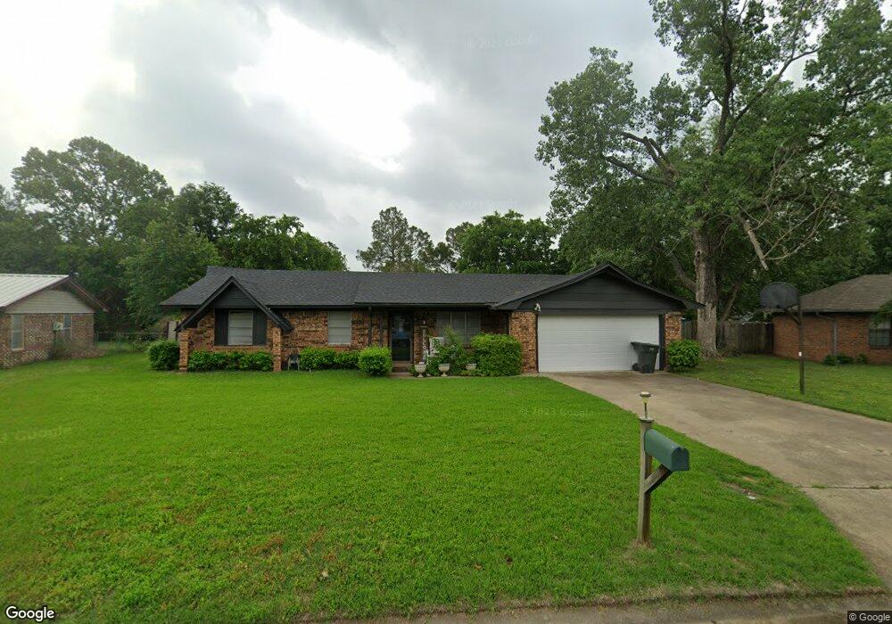
5216 Martin Cir Durant, OK 74701
Estimated Value: $157,000 - $217,000
3
Beds
2
Baths
1,560
Sq Ft
$128/Sq Ft
Est. Value
About This Home
This home is located at 5216 Martin Cir, Durant, OK 74701 and is currently estimated at $198,962, approximately $127 per square foot. 5216 Martin Cir is a home with nearby schools including Washington Irving Elementary School, Northwest Heights Elementary School, and Durant Intermediate Elementary School.
Ownership History
Date
Name
Owned For
Owner Type
Purchase Details
Closed on
Jan 25, 2024
Sold by
Cpr Properties Llc
Bought by
Eastwood Chris
Current Estimated Value
Purchase Details
Closed on
Jul 30, 2012
Sold by
Mowles Edward M
Bought by
Nankivil Regina
Home Financials for this Owner
Home Financials are based on the most recent Mortgage that was taken out on this home.
Original Mortgage
$60,000
Interest Rate
3.68%
Mortgage Type
New Conventional
Purchase Details
Closed on
Jan 21, 1994
Sold by
Nankivil Regina and Nankivil White S
Bought by
Mowles Edward M
Create a Home Valuation Report for This Property
The Home Valuation Report is an in-depth analysis detailing your home's value as well as a comparison with similar homes in the area
Home Values in the Area
Average Home Value in this Area
Purchase History
| Date | Buyer | Sale Price | Title Company |
|---|---|---|---|
| Eastwood Chris | -- | None Listed On Document | |
| Nankivil Regina | $75,000 | None Available | |
| Mowles Edward M | $36,100 | -- |
Source: Public Records
Mortgage History
| Date | Status | Borrower | Loan Amount |
|---|---|---|---|
| Previous Owner | Nankivil Regina | $60,000 |
Source: Public Records
Tax History Compared to Growth
Tax History
| Year | Tax Paid | Tax Assessment Tax Assessment Total Assessment is a certain percentage of the fair market value that is determined by local assessors to be the total taxable value of land and additions on the property. | Land | Improvement |
|---|---|---|---|---|
| 2024 | $1,047 | $10,751 | $1,481 | $9,270 |
| 2023 | $1,047 | $10,239 | $1,481 | $8,758 |
| 2022 | $961 | $10,239 | $1,481 | $8,758 |
| 2021 | $984 | $10,239 | $1,481 | $8,758 |
| 2020 | $983 | $10,239 | $1,481 | $8,758 |
| 2019 | $952 | $10,499 | $1,481 | $9,018 |
| 2018 | $904 | $10,057 | $1,481 | $8,576 |
| 2017 | $855 | $9,578 | $1,481 | $8,097 |
| 2016 | $884 | $9,821 | $1,430 | $8,391 |
| 2015 | $801 | $8,924 | $1,050 | $7,874 |
| 2014 | $800 | $8,924 | $1,050 | $7,874 |
Source: Public Records
Map
Nearby Homes
- 5428 Roadrunner Dr
- 5205 Pheasant Run
- 5456 Roadrunner Dr
- 5211 Roadrunner Dr
- 409 Roadrunner Dr
- 129 Highland Dr
- 101 Dunn St
- 19 Skylark Ln
- 5301 Stonebriar Cir
- 959 Knight Dr
- 5353 Stonebriar Cir
- 3075 Sawmill Rd
- 1425 Folsom Rd
- 5616 Stonecreek Dr
- 1602 Felice Ln
- 001 Knight Dr
- 0 Sand Trap Dr
- 18 Sandwedge
- 19 Blake Ln
- 20 Blake Ln
- 5214 Martin Cir
- 5427 Roadrunner Dr
- 5218 Martin Cir
- 5429 Roadrunner Dr
- 5425 Roadrunner Dr
- 5210 Martin Cir
- 5423 Roadrunner Dr
- 5489 Roadrunner Dr
- 5212 Martin Cir
- 0 Roadrunner Rd
- 5431 Roadrunner Dr
- 5421 Roadrunner Dr
- 5209 Pheasant Run
- 5301 Pheasant Run
- 5219 Martin Cir
- 5305 Pheasant Run
- 5426 Roadrunner Dr
- 5419 Roadrunner Dr
- 5422 Roadrunner Dr
- 5428 Roadrunner Dr