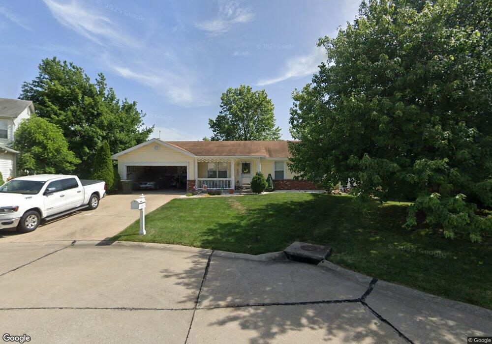
522 Atlas Ct Saint Peters, MO 63376
Estimated Value: $306,000 - $369,000
3
Beds
2
Baths
1,395
Sq Ft
$243/Sq Ft
Est. Value
About This Home
This home is located at 522 Atlas Ct, Saint Peters, MO 63376 and is currently estimated at $339,572, approximately $243 per square foot. 522 Atlas Ct is a home located in St. Charles County with nearby schools including Warren Elementary School, Saeger Middle School, and Francis Howell Central High School.
Ownership History
Date
Name
Owned For
Owner Type
Purchase Details
Closed on
Oct 31, 2002
Sold by
Walsh Elizabeth A
Bought by
Schulte Kevin D and Schulte Laura A
Current Estimated Value
Home Financials for this Owner
Home Financials are based on the most recent Mortgage that was taken out on this home.
Original Mortgage
$135,000
Outstanding Balance
$56,462
Interest Rate
6%
Estimated Equity
$283,110
Purchase Details
Closed on
Aug 15, 1997
Sold by
Nagel Timothy S and Nagel Pamela J
Bought by
Walsh Thomas E and Walsh Elizabeth A
Home Financials for this Owner
Home Financials are based on the most recent Mortgage that was taken out on this home.
Original Mortgage
$101,000
Interest Rate
7.46%
Create a Home Valuation Report for This Property
The Home Valuation Report is an in-depth analysis detailing your home's value as well as a comparison with similar homes in the area
Home Values in the Area
Average Home Value in this Area
Purchase History
| Date | Buyer | Sale Price | Title Company |
|---|---|---|---|
| Schulte Kevin D | $152,000 | -- | |
| Walsh Thomas E | -- | -- |
Source: Public Records
Mortgage History
| Date | Status | Borrower | Loan Amount |
|---|---|---|---|
| Open | Schulte Kevin D | $135,000 | |
| Previous Owner | Walsh Thomas E | $101,000 |
Source: Public Records
Tax History Compared to Growth
Tax History
| Year | Tax Paid | Tax Assessment Tax Assessment Total Assessment is a certain percentage of the fair market value that is determined by local assessors to be the total taxable value of land and additions on the property. | Land | Improvement |
|---|---|---|---|---|
| 2025 | $3,727 | $58,043 | -- | -- |
| 2023 | $3,723 | $53,345 | $0 | $0 |
| 2022 | $3,183 | $42,534 | $0 | $0 |
| 2021 | $3,177 | $42,534 | $0 | $0 |
| 2020 | $2,863 | $37,411 | $0 | $0 |
| 2019 | $2,854 | $37,411 | $0 | $0 |
| 2018 | $2,585 | $32,463 | $0 | $0 |
| 2017 | $2,573 | $32,463 | $0 | $0 |
| 2016 | $2,285 | $28,853 | $0 | $0 |
| 2015 | $2,281 | $28,853 | $0 | $0 |
| 2014 | $2,147 | $26,383 | $0 | $0 |
Source: Public Records
Map
Nearby Homes
- 1426 Venus Dr
- 309 Willott Square Dr
- 1012 Windstream Dr Unit 21
- 1 Marianne Dr
- 21 Kenworth Dr
- 213 Candice Way
- 116 Willott Square Dr
- 11 White Oak Dr
- 1 Oak Hill Ln
- Brookmont Plan at Ryehill Manor
- Parker Plan at Ryehill Manor
- Whitehall Plan at Ryehill Manor
- Lansford Plan at Ryehill Manor
- Stratton Plan at Ryehill Manor
- Winslow Plan at Ryehill Manor
- Carver Plan at Ryehill Manor
- Waverly Plan at Ryehill Manor
- 50 Oak Hill Ln
- 10 Eagles Glen Ct
- 525 Ryehill Dr