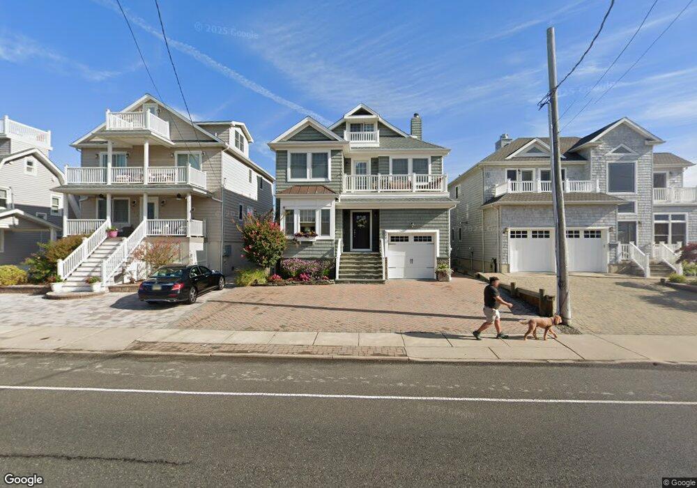
522 Brielle Rd Manasquan, NJ 08736
Estimated Value: $2,005,000 - $2,251,000
4
Beds
2
Baths
2,956
Sq Ft
$737/Sq Ft
Est. Value
About This Home
This home is located at 522 Brielle Rd, Manasquan, NJ 08736 and is currently estimated at $2,177,916, approximately $736 per square foot. 522 Brielle Rd is a home with nearby schools including Manasquan Elementary School and Manasquan High School.
Ownership History
Date
Name
Owned For
Owner Type
Purchase Details
Closed on
Mar 12, 1999
Sold by
Blore Marshall
Bought by
Irigaray Eduardo and Irigaray Maria
Current Estimated Value
Home Financials for this Owner
Home Financials are based on the most recent Mortgage that was taken out on this home.
Original Mortgage
$154,000
Outstanding Balance
$38,132
Interest Rate
7.02%
Estimated Equity
$2,139,784
Purchase Details
Closed on
Jan 31, 1995
Sold by
Konegan Kenneth
Bought by
Blore Marshall and Blore Janice
Home Financials for this Owner
Home Financials are based on the most recent Mortgage that was taken out on this home.
Original Mortgage
$114,000
Interest Rate
9.13%
Create a Home Valuation Report for This Property
The Home Valuation Report is an in-depth analysis detailing your home's value as well as a comparison with similar homes in the area
Home Values in the Area
Average Home Value in this Area
Purchase History
| Date | Buyer | Sale Price | Title Company |
|---|---|---|---|
| Irigaray Eduardo | $220,000 | -- | |
| Blore Marshall | $142,000 | -- |
Source: Public Records
Mortgage History
| Date | Status | Borrower | Loan Amount |
|---|---|---|---|
| Open | Irigaray Eduardo | $154,000 | |
| Previous Owner | Blore Marshall | $114,000 |
Source: Public Records
Tax History
| Year | Tax Paid | Tax Assessment Tax Assessment Total Assessment is a certain percentage of the fair market value that is determined by local assessors to be the total taxable value of land and additions on the property. | Land | Improvement |
|---|---|---|---|---|
| 2025 | $17,239 | $969,600 | $462,100 | $507,500 |
| 2024 | $16,590 | $969,600 | $462,100 | $507,500 |
Source: Public Records
Map
Nearby Homes
- 43 Pearce Ct
- 22 Crescent Dr
- 355 Cedar Ave
- 10 Waters Edge
- 329 Fisk Ave
- 23 Ocean Ave N
- 323-325 Fisk Ave
- 140 Ocean Ave
- 130 Union Ave
- 143 Boardwalk
- 202 Yale Ave
- 5 Water St
- 10 Brunswick Place
- 610 Agnes Ave
- 217 Neptune Place
- 219 Neptune Place
- 204 Curtis Ave
- 205 Stockton Blvd
- 11 Pearce Ave
- 806 Riverview Dr
Your Personal Tour Guide
Ask me questions while you tour the home.