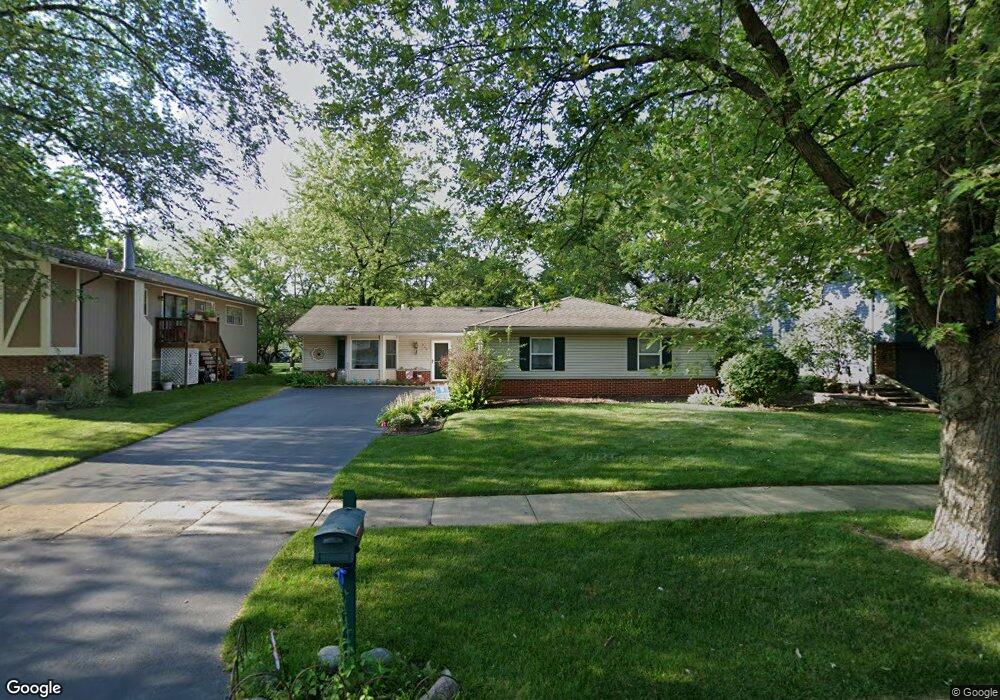
522 Castle Ct Bolingbrook, IL 60440
East Bolingbrook NeighborhoodEstimated Value: $299,338 - $366,000
3
Beds
2
Baths
1,493
Sq Ft
$226/Sq Ft
Est. Value
About This Home
This home is located at 522 Castle Ct, Bolingbrook, IL 60440 and is currently estimated at $336,835, approximately $225 per square foot. 522 Castle Ct is a home located in Will County with nearby schools including Jonas E Salk Elementary School, Hubert H Humphrey Middle School, and Bolingbrook High School.
Ownership History
Date
Name
Owned For
Owner Type
Purchase Details
Closed on
Jun 8, 2006
Sold by
Deb Satyajit and Deb Jennifer
Bought by
Savage Patricia A
Current Estimated Value
Home Financials for this Owner
Home Financials are based on the most recent Mortgage that was taken out on this home.
Original Mortgage
$187,000
Outstanding Balance
$110,861
Interest Rate
6.72%
Mortgage Type
Purchase Money Mortgage
Estimated Equity
$225,974
Purchase Details
Closed on
Jun 29, 2000
Sold by
Sherwood Brian L and Sherwood Angela J
Bought by
Deb Saryajit and Deb Jennifer
Purchase Details
Closed on
Jul 23, 1998
Sold by
Harmon Matthew M and Hill Harmon Celeste Marie
Bought by
Sherwood Brian L and Sherwood Angela J
Home Financials for this Owner
Home Financials are based on the most recent Mortgage that was taken out on this home.
Original Mortgage
$104,908
Interest Rate
6.99%
Mortgage Type
FHA
Purchase Details
Closed on
Jul 7, 1995
Sold by
Deguzman Roberto and Deguzman Myrna
Bought by
Hill Harmon Celeste Marie
Home Financials for this Owner
Home Financials are based on the most recent Mortgage that was taken out on this home.
Original Mortgage
$106,493
Interest Rate
7.79%
Mortgage Type
FHA
Create a Home Valuation Report for This Property
The Home Valuation Report is an in-depth analysis detailing your home's value as well as a comparison with similar homes in the area
Home Values in the Area
Average Home Value in this Area
Purchase History
| Date | Buyer | Sale Price | Title Company |
|---|---|---|---|
| Savage Patricia A | $237,000 | Multiple | |
| Deb Saryajit | $140,500 | -- | |
| Sherwood Brian L | $108,000 | -- | |
| Hill Harmon Celeste Marie | $108,000 | -- |
Source: Public Records
Mortgage History
| Date | Status | Borrower | Loan Amount |
|---|---|---|---|
| Open | Savage Patricia A | $187,000 | |
| Previous Owner | Sherwood Brian L | $104,908 | |
| Previous Owner | Hill Harmon Celeste Marie | $106,493 |
Source: Public Records
Tax History
| Year | Tax Paid | Tax Assessment Tax Assessment Total Assessment is a certain percentage of the fair market value that is determined by local assessors to be the total taxable value of land and additions on the property. | Land | Improvement |
|---|---|---|---|---|
| 2024 | $2,928 | $85,836 | $20,174 | $65,662 |
| 2023 | $2,928 | $77,232 | $18,152 | $59,080 |
| 2022 | $5,795 | $69,629 | $16,365 | $53,264 |
| 2021 | $3,695 | $65,105 | $15,302 | $49,803 |
| 2020 | $3,712 | $62,964 | $14,799 | $48,165 |
| 2019 | $3,787 | $59,965 | $14,094 | $45,871 |
| 2018 | $3,812 | $55,170 | $12,967 | $42,203 |
| 2017 | $3,847 | $59,248 | $12,291 | $46,957 |
| 2016 | $3,941 | $56,400 | $11,700 | $44,700 |
| 2015 | $3,952 | $52,500 | $10,900 | $41,600 |
| 2014 | $3,952 | $47,700 | $9,900 | $37,800 |
| 2013 | $3,952 | $47,700 | $9,900 | $37,800 |
Source: Public Records
Map
Nearby Homes
- 473 Rockhurst Rd
- 526 King Arthur Way
- 404 Galahad Rd
- 207 Seabury Rd
- 220 N Ashbury Ave
- 317 Homestead Dr
- 124 Seabury Rd
- 564 White Oak Rd
- 320 Homestead Dr
- 421 N Ashbury Ave
- 325 Rockhurst Rd
- 246 Homewood Dr
- 409 N Ashbury Ave
- 271 Stonegate Rd
- 505 Goodwin Dr
- 598 Miner Dr
- 354 Aaron Ln
- 547 Goodwin Dr
- 411 Assembly Dr
- 417 Monet Cir
Your Personal Tour Guide
Ask me questions while you tour the home.