Estimated Value: $791,000 - $945,000
4
Beds
2
Baths
1,948
Sq Ft
$432/Sq Ft
Est. Value
About This Home
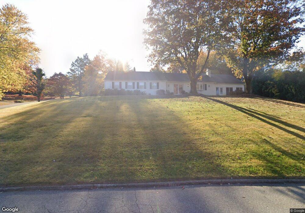
This home is located at 522 Colonel Dewees Rd, Wayne, PA 19087 and is currently estimated at $841,343, approximately $431 per square foot. 522 Colonel Dewees Rd is a home located in Chester County with nearby schools including Valley Forge Elementary School, Valley Forge Middle School, and Conestoga Senior High School.
Ownership History
Date
Name
Owned For
Owner Type
Purchase Details
Closed on
Jun 6, 2025
Sold by
Sirull Arnold B and Sirull Diane Roggen
Bought by
Sirull Diane Roggen
Current Estimated Value
Purchase Details
Closed on
May 13, 1994
Sold by
Schwengber Janet
Bought by
Clare Robert A and Clare Lorraine S
Home Financials for this Owner
Home Financials are based on the most recent Mortgage that was taken out on this home.
Original Mortgage
$200,000
Interest Rate
8.5%
Create a Home Valuation Report for This Property
The Home Valuation Report is an in-depth analysis detailing your home's value as well as a comparison with similar homes in the area
Home Values in the Area
Average Home Value in this Area
Purchase History
| Date | Buyer | Sale Price | Title Company |
|---|---|---|---|
| Sirull Diane Roggen | -- | None Listed On Document | |
| Clare Robert A | $25,000 | -- |
Source: Public Records
Mortgage History
| Date | Status | Borrower | Loan Amount |
|---|---|---|---|
| Previous Owner | Clare Robert A | $200,000 |
Source: Public Records
Tax History
| Year | Tax Paid | Tax Assessment Tax Assessment Total Assessment is a certain percentage of the fair market value that is determined by local assessors to be the total taxable value of land and additions on the property. | Land | Improvement |
|---|---|---|---|---|
| 2025 | $8,461 | $240,220 | $77,100 | $163,120 |
| 2024 | $8,461 | $240,220 | $77,100 | $163,120 |
| 2023 | $7,948 | $240,220 | $77,100 | $163,120 |
| 2022 | $7,743 | $240,220 | $77,100 | $163,120 |
| 2021 | $7,596 | $240,220 | $77,100 | $163,120 |
| 2020 | $7,386 | $240,220 | $77,100 | $163,120 |
| 2019 | $7,153 | $240,220 | $77,100 | $163,120 |
| 2018 | $7,011 | $240,220 | $77,100 | $163,120 |
| 2017 | $6,844 | $240,220 | $77,100 | $163,120 |
| 2016 | -- | $240,220 | $77,100 | $163,120 |
| 2015 | -- | $240,220 | $77,100 | $163,120 |
| 2014 | -- | $240,220 | $77,100 | $163,120 |
Source: Public Records
Map
Nearby Homes
- 1450 Thomas Rd
- 419 Drummers Ln Unit 419
- 190 Drummers Ln
- 356 Drummers Ln Unit 356
- 262 Drummers Ln Unit 262
- 275 Drummers Ln Unit 275
- 421 Drummers Ln Unit 421
- 290 Drummers Ln Unit 290
- 137 Drummers Ln
- 71 Drummers Ln Unit 71
- 124 Drummers Ln
- 714 Gulph Rd
- 767 Gulph Rd
- 1211 Reed Aly
- 908 Laurens Aly
- 575 S Goddard Blvd Unit 215
- 575 S Goddard Blvd Unit 505
- 575 S Goddard Blvd Unit 502
- 575 S Goddard Blvd Unit 303
- 575 S Goddard Blvd Unit 405
- 528 General Scott Rd
- 1391 Thomas Rd
- 1375 Thomas Rd
- 540 Colonel Dewees Rd
- 517 Colonel Dewees Rd
- 540 General Scott Rd
- 521 General Scott Rd
- 529 Colonel Dewees Rd
- 1359 Thomas Rd
- 505 Colonel Dewees Rd
- 531 General Scott Rd
- 541 Colonel Dewees Rd
- 550 General Scott Rd
- 1343 Thomas Rd
- 608 Baron Dekalb Rd
- 555 Colonel Dewees Rd
- 620 Baron Dekalb Rd
- 551 General Scott Rd
- 1427 Thomas Rd
- 1406 Thomas Rd
Your Personal Tour Guide
Ask me questions while you tour the home.