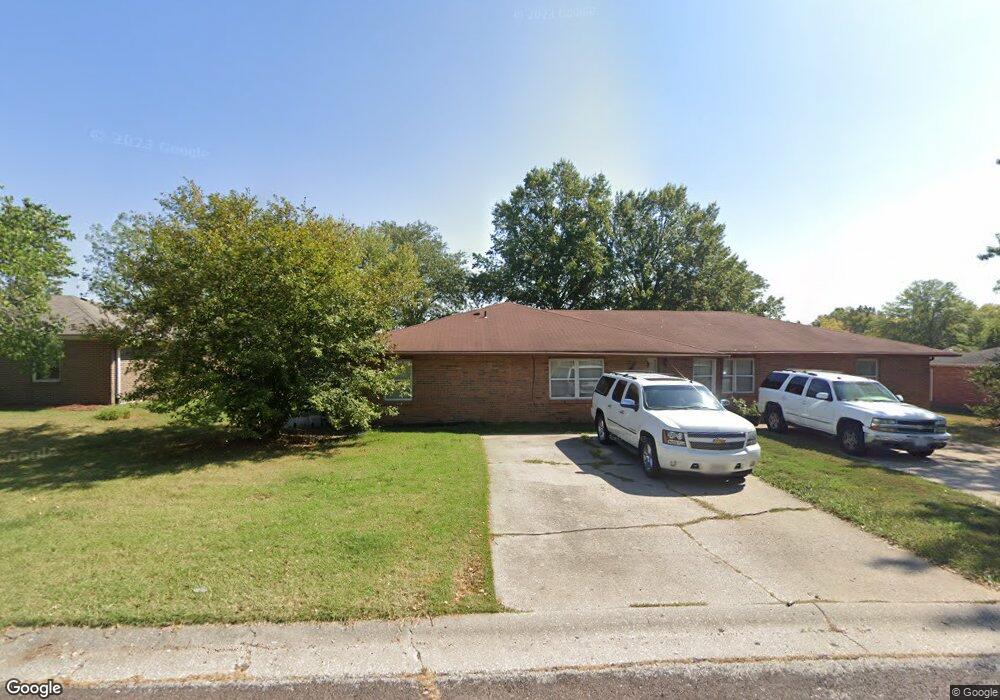
522 Pear Tree Cir Unit 524 Columbia, MO 65203
Cedar Lake NeighborhoodEstimated Value: $276,000 - $301,322
6
Beds
4
Baths
2,470
Sq Ft
$118/Sq Ft
Est. Value
About This Home
This home is located at 522 Pear Tree Cir Unit 524, Columbia, MO 65203 and is currently estimated at $291,441, approximately $117 per square foot. 522 Pear Tree Cir Unit 524 is a home located in Boone County with nearby schools including Mill Creek Elementary School, Ann Hawkins Gentry Middle School, and Rock Bridge High School.
Ownership History
Date
Name
Owned For
Owner Type
Purchase Details
Closed on
Dec 30, 2015
Sold by
Singsen Bernhard H and Coastal Valleys Charitable Rem
Bought by
Maddox And Robinson Investments Llc
Current Estimated Value
Home Financials for this Owner
Home Financials are based on the most recent Mortgage that was taken out on this home.
Original Mortgage
$116,937
Outstanding Balance
$93,063
Interest Rate
3.98%
Mortgage Type
Commercial
Estimated Equity
$198,378
Purchase Details
Closed on
Dec 5, 2015
Sold by
Singsen Bernhard H
Bought by
Coastal Valleys Charitable Remainder Uni
Home Financials for this Owner
Home Financials are based on the most recent Mortgage that was taken out on this home.
Original Mortgage
$116,937
Outstanding Balance
$93,063
Interest Rate
3.98%
Mortgage Type
Commercial
Estimated Equity
$198,378
Create a Home Valuation Report for This Property
The Home Valuation Report is an in-depth analysis detailing your home's value as well as a comparison with similar homes in the area
Home Values in the Area
Average Home Value in this Area
Purchase History
| Date | Buyer | Sale Price | Title Company |
|---|---|---|---|
| Maddox And Robinson Investments Llc | -- | None Available | |
| Coastal Valleys Charitable Remainder Uni | -- | None Available |
Source: Public Records
Mortgage History
| Date | Status | Borrower | Loan Amount |
|---|---|---|---|
| Open | Maddox And Robinson Investments Llc | $116,937 |
Source: Public Records
Tax History
| Year | Tax Paid | Tax Assessment Tax Assessment Total Assessment is a certain percentage of the fair market value that is determined by local assessors to be the total taxable value of land and additions on the property. | Land | Improvement |
|---|---|---|---|---|
| 2025 | $1,632 | $24,928 | $4,237 | $20,691 |
| 2024 | $1,529 | $22,667 | $4,237 | $18,430 |
| 2023 | $1,517 | $22,667 | $4,237 | $18,430 |
| 2022 | $1,457 | $21,793 | $4,237 | $17,556 |
| 2021 | $1,459 | $21,793 | $4,237 | $17,556 |
| 2020 | $1,437 | $20,170 | $4,237 | $15,933 |
| 2019 | $1,437 | $20,170 | $4,237 | $15,933 |
| 2018 | $1,340 | $0 | $0 | $0 |
| 2017 | $1,324 | $18,677 | $4,237 | $14,440 |
| 2016 | $1,322 | $18,677 | $4,237 | $14,440 |
| 2015 | $1,214 | $18,677 | $4,237 | $14,440 |
| 2014 | $1,218 | $18,677 | $4,237 | $14,440 |
Source: Public Records
Map
Nearby Homes
- 701 N Cedar Lake Dr W
- 902 Shakertown Way
- LOT 136 Clear Creek Estates
- LOT 129 Clear Creek Estates
- LOT 101 Clear Creek Estates
- LOT 128 Clear Creek Estates
- 500 Sudbury Dr
- 5109 Rosewood Ct
- 18 N Cedar Lake Dr W
- 504 Dustin Dr
- 1201 Sutton Dr
- 1208 Tartan Place
- 3 ACRES W Bethel Dr
- 4403 Glen Eagle Dr
- 1317 Troon Dr
- 3809 Wakefield Dr
- 3808 Barrington Dr
- 4301 Glen Eagle Dr
- 4304 Royal Aberdeen St
- 809 Rutland Dr
- 512 Pear Tree Cir Unit 514
- 532 Pear Tree Cir Unit 534
- 4657 Apple Tree Ln Unit 4659
- 523-525 Pear Tree Cir
- 523 Pear Tree Cir Unit 525
- 4705 Apple Tree Ln Unit 4707
- 515 Pear Tree Cir
- 513 Pear Tree Cir Unit 515
- 545 Pear Tree Cir
- 532 Southampton Dr Unit 534
- 534 W Southampton Dr
- 543 Pear Tree Cir Unit 545
- 4631 Apple Tree Ln Unit 4633
- 532 W Southampton Dr
- 4605 Apple Tree Ln
- 542 Pear Tree Cir Unit 544
- 4731 Apple Tree Ln Unit 4733
- 558-560 W Southampton Dr
- 4733 Apple Tree Ln
- 506 Southampton Dr
Your Personal Tour Guide
Ask me questions while you tour the home.