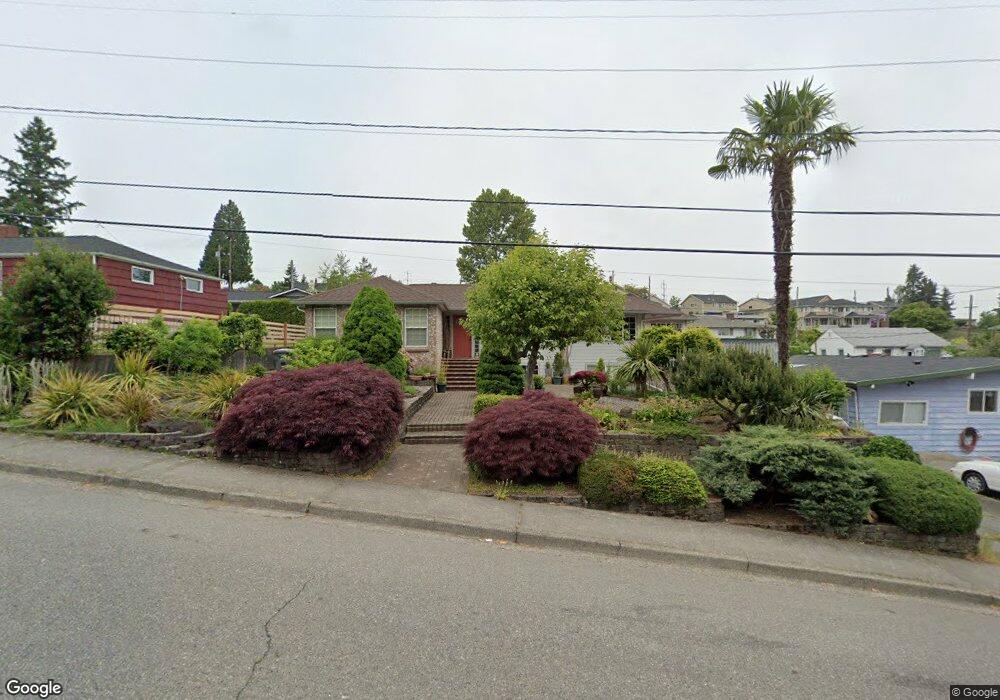
522 SW Langston Rd Renton, WA 98057
West Hill NeighborhoodEstimated Value: $743,180 - $824,000
3
Beds
3
Baths
2,190
Sq Ft
$359/Sq Ft
Est. Value
About This Home
This home is located at 522 SW Langston Rd, Renton, WA 98057 and is currently estimated at $787,295, approximately $359 per square foot. 522 SW Langston Rd is a home located in King County with nearby schools including Bryn Mawr Elementary School, Dimmitt Middle School, and Renton Senior High School.
Ownership History
Date
Name
Owned For
Owner Type
Purchase Details
Closed on
Jun 14, 2002
Sold by
Lorraine Bea
Bought by
Bennett Frank P and Bennett Luz A
Current Estimated Value
Purchase Details
Closed on
Dec 26, 1991
Sold by
Bennett Frank P
Bought by
Bennett Frank P and Bennett Lau A
Purchase Details
Closed on
Jan 9, 1979
Sold by
Orlyck Theodore J and Orlyck Carole
Bought by
Bennett Frank and Bennett Luzviminda A
Create a Home Valuation Report for This Property
The Home Valuation Report is an in-depth analysis detailing your home's value as well as a comparison with similar homes in the area
Home Values in the Area
Average Home Value in this Area
Purchase History
| Date | Buyer | Sale Price | Title Company |
|---|---|---|---|
| Bennett Frank P | -- | Old Republic T | |
| Bennett Frank P | -- | -- | |
| Bennett Frank | -- | Transamerica Title Ins Svcs |
Source: Public Records
Tax History Compared to Growth
Tax History
| Year | Tax Paid | Tax Assessment Tax Assessment Total Assessment is a certain percentage of the fair market value that is determined by local assessors to be the total taxable value of land and additions on the property. | Land | Improvement |
|---|---|---|---|---|
| 2024 | $584 | $785,000 | $327,000 | $458,000 |
| 2023 | $608 | $659,000 | $189,000 | $470,000 |
| 2022 | $701 | $711,000 | $199,000 | $512,000 |
| 2021 | $741 | $584,000 | $164,000 | $420,000 |
| 2020 | $743 | $244,000 | $69,000 | $175,000 |
| 2018 | $777 | $244,000 | $69,000 | $175,000 |
| 2017 | $882 | $443,000 | $105,000 | $338,000 |
| 2016 | $776 | $381,000 | $90,000 | $291,000 |
| 2015 | $794 | $349,000 | $83,000 | $266,000 |
| 2014 | -- | $315,000 | $74,000 | $241,000 |
| 2013 | -- | $235,000 | $68,000 | $167,000 |
Source: Public Records
Map
Nearby Homes
- 409 SW Langston Rd
- 811 SW Langston Rd
- 0 Lind Ave NW Unit NWM2332119
- 8225 S 132nd St
- 13076 Renton Ave S
- 611 SW 5th Ct Unit A401
- 13146 83rd Ln S
- 833 SW Sunset Blvd Unit I42
- 271 Hardie Ave NW
- 7879 S 132nd St
- 7853 S 132nd St
- 7652 S 135th St
- 7662 S 134th St
- 12828 78th Ave S
- 601 Shattuck Ave S
- 7804 S 128th St
- 225 Logan Ave S Unit 108
- 82 5X S 132nd St
- 7560 S 130th Place
- 13031 75th Place S
- 518 SW Langston Rd
- 602 SW Langston Rd
- 516 SW Langston Place
- 514 SW Langston Place
- 510 SW Langston Rd
- 522 SW Langston Place
- 512 SW Langston Place
- 525 SW Langston Rd
- 521 SW Langston Rd
- 600 SW Langston Place
- 504 SW Langston Place
- 517 SW Langston Rd
- 502 SW Langston Rd
- 608 SW Langston Place
- 511 SW Langston Rd
- 424 SW Langston Place
- 252 Earlington Ave SW
- 256 Earlington Ave SW
- 420 SW Langston Rd
- 609 SW Langston Rd