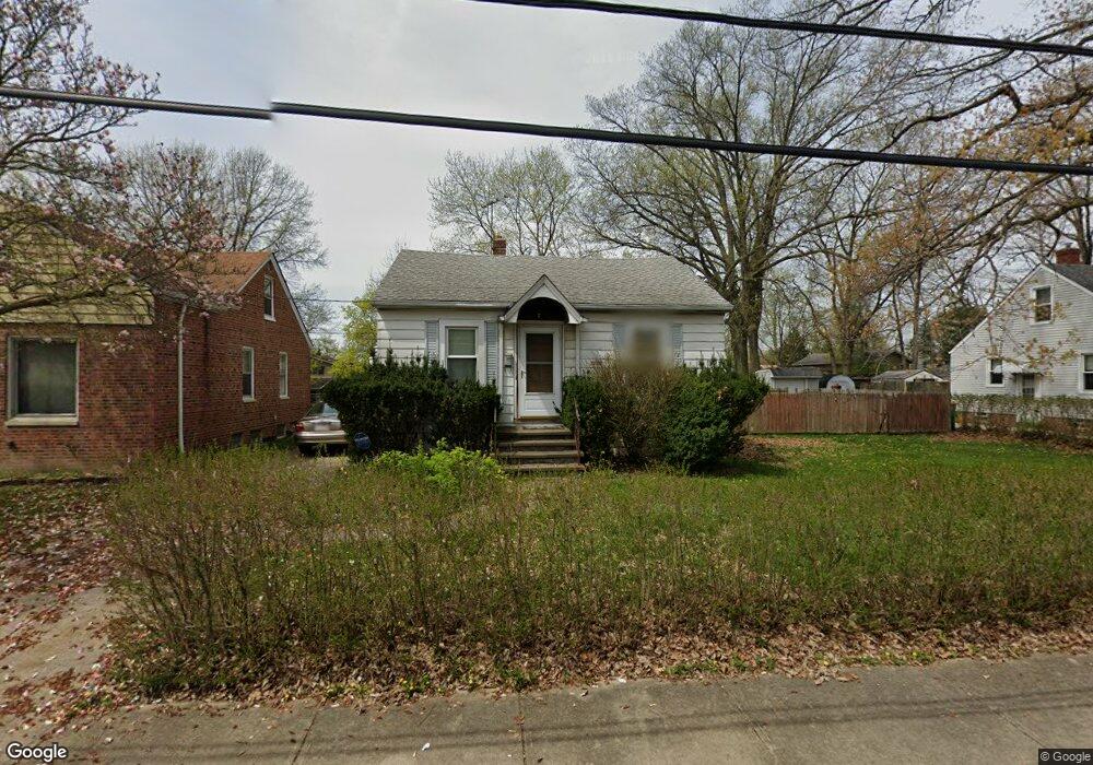
5226 Milo Ave Maple Heights, OH 44137
Estimated Value: $91,000 - $121,243
2
Beds
1
Bath
772
Sq Ft
$144/Sq Ft
Est. Value
About This Home
This home is located at 5226 Milo Ave, Maple Heights, OH 44137 and is currently estimated at $110,811, approximately $143 per square foot. 5226 Milo Ave is a home located in Cuyahoga County with nearby schools including Abraham Lincoln Elementary School, Rockside/ J.F. Kennedy School, and Barack Obama School.
Ownership History
Date
Name
Owned For
Owner Type
Purchase Details
Closed on
Sep 15, 1992
Sold by
Triptow Kurt P
Bought by
Osretkar Tonja
Current Estimated Value
Purchase Details
Closed on
Aug 4, 1989
Sold by
Block Kenneth E
Bought by
Triptow Kurt P
Purchase Details
Closed on
Apr 3, 1985
Sold by
Block Kenneth E
Bought by
Block Kenneth E
Purchase Details
Closed on
Mar 7, 1985
Sold by
Karwan Andrew S
Bought by
Block Kenneth E
Purchase Details
Closed on
Feb 15, 1985
Sold by
Karwan Andrew S
Bought by
Karwan Andrew S
Purchase Details
Closed on
Aug 10, 1976
Sold by
Karwan Andrew S and Karwan Esther L
Bought by
Karwan Andrew S
Purchase Details
Closed on
Jan 1, 1975
Bought by
Karwan Andrew S and Karwan Esther L
Create a Home Valuation Report for This Property
The Home Valuation Report is an in-depth analysis detailing your home's value as well as a comparison with similar homes in the area
Home Values in the Area
Average Home Value in this Area
Purchase History
| Date | Buyer | Sale Price | Title Company |
|---|---|---|---|
| Osretkar Tonja | $58,000 | -- | |
| Triptow Kurt P | $52,500 | -- | |
| Block Kenneth E | -- | -- | |
| Block Kenneth E | $44,900 | -- | |
| Karwan Andrew S | -- | -- | |
| Karwan Andrew S | -- | -- | |
| Karwan Andrew S | -- | -- |
Source: Public Records
Tax History Compared to Growth
Tax History
| Year | Tax Paid | Tax Assessment Tax Assessment Total Assessment is a certain percentage of the fair market value that is determined by local assessors to be the total taxable value of land and additions on the property. | Land | Improvement |
|---|---|---|---|---|
| 2024 | $3,514 | $39,410 | $7,140 | $32,270 |
| 2023 | $2,715 | $26,010 | $3,780 | $22,230 |
| 2022 | $2,705 | $26,010 | $3,780 | $22,230 |
| 2021 | $2,887 | $26,010 | $3,780 | $22,230 |
| 2020 | $2,458 | $19,710 | $2,870 | $16,840 |
| 2019 | $2,447 | $56,300 | $8,200 | $48,100 |
| 2018 | $2,434 | $19,710 | $2,870 | $16,840 |
| 2017 | $2,603 | $20,830 | $3,640 | $17,190 |
| 2016 | $2,519 | $20,830 | $3,640 | $17,190 |
| 2015 | $2,396 | $20,830 | $3,640 | $17,190 |
| 2014 | $2,396 | $21,460 | $3,750 | $17,710 |
Source: Public Records
Map
Nearby Homes
- 5312 E 141st St
- 13601 Granger Rd
- 13417 Granger Rd
- 5310 Kohout St
- 5362 Roland Dr
- 14567 Pease Rd
- 5107 E 131st St
- 13005 Oak St
- 12908 Oak St
- 5100 Greenhurst Dr
- 15095 Granger Rd
- 5372 E 131st St
- 5392 E 131st St
- 12816 Mccracken Rd
- 5499 E 141st St
- 12830 Park Knoll Dr
- 5351 E 124th St
- 14405 Corridon Ave
- 13009 Oak Park Blvd
- 13300 Shady Oak Blvd