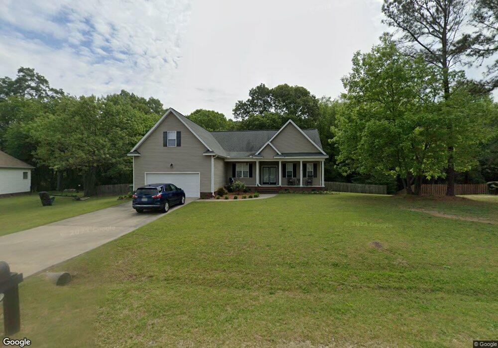
523 Johnson Branch Rd Goldsboro, NC 27534
Estimated Value: $287,000 - $306,000
3
Beds
2
Baths
1,924
Sq Ft
$154/Sq Ft
Est. Value
About This Home
This home is located at 523 Johnson Branch Rd, Goldsboro, NC 27534 and is currently estimated at $296,229, approximately $153 per square foot. 523 Johnson Branch Rd is a home located in Wayne County with nearby schools including Northeast Elementary School, Norwayne Middle School, and Charles B. Aycock High School.
Ownership History
Date
Name
Owned For
Owner Type
Purchase Details
Closed on
Mar 18, 2005
Sold by
Harris Construction Development Llc
Bought by
Bonnar Linda E and Bonnar Hugh S
Current Estimated Value
Home Financials for this Owner
Home Financials are based on the most recent Mortgage that was taken out on this home.
Original Mortgage
$148,000
Interest Rate
5.54%
Mortgage Type
New Conventional
Purchase Details
Closed on
Nov 1, 2004
Create a Home Valuation Report for This Property
The Home Valuation Report is an in-depth analysis detailing your home's value as well as a comparison with similar homes in the area
Home Values in the Area
Average Home Value in this Area
Purchase History
| Date | Buyer | Sale Price | Title Company |
|---|---|---|---|
| Bonnar Linda E | $185,000 | None Available | |
| -- | $96,000 | -- |
Source: Public Records
Mortgage History
| Date | Status | Borrower | Loan Amount |
|---|---|---|---|
| Previous Owner | Bonnar Linda E | $148,000 | |
| Previous Owner | Bonnar Linda E | $18,500 |
Source: Public Records
Tax History Compared to Growth
Tax History
| Year | Tax Paid | Tax Assessment Tax Assessment Total Assessment is a certain percentage of the fair market value that is determined by local assessors to be the total taxable value of land and additions on the property. | Land | Improvement |
|---|---|---|---|---|
| 2025 | $2,071 | $290,480 | $38,500 | $251,980 |
| 2024 | $1,626 | $187,620 | $26,400 | $161,220 |
| 2023 | $1,579 | $187,620 | $26,400 | $161,220 |
| 2022 | $1,579 | $187,620 | $26,400 | $161,220 |
| 2021 | $1,513 | $187,620 | $26,400 | $161,220 |
| 2020 | $1,431 | $187,620 | $26,400 | $161,220 |
| 2018 | $1,616 | $212,790 | $26,400 | $186,390 |
| 2017 | $1,585 | $212,790 | $26,400 | $186,390 |
| 2016 | $1,585 | $212,790 | $26,400 | $186,390 |
| 2015 | $1,577 | $212,790 | $26,400 | $186,390 |
| 2014 | $1,580 | $212,790 | $26,400 | $186,390 |
Source: Public Records
Map
Nearby Homes
- 108 Castaway Ct
- 510 Planters Ridge Dr
- 201 Heron Dr
- 125 Heron Dr
- 00 Hill Loop Rd
- 110 Summerdale Dr
- 104 E Sillinger Dr
- 103 W Sillinger Dr
- 102 Wilderness Dr
- 5824 Wayne Memorial Dr NE
- 109 Wilderness Dr
- 0 Hill Loop Unit 100527984
- 128 W Hill St
- 101 Lucky Ln
- 100 Lucky Ln
- 103 Lucky Ln
- 102 Lucky Ln
- 105 Lucky Ln
- 107 Lucky Ln
- 109 Lucky Ln
- 525 Johnson Branch Rd
- 521 Johnson Branch Rd
- 521 Johnson
- 527 Johnson Branch Rd
- 519 Johnson Branch Rd
- 520 Johnson Branch Rd
- 522 Johnson Branch Rd
- 524 Johnson Branch Rd
- 518 Johnson Branch Rd
- 529 Johnson Branch Rd
- 517 Johnson Branch Rd
- 526 Johnson Branch Rd
- 106 Remount Rd
- 516 Johnson Branch Rd
- 108 Remount Rd
- 203 Clayside Dr
- 110 Remount Rd
- 515 Johnson Branch Rd
- 514 Johnson Branch Rd
- 112 Remount Rd