Estimated Value: $167,000 - $238,832
3
Beds
2
Baths
1,036
Sq Ft
$185/Sq Ft
Est. Value
About This Home
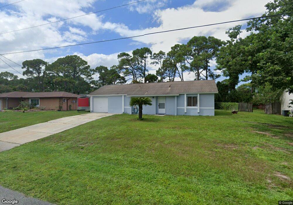
This home is located at 5230 Fruitport St, Cocoa, FL 32927 and is currently estimated at $191,708, approximately $185 per square foot. 5230 Fruitport St is a home located in Brevard County with nearby schools including Challenger 7 Elementary School, Space Coast Junior/Senior High School, and Sculptor Charter School.
Ownership History
Date
Name
Owned For
Owner Type
Purchase Details
Closed on
Apr 24, 2025
Sold by
Darryl Bradley White Trust and Cullen Jay J
Bought by
Doherty Gary
Current Estimated Value
Home Financials for this Owner
Home Financials are based on the most recent Mortgage that was taken out on this home.
Original Mortgage
$137,700
Outstanding Balance
$137,089
Interest Rate
6.65%
Mortgage Type
VA
Estimated Equity
$54,619
Purchase Details
Closed on
Jan 27, 2012
Sold by
White Darry B
Bought by
White Darryl Bradley and Darryl Bradley White Trust
Create a Home Valuation Report for This Property
The Home Valuation Report is an in-depth analysis detailing your home's value as well as a comparison with similar homes in the area
Home Values in the Area
Average Home Value in this Area
Purchase History
| Date | Buyer | Sale Price | Title Company |
|---|---|---|---|
| Doherty Gary | $170,000 | None Listed On Document | |
| Doherty Gary | $170,000 | None Listed On Document | |
| White Darryl Bradley | -- | Attorney |
Source: Public Records
Mortgage History
| Date | Status | Borrower | Loan Amount |
|---|---|---|---|
| Open | Doherty Gary | $137,700 | |
| Closed | Doherty Gary | $137,700 |
Source: Public Records
Tax History Compared to Growth
Tax History
| Year | Tax Paid | Tax Assessment Tax Assessment Total Assessment is a certain percentage of the fair market value that is determined by local assessors to be the total taxable value of land and additions on the property. | Land | Improvement |
|---|---|---|---|---|
| 2025 | $2,700 | $194,740 | -- | -- |
| 2024 | $2,642 | $198,350 | -- | -- |
| 2023 | $2,642 | $197,380 | $0 | $0 |
| 2022 | $2,380 | $187,420 | $0 | $0 |
| 2021 | $2,145 | $140,350 | $42,000 | $98,350 |
| 2020 | $1,982 | $125,700 | $40,000 | $85,700 |
| 2019 | $1,869 | $120,640 | $35,000 | $85,640 |
| 2018 | $1,769 | $109,360 | $27,000 | $82,360 |
| 2017 | $1,677 | $97,180 | $24,000 | $73,180 |
| 2016 | $1,566 | $82,440 | $18,000 | $64,440 |
| 2015 | $1,487 | $64,250 | $15,000 | $49,250 |
| 2014 | $1,357 | $58,410 | $11,000 | $47,410 |
Source: Public Records
Map
Nearby Homes
- 00 Unknown
- 6375 Cable Ave
- 0000 Grissom Pkwy
- 6760 Cairo Rd
- 6620 Grissom Pkwy
- 6615 Dock Ave
- 5220 Holden Rd
- 5215 Holden Rd
- 5275 Holden Rd
- 6775 Buxton Ave
- 6735 Grissom Pkwy
- 5049 Jamaica Rd
- 4975 Fay Blvd
- 6581 Bancroft Ave
- 5265 Fay Blvd
- 6390 Depot Ave
- 6175 Grissom Pkwy
- 5575 Curtis Blvd
- 6094 Cardiff Ave
- 4790 Greenhill St
- 362 Akron St S
- 2401 N Highway 1 Hwy NW Unit 204
- 7240 N Highway 1 W Unit 103
- 5240 Fruitport St
- 5220 Fruitport St
- 00000 Vacant Lot South of Grissom Pkwy
- 7030 Hwy Us1 Unit 102
- 7460 & 746 Ester Rd
- 5430 Unknown Ave
- 5250 Fruitport St
- 5210 Fruitport St
- 6470 Abisco Rd
- 6850 N Hwy 1 Unit 5308
- 5167 Arlington Rd
- 5173 Arlington Rd
- 6473 Dane Ave
- 2312487 Unknown
- 5155 Arlington Rd
- 6475 Abisco Rd
- 5260 Fruitport St