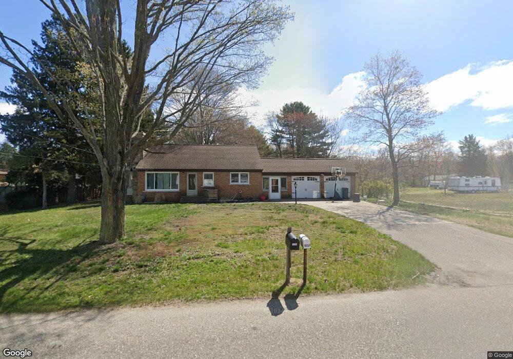
5232 Davis Rd Norton Shores, MI 49441
Estimated Value: $251,000 - $289,000
3
Beds
1
Bath
1,080
Sq Ft
$247/Sq Ft
Est. Value
About This Home
This home is located at 5232 Davis Rd, Norton Shores, MI 49441 and is currently estimated at $266,582, approximately $246 per square foot. 5232 Davis Rd is a home located in Muskegon County with nearby schools including Mona Shores High School, Michigan Dunes Montessori School, and West Shore Lutheran School.
Ownership History
Date
Name
Owned For
Owner Type
Purchase Details
Closed on
May 14, 2015
Sold by
Johnson Brian S and Johnson Brooke A
Bought by
Twenty One 25 Properties Llc
Current Estimated Value
Purchase Details
Closed on
Mar 26, 2010
Sold by
Johnson Brooke A and Fialek Brooke A
Bought by
Johnson Brooke A and Johnson Brian S
Purchase Details
Closed on
May 9, 2003
Sold by
Boven Donald N and Boven Barbara J
Bought by
Fialek Brooke A
Home Financials for this Owner
Home Financials are based on the most recent Mortgage that was taken out on this home.
Original Mortgage
$117,075
Interest Rate
5.87%
Mortgage Type
FHA
Create a Home Valuation Report for This Property
The Home Valuation Report is an in-depth analysis detailing your home's value as well as a comparison with similar homes in the area
Home Values in the Area
Average Home Value in this Area
Purchase History
| Date | Buyer | Sale Price | Title Company |
|---|---|---|---|
| Twenty One 25 Properties Llc | -- | None Available | |
| Johnson Brooke A | -- | None Available | |
| Fialek Brooke A | -- | -- |
Source: Public Records
Mortgage History
| Date | Status | Borrower | Loan Amount |
|---|---|---|---|
| Previous Owner | Fialek Brooke A | $117,075 |
Source: Public Records
Tax History Compared to Growth
Tax History
| Year | Tax Paid | Tax Assessment Tax Assessment Total Assessment is a certain percentage of the fair market value that is determined by local assessors to be the total taxable value of land and additions on the property. | Land | Improvement |
|---|---|---|---|---|
| 2025 | $3,705 | $110,000 | $0 | $0 |
| 2024 | $2,575 | $103,100 | $0 | $0 |
| 2023 | $2,458 | $86,600 | $0 | $0 |
| 2022 | $3,375 | $75,900 | $0 | $0 |
| 2021 | $3,276 | $71,100 | $0 | $0 |
| 2020 | $3,236 | $66,200 | $0 | $0 |
| 2019 | $3,177 | $61,500 | $0 | $0 |
| 2018 | $3,102 | $62,100 | $0 | $0 |
| 2017 | $3,033 | $59,900 | $0 | $0 |
| 2016 | $2,085 | $56,200 | $0 | $0 |
| 2015 | -- | $54,200 | $0 | $0 |
| 2014 | -- | $52,700 | $0 | $0 |
| 2013 | -- | $50,200 | $0 | $0 |
Source: Public Records
Map
Nearby Homes
- 5153 Shady Creek Dr
- 5085 Gay St
- 5128 Henry St
- 5075 Wickham Dr
- 608 Porter Rd
- 1103 W Mount Garfield Rd
- 1087 W Mount Garfield Rd
- 4666 Heinicke St
- 4655 Henry St
- 1769 Bayview Dr
- 1887 Hendrick Rd
- 1558 Brookwood Dr
- 516 Hendrick Rd
- 5043 Maranatha Dr
- 5959 Lake Harbor Rd
- 6023 Henry St
- 263 Churchill Dr
- 4235 Braeburn Ct
- 4230 Braeburn Ct
- 4676 Earl St